How to Use
Step 1: Define the project objective
Defining the specific project objectives related to building (is)lands. Is the objective nature development, land reclamation, improving water quality or getting rid of excessive sediments? Everything else follows from the project objectives (e.g. which processes are important, how to setup the project).
Subsequently, the next step depends on the specific case in which you apply the concept. Roughly, there are two possible cases: (1) you have a location with an excess of sediment and want to use the sediment in a beneficial way (most of the cases), or (2) you want to build land or islands, but still need to locate a source of sediment.
Step 2: What is the sediment source, where can it be found and how much is available?
In the first instance, you already have a sediment source. In that case, find out whether the sediment can be obtained (e.g. dredged) and what the origin of this sediment source is. In the second case, you need to look for a source of sediment. Lakes and ports are often sheltered areas where sediment settles, but there are also Building with Nature strategies that focus on sedimentation of fine sediments in turbid waters. In this case, it will take some time before you can obtain the required sediment. Note that (transport) distance is often a key determination for the economic feasibility. Therefore, the source should be near the application location (how near depends on the project goals, (dredging) technique and transport used).
The origin of the sediment sets the properties of the fine material to be used. Special attention should be given to the potential presence of contaminants in the sediment source. Because of the large surface area and chemical properties of clay particles, contaminants are often adsorbed to clay particles and may be transported. Therefore, pollutants are generally found in cohesive fine sediment deposits. For example, recently it was found that dredged fines in the port of Harlingen (the Netherlands) satisfies the required quality for the most part (see documentation Mudmotor Koehoal). In the mouth of the port, the quality was generally good, while in the corners of the port, furthest away from the mouth, contaminated sediments were found that could not be used for application or disposal.
Once the source of sediment is known, it should be determined how much sediment is available. This sets the dimensions for the islands that you can create. A consideration is to implement a phased building of islands, so that enough material is or becomes available over time.
Step 3: Understanding the local hydrodynamic conditions
Key to this approach is a good understanding of the system, before planning any measures. This is an integral part of the Building with Nature approach and philosophy. Depending on the goal of desired lands or islands, it is important to make an overview of the local physical processes and ecological species that occur in the area. This means that you need to assess key parameters that describe hydrodynamic conditions, sediment transport, morphological conditions and the local ecology. Those parameters and processes are outlined in the processes described above.
The presence of fine sediments might imply that a different modelling approach is needed, opposed to the ones used for modelling sand or coarse material. If a modelling approach is desired, one should seek a model that is capable to reproduce the most important behaviour of the mud. Delft3D is an example of a model that is capable to do so (e.g. Braat et al., 2017).
Then you can start answering the following questions: What does the system provide? What is lacking? And what should a potential solution/island provide? Which processes occur without the intervention? Which species were typical for islands in the same area in the past? Does the current ecosystem provide a food source for terrestrial species? Those questions are location specific, but the answers to them determine what hydrodynamic conditions should receive specific attention. Subsequently it can be assessed what the effect of the intervention would be on the hydrodynamics and habitats. Moreover, it is important to assess much the sediment will consolidate and what the final composition and strength of the deposit will be.
Step 4: Design Building with Nature components that provide potential benefits for the system
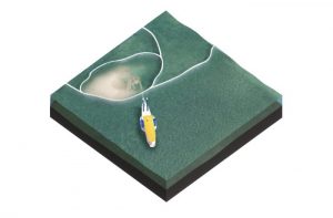
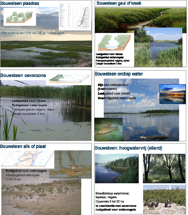
When designing islands or marshes from scratch, you can start by designing Building with Nature components (BwN-components) that constitute the important components of the preferred new system. The figure below gives as an example BwN-components for a large-scale marsh (source: Royal Haskoning DHV). In this case, each BwN-components describes the environmental conditions, key species of that specific part of a marsh and the minimum and optimum size. The final solution can be composed of different BwN-components. If the final design has to be altered, for instance due to financial constraints, some BwN-components can be adjusted or removed without destroying the integrity of the full design.
Step 5: Evaluate the BwN-components and the final design
Once you have a list with BwN-components, you can start evaluating those components. To do so, you may need to implement multiple-criteria decision-making (MCDM) or a multiple-criteria decision analysis (MCDA). The criteria in this analysis should at least include the project objectives (see Step 1). Abiotic criteria that can be used are properties such as turbidity, sedimentation, salinity, water quality, water levels, desired hydrodynamic conditions. Biotic criteria may include suitable habitat for target species, diversity in habitat and the presence of gradual transitions from the coast to the sea or lake. Other criteria may include costs, complexity, impact on the landscape, effects on cultural or natural heritage.
Depending on the project, such an evaluation can be used in multiple phases of the projects. The first step can be after the formulation of the BwN-concepts. Using the selected concepts, possible designs can be made and again be evaluated and so on, until you arrive at a final design. Implementing an evaluation scheme makes sure that you obtain a design that provides what you aim for, or at least the best solution for your project.
Step 6: Focus on reducing sediment resuspension and increasing habitat diversity
Reducing sediment resuspension
If the fine sediments are used to form new islands, one should make sure the sediment will not resuspend. Resuspension of sediment will increase the turbidity of the water and may therefore deteriorate the quality of the islands as a habitat. If the location of the island is not sheltered from currents or waves, measures need to be taken to prevent resuspension. Measures to reduce sediment resuspension are: (a) facilitate sedimentation, (b) create shelter structures with low energetic conditions to prevent erosion such as brushwood groynes and (c) permanently trap the sediment for example by means of ecoengineers.
Increasing habitat diversity
It is important to focus not only on the reduction of sediment concentrations in the water column, but also place emphasis on increasing habitat diversity. Examples of goals that increase habitat diversity can be:
- Creating an area of gradual land-water transitions: current land-water transitions are mostly abrupt and fixed with hard structures, such as dike revetments. This and the meticulously regulated (and therefore practically fixed) water level during the last decades have yielded low habitat diversity. See the restoring estuarine ecosystem in-depth page.
- Adding new nature values: for example, marshes provide suitable spawning grounds to several species of fish and nesting and resting grounds to waterfowl, reed and marsh birds.
- Improving ecological robustness: creating a more diverse habitat with high species diversity will improve the robustness of the entire ecosystem.
- Stabilizing and improving existing nature values: make sure the area can provide shelter for breeding birds and wintering birds.
- Reducing the impact or disturbance of human activities.
- Strengthening spatial diversity: offer a diverse environment with plenty of opportunities to species that are not served by other areas or projects in the vicinity.
- Land-bound predators, such as mice, rates (or snakes), can create predating issues on the islands. This has consequences for the ecosystem and the birds which breed on the islands.