Initiation
It was concluded that a solution should be found that resulted in a lower dike height. This was a chance for innovative eco-engineering design alternatives. At the same time the additional construction cost of this multifunctional design should be minimal or should even result in lower costs than the traditional design.
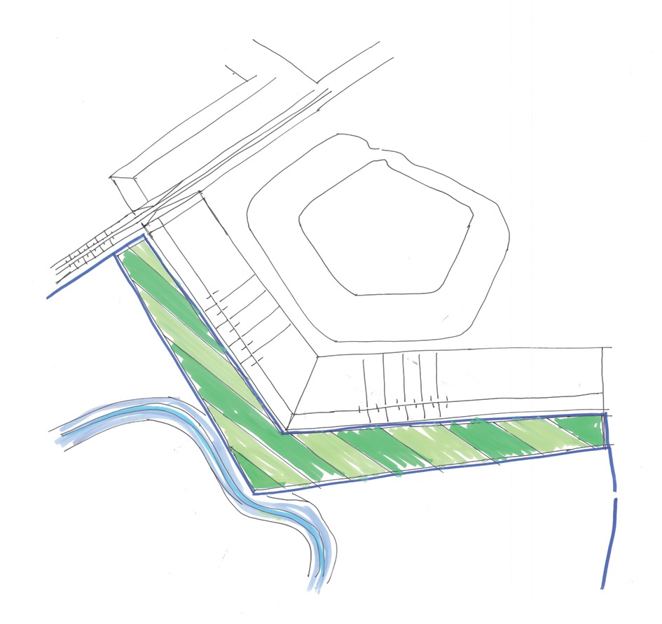
Before the project implementation started, the Noordwaard area had several functions, mainly agriculture, tourism, nature, living and some industry. As a significant part of the polder (1600 out of 2000 ha) would become flood-prone, quite some discussions and additional measures were needed to get the support of the local stakeholders. The outcome was that large parts of the agricultural area will be transformed into nature areas, housing areas will need new protection measures and tourism will be enhanced. Every function has its own stakeholders with their own interests. For many stakeholders safety against flooding has a high (if not the highest) priority. Residents of the village of Werkendam need to be protected by a new dike, but for the people actually living right behind this new dike the blocking of their view and the change of landscape were important considerations, which also reflected in their house prices. The proposal to make a higher and broader dike led to a lot of protests from the residents of Fort Steurgat because they experienced this dike as a very massive object in their neighbourhood, decreasing their pleasure of living in the area. These reflections inspired the search for other solutions.
Pre-feasibility
A design vision was made through an interactive design process of interest groups, (local)government, residents and farmers. The design had two starting points:
- At least 30 cm water level reduction at Gorinchem under design conditions (a 1/2000 per year flood event), to be maintained irrespective of future activities and functions of the Noordwaard.
- Construction and maintenance costs have to remain within the set budget.
Other aspects of interest were:
- Farmers must be able to continue their work. This relates to the frequency and the duration of inundation of their lands.
- For the present inhabitants of the Noordwaard possibilities shall be created to stay there.
Boundary conditions to the development of alternatives were:
- The characteristic natural landscape of the National Park Biesbosch, which borders the polder Noordwaard, shall be preserved and strengthened.
- The network of Natura2000 protected areas in connection with National Park Biesbosch shall be strengthened.
- The possibilities for recreation, recreational boating and canoeing, walking and cycling shall be used and enhanced, and recreational entrepreneurship shall be stimulated.
- The historical landmark Fort Steurgat shall be preserved.
- Design, exploitation and management of the area shall aim at sustaining these boundary conditions and starting points.
Feasibility
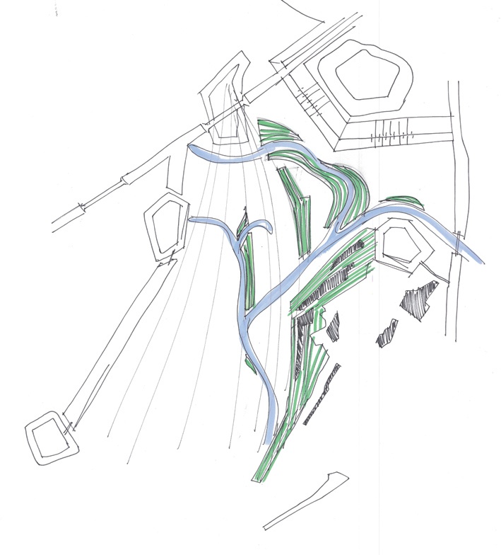
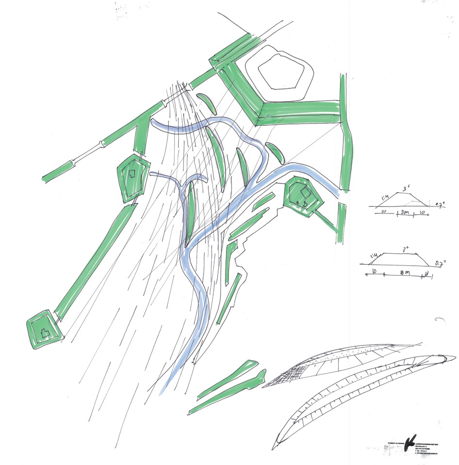
The design of the flood protection scheme for Werkendam and Fort Steurgat should focus on addressing the opposition by making the original dike design smaller. From a safety point of view, the total dike height is always composed of the design water level plus an addition to account for wave run-up and overtopping. Hence a reduction of wave height should lead to a reduction of dike height. In this specific case, the incoming wave height is considerable (1.2 m significant wave height) due to the long fetch (10 km) and the considerable water depth (3 m) under the design conditions. The aim was therefore to find a wave-reducing concept that would lead to a significant reduction of required total dike height.
During an expert meeting between the major stakeholders a number of possibilities was explored to develop a green wave-reducing dike for the protection of Fort Steurgat. Three conceptual designs were proposed:
Governance
Dikes in the Netherlands are assessed every 6 years to check whether they meet the conditions laid down in the VTV (Voorschrift Toetsen op Veiligheid: National Protocol for Safety Assessment of Dikes). The primary function of a dike is to protect the hinterland from flooding. The VTV prescribes on which failure mechanisms a dike has to be tested, given the hydrodynamic design loads (laid down for each stretch of primary flood defence in a book issued for the occasion: the Hydraulic Boundary Conditions).
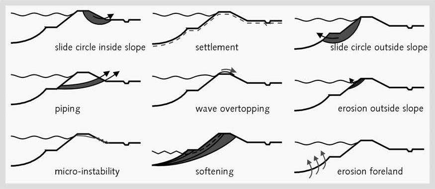
For innovative dike designs it is sometimes difficult to test the safety in conformity with the VTV, as specific rules for this new set-up remain to be formulated. On the other hand, innovative designs are based on knowledge of strength, slope, dike height. The VTV allows a way out by formulating exceptions in which testing for the required safety can be done using the best available knowledge. In this specific case, the VTV gives no rules to test the implementation of a willow forest as part of a dike design.
To ensure that the eco-friendly dike can be tested for safety, Venema et al., (2013) have designed a testing scheme providing guidelines on testing, monitoring and maintenance of the dike. This new safety testing scheme has been approved by ENW-Techniek, the national Expert group for Water Safety in the Netherlands, and could possibly serve as a basis for the implementation of such innovative designs into the VTV.
In order to get a fully accepted innovative design, relevant testing steps for vegetation as integral part of a dike will have to be designed and included into future new releases of the VTV.
Proof of concept
To determine the effect of a vegetation field on the wave conditions at the foot of the dike the numerical wave model SWAN is adapted by adding a vegetation module. The model results, in which vegetation was schematically represented, show that for the 1/2000 per year event the reduction of the wave height is between 60 to 80%. Therefore, waves up to 0.35 meter can be expected at the dike of Fort Steurgat. Details are described in the report of Dekker and de Vries (2009).