Experience
Coastline intervention tool – Holland Coast (ITHC)
The Interactive Design Tool for the Holland Coast (ITHC) is an interactive group modelling – MapTable application aiming at assisting decision makers, project developers and stakeholders in the early development stages of coastal maintenance strategies for the Holland Coast. The ITHC is a platform for interaction of knowledge from different disciplines (coastal engineering, marine & dune ecology, ecosystem services, cost-benefit analysis) and people with different roles in the development process (policy makers, stakeholders, professionals). It can be used to gain insight into the effects of human interventions and changes in environmental conditions (such as sea level rise), as well as their interactions with user functions. In this way it facilitates interaction between eco-dynamic project developers and stakeholders.
Sand Engine – IJsselmeer Coast
Initially local stakeholders were not involved in the planning and design of this project, but it soon became clear that without local support it was difficult to implement the sand nourishments. The involvement of local stakeholders in planning and design proved essential. Also locals could contribute with detailed local knowledge on historic and current morphological behavior of the coast.
Rehabilitation of a mangrove-mud coast in Timbul Sloko
In the Building with Nature programme in Demak, stable (restored) mangrove coastlines are built that reduce flood risk, erosion and saline intrusion and can adapt to sea level rise. Local stakeholders – including communities – are involved in design, construction and maintenance of measures. Simultaneously a multi-stakeholder approach is taken for the introduction of sustainable multi-functional land uses that enables inclusive economic growth once the coastline is stable.
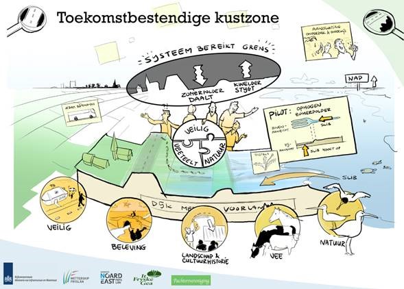
Coalition Building along the Friesland Waddencoast
In the BE SAFE project the participatory coalition building instrument ‘added value of joint action’ was applied in the Fryslân coastal area ‘Noard Fryslân Bûtendyks’. In this area, an improved flood risk reduction strategy was explored including the vegetated foreshore areas that are located in front of the dike. As these foreshores are owned, management and used by nature organizations, farmers and recreants, a multi-stakeholder approach was required. The application of ‘added value of joint action’ resulted in a shared vision of the stakeholders and a joint pilot initiative.
Governance for sustainable restoration – Veluwe Randmeren
The Veluwerandmeren were formed after the land reclamation of the eastern part of the province of Flevoland. It is a diverse but fragile area with a variety of functions. The project Veluwerandmeren is initiated in 1996 to integrate different legislation and plans for the area and is a cooperation between 19 governmental agencies. The facilitation of the process and the involvement of a wide range of stakeholders is perceived as one of the strong points of the project. Hundreds of citizens, entrepreneurs, stakeholder organizations and decision makers shared their opinions which resulted in a strong focus on the future of the Veluwerandmeren. Here you find an extensive description of the approach and the lessons learned.
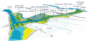
IJsseldelta south (by-pass Kampen)
To the southwest of the Dutch town of Kampen, in the province of Overijssel and bordering Lake IJssel (IJsselmeer), a new river branch was designed to cope with increasing water discharges in the Dutch Rhine branches. The creation of this new branch for flood safety is combined with other developments such as housing, infrastructure, recreation as well as nature development. This is integrated into the large-scale integral development project IJsseldelta-South.
Planning and design started in 2004; the final plan has been approved in the summer of 2012. An intensive participation process was part of the design process. The resulting plan largely coincides with the former sea-arm “de Reeve” and includes large-scale nature development. Overall, the plans have a high level of “nature inclusive” thinking in them and nature itself is considered essential for making the project a success. The processes of knowledge development and spatial design were closely connected throughout the project. This led to a Masterplan that was understood and accepted by all participants. Main insights are described in this paper.