Planning and design
A complete planning and design for this project was made by the Proponent, after a design competition in cooperation with a Consortium of Consultants and Contractors. The design includes multiple Building with Nature aspects, for example water quality improvement through filtering by reed.
Concept
The water management in the polder Wieringenmeer is under pressure due to sea level rise. For water management purposes fresh run-off water is presently discharged into the Wadden Sea during low tide. As sea level rises and the lake level remains unaltered, less discharge time will become available. Climate change is also expected to come with higher precipitation peaks, which means more rainfall in a shorter time span and more excess water to be discharged. These factors will put the system under pressure and water levels in the polders may occasionally rise to an undesirable extent.
A member of the provincial parliament (Dutch: Provinciale Staten) already suggested to create a peripheral lake between the former island Wieringen and the polder to improve the water management in 1989. Such a lake can be used for temporary storage of excess water and at the same time restore some of the original features of the area.
Pre-feasibility
After the first feasibility studies, the Projectbureau Wieringerrandmeer was installed in 2002. This organization was founded by the province of Noord-Holland, the municipalities Wieringen and Wieringermeer and the Water Board (Dutch: Hoogheemraadschap) Hollands Noorderkwartier.
Traditionally, the Water Board would try to find a purely technical solution to the problem. This would require new and larger pumping stations, designed for the peak discharge. The high costs made this approach economically not feasible and a more integral approach was chosen with three main goals:
- Socio-economic development of the Noordkop (the northernmost part of the province’s mainland)
- Nature development
- Improved water management
The motto of this project is: “blue and green delivering new economy”, in which blue stands for water and green for nature. The ‘old’ economy is mostly agricultural. The ‘new’ economy will also involve tourism and recreation (permanent or temporary), for which nature and recreational areas are needed.
The first task of the Project Bureau was to carry out a pre-feasibility study, encompassing the following phases:
- Understanding the system (physical, socio-economical and governance)
The Bureau gained knowledge about the area and its re-development opportunities by literature studies and meetings with residents, experts, directorates and entrepreneurs. Also (semi) governmental institutions explained their policy for the area and frequently shared information. A cycling tour through the area was organized by local residents for the employees of the bureau and citizens could comment on the project via a website.
- Identifying realistic alternatives
On the basis of a landscape analysis, the bureau developed general ideas about the scope of the project. This process included several thematic explorations, which revealed opportunities for each theme: nature, infrastructure, water, recreation, housing and agriculture. Several concepts were drawn up, showing which options were available. On this basis conclusions were drawn, in cooperation with experts, about the possible and desirable ambitions for this area.
- Valuating the qualities of alternatives and pre-select an integral solution
Subsequently, these ambitions were made more concrete by elaborating them for nine locations around the lake. For each of these locations one or more ideas were generated which represented the qualitative and quantitative ambitions for this location. They showed which developments were promising and how developments could be combined. For these location-specific ideas the project bureau has extended the scope of the project beyond the limits of the current policies. The results were presented to directors, experts, residents and entrepreneurs. These location-specific ideas were meant to serve as an inspiration to project developers.
Design competition
Subsequently, the Project Bureau organized a design competition in which five consortia participated. One of the objectives of this competition was that private parties would jointly take responsibility early on in the project.
The main criteria by which the designs were evaluated referred to the ability to meet the main goals of the project:
- Attract younger people to the area with sufficient employment possibilities and an attractive environment to live in;
- Improve the water management in the area;
- Achieve a richer and more natural ecological state;
- Improve the accessibility of the area over water.
The winner of the competition was the consortium Lago Wirense.
Design Governance
After the competition, negotiations started in order to draw up an agreement of intent between the public and private parties involved. This agreement was never signed, because the Municipality Council of Wieringen objected against it. The main reason for this was the lack of involvement of the council. Yet, the development of the project continued, the objectives of the municipality of Wieringen were discussed and the design of the project was adjusted. This resulted early 2007 in a Co-operation Agreement between public parties (the provincial government and municipalities) and private parties (Boskalis and Volker Wessels) for the development of the Wieringerrandmeer.
From 2007 on the organizational structure had three layers; the steering committee, the project management team and working groups. The steering committee had monthly meetings and took the strategic decisions. The members of the steering committee signed the Co-operation Agreement. The daily project management execution was in the hands of the project management team, which had five members and an independent chairman. The project management team had the task to deal with the detailed design of the project and the communication with all stakeholders. Furthermore, three working groups were established, one on the legal conditions, one on ground acquisition and one on spatial planning procedures.
Feasibility
- Valuating the qualities of alternatives and pre-select and integral solution
In the feasibility phase an Integral Impact Assessment was needed. This assessment consisted of:
- a Strategic Environmental Assessment (SEA), including a notification of intent to produce a project level Environmental Impact Assessment (EIA)
- an Agricultural Impact Assessment (AIA)
- a Nature Examination, including an Appropriate Assessment of the impacts on a number of specific species,
- a Societal Cost-Benefit Analysis (SCBA)
- Socio-economic impact study
The studies yielded three alternatives for developing the area, thus giving the authorities a solid basis to partly revise the Provincial Structure Plan and the Inter-Municipal Structure Vision. A project level EIA was drawn up for the overall plan, including the second phase of the AIA and a deepening of the Nature Examination and the water management study.
Design
The design includes multiple Building with Nature aspects, for example water quality improvement through filtering by reed. Reed filters nutrients such as phosphate, out of the water and as a result there is less food available for algae.
The design of the lake included deeper and shallower areas, with deep water in the middle sections as a buffer against saline seepage water, and shallow water near the edge, to reduce the wave run up on the dikes. Moreover, this bed profile stimulates wind-driven circulations and horizontal mixing of the lake.
To make the lake suitable for recreation the probability of occurrence of cyanobacteria (blauwalg) had to be reduced and preferably avoided. This could be achieved by regularly flushing the peripheral lake with fresh water from the adjacent IJsselmeer. The housing islands were aligned with the prevailing flow direction, such that no stagnant water would occur.
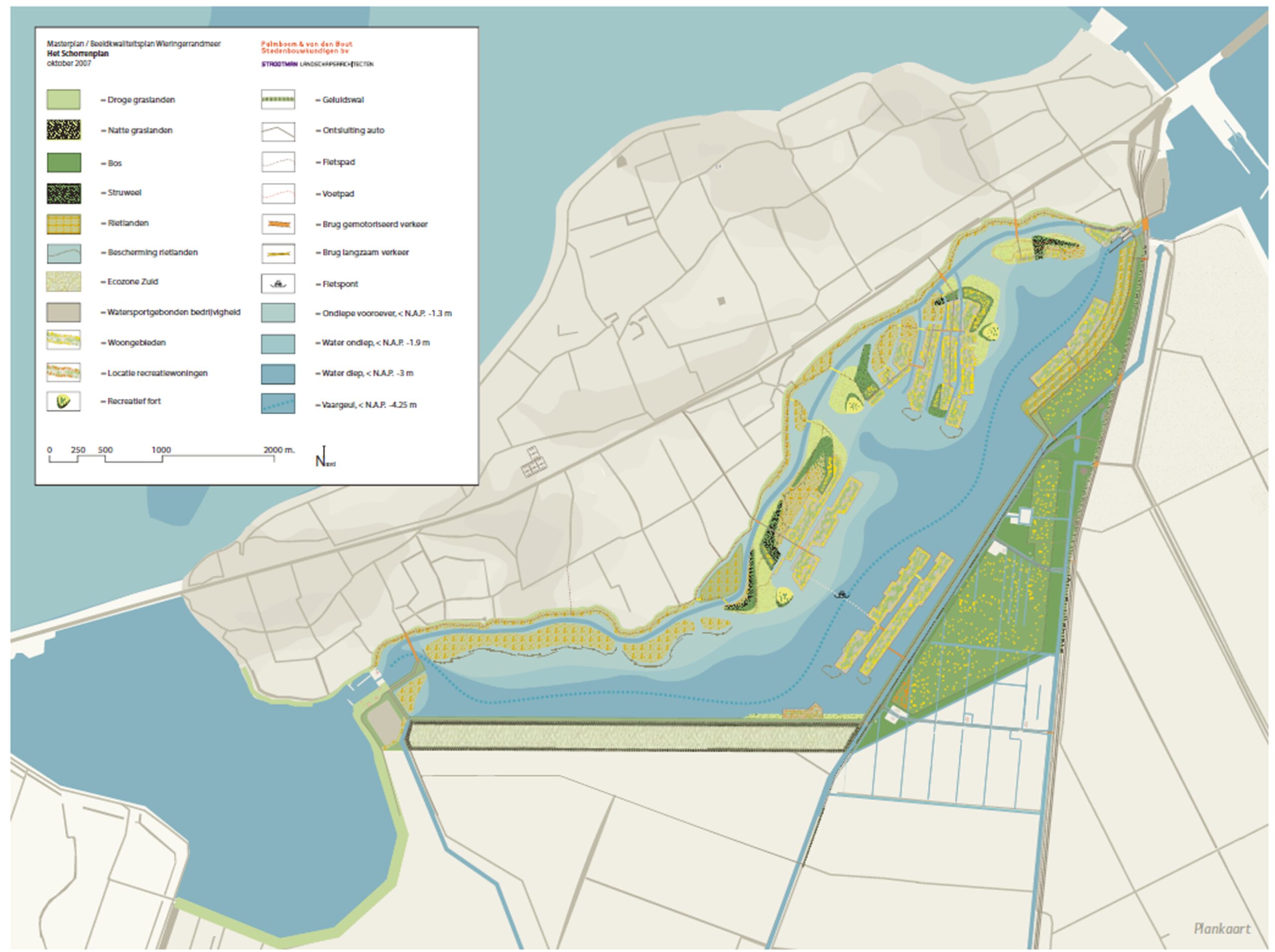
Remains of an ancient seaweed dike (wierdijk) still exist at the south side of the previous island Wieringen. In the old days seaweed was cultivated in this area. It was used as mattress filling and to build dikes consisting of poles with seaweed dumped in between. At the back of the dike sand is placed to support the structure.
This dike, being the last one of its kind in the Netherlands, has cultural historic value and people thought it would be nice to restore it. As knowledge about the construction and maintenance of these dikes is no longer available, the actual load on the restored dike should be as small as possible.
A solution was found in a large shallow foreshore of at least 35 m width. The foreshore, which is vegetated with reed, for instance, can be an area of high nature value and at the same time reduces the wave attack on the dike. Large stretches of shallow water and reed beds were foreseen in the northern part of the lake and integrated into the Noordboog, an ambitious ecological corridor project between the IJsselmeer and the North Sea.
In the planning phase, important input was provided by comprehensive aquatic and ecological analyses and modelling to determine the probabilities of algal growth and of clear plant-rich water. Also the effects of salinity intrusion into the lake were examined.
A fresh/salt groundwater flow model was used to obtain a picture of the lake’s effects on seepage, groundwater levels and salinity intrusion. This complex study provided insight into situations where fresh and salt groundwater occur simultaneously. The consequences for agriculture and nature were investigated by making additional calculations from the unsaturated zone to the fresh/salt profile in the rooting zone. These hydrological effects were being translated to revenue losses for agriculture due to flooding and salt stress, and to the ecological condition for different types of ecosystem services.
This modelling enabled optimising the water management system for coping with the increased salinity pressure. Moreover, the studies helped identifying the lake’s effects on fish migration and how the Wieringerrandmeer might play a role in creating a fresh/salt water gradient from the IJsselmeer to the Wadden Sea near Den Helder, via the Amstelmeer and the Balgzand Canal.
Planning
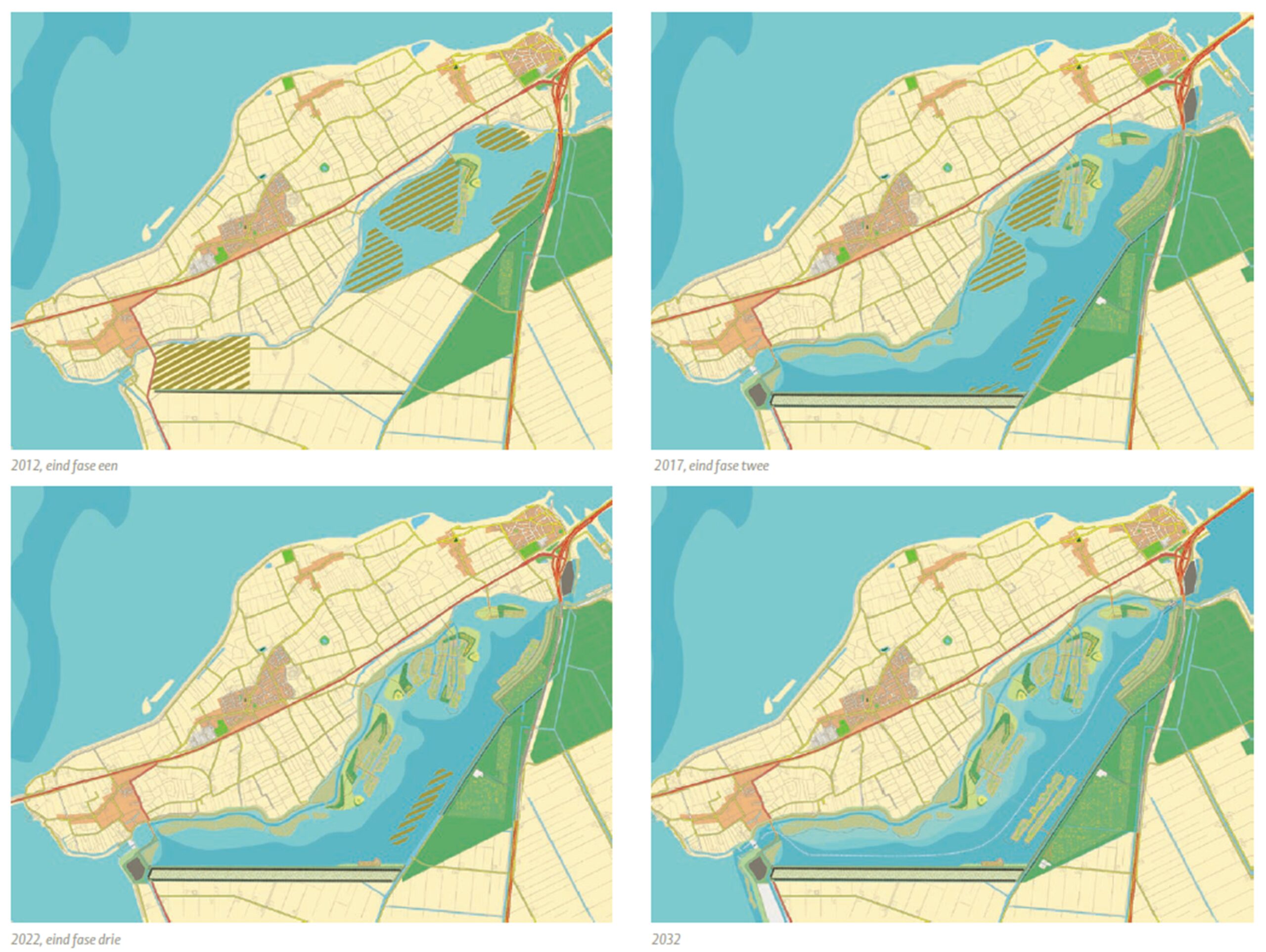
Given the economic situation, the project was planned to be built in steps. Construction work should have started in 2011, after the preparatory and planning phases had been completed.
The constructions works were planned in 5 steps, to be executed between 2011 and 2030. The first four steps are shown in the figure. First the area was to be prepared and the necessary infrastructural works were to be built. Subsequently, the peripheral lake would be dredged. The third step was to create the recreational spaces and the fourth to connect the lake to the adjacent water bodies (IJsselmeer and Amstelmeer). The last step would be the longer-term development of infrastructure and the ecosystem.
In every stage new residential areas were to be developed in order to finance the project.
- Preparing the solution for implementation in the next phase
Up to this point in time, the Waterboard had hardly participated in the design process. Because of the large impact of the project, they thought the Province and the Municipalities should be in the lead. Once the design had been decided on, however, the Waterboard would assess the water management and water quality aspects of the design, as these pertain to their primary responsibilities. .
Due to the inability of the parties involved to agree on a financing schedule, the project has now been shelved. It is not sure whether it will ever be re-initiated.