Adaptive management, monitoring and maintenance: Marker Wadden
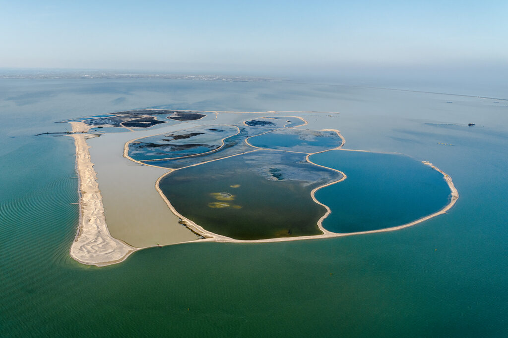
The archipelago ‘Marker Wadden’ comprises several man made islands inside the Markermeer, a lake of approximately 700 km2 located in the Netherlands. This island group of about 1250 hectares was constructed inside the freshwater lake using locally sourced sediment. The construction material mainly consisted of fine sediment and smaller amounts of sand and clay.
The Marker Wadden were designed to solve turbidity issues inside the Markermeer and to add value for nature and recreation. The turbidity issues resulted from the very fine sludge on the bottom of the lake that was brought into suspension by wind generated currents. These high concentrations of suspended sediment had negative effects on the ecosystem of the Markermeer: fish, aquatic plants and shellfish struggled to survive. This in turn had consequences for the food supply for migratory birds.
In the upcoming sections the natural, technical and social uncertainties of this BwN case are discussed and we highlight how these uncertainties were dealt with.
Natural uncertainties
For the Marker Wadden, habitat development was a key source of uncertainty in the natural system. The question was not only: how would (construction of) the Marken Wadden affect the existing aquatic habitats, due to a changing silt and nutrient balance in the Markermeer? But also, how fast and to what extent would the silt islands successfully develop into new habitat?
It was anticipated that the removal of sludge from the Markermeer and the construction of the Marker Wadden would reduce turbidity in the lake, resulting in improved living and settlement conditions for aquatic plants, phytoplankton, zooplankton, benthic and pelagic macrofauna and fish and waterfowl. In the design phase, it was less clear to what extent the desired reduction in turbidity levels would be realized and which mechanisms, other than the suspension of sediments, affected the formation of suitable habitat conditions. This was partially because the phosphate balance of the Markermeer was not fully known. Therefore, it was also difficult to quantify effects of the measures on aspects such as habitat diversity and the amount of biomass present in the Markermeer. It was also expected that habitat would develop at the Marker Wadden itself. The islands would create a sheltered area on its leeside, which could be favourable conditions for rapid habitat development. More than 20,000 rhizomes of reeds were planted by hand, to ensure sludge stability before removing the sand dikes and allowing interaction between the Markermeer and the mudflats itself. The main uncertainty during this design step was whether the reeds rhizomes would grow enough before winter time, since foraging geese could influence the habitat development.
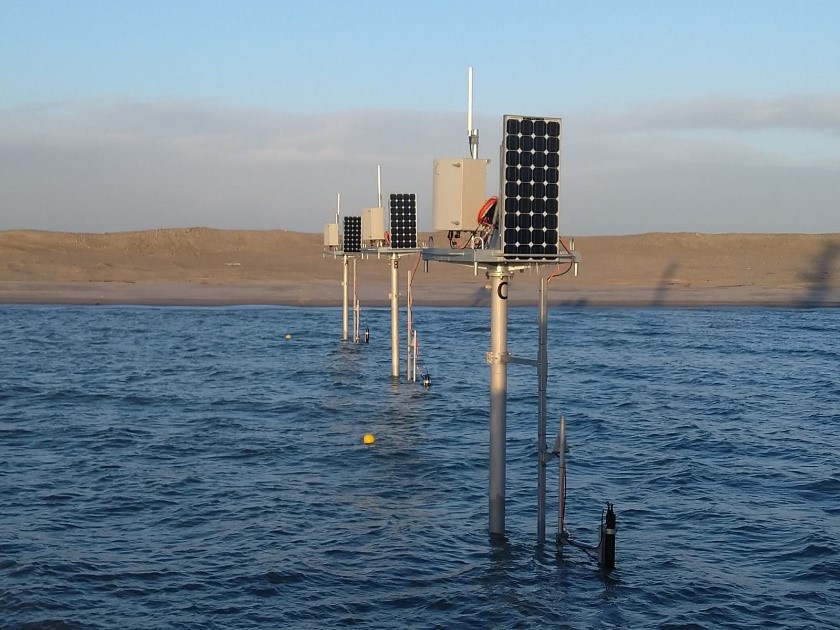
Given the uncertainties in the nutrient and ecological balance of the Marker Wadden, existing and new monitoring campaigns were employed to support adaptive management of the system. During these campaigns, parameters such as sludge concentration, turbidity and oxygen levels were measured. Also fauna were monitored, including amongst others monthly bird counting’s from an airplane and on-site bird monitoring by volunteers. Fortunately for the development of the Marker Wadden, the growth of the pioneering vegetation was at a higher rate than the food required for the geese.
Technical uncertainties
The technical uncertainties of the Marker Wadden project revolved around the question how effectively the silt islands would retain silt. The performance of the Marker Wadden as a solution for turbidity issues in the Markermeer is highly dependent on the retention of silt in the leeside of the islands. In the preparation phase of this project, a silt model was applied to estimate the retainment of silt by the islands. This model showed a large bandwidth around the results, indicating a high degree of uncertainty in the effectiveness of silt retention. A silt retention monitoring campaign in the early stages was proposed to deal with this uncertainty, as affected the degree by which the turbidity issues and thereby the ecological status of the Markermeer could be improved by the Building with Nature solution. The obtained data could be used to calibrate and validate the silt model in the early stages of the natural development of the Marken Wadden. In addition, the influence of vegetation and mussels on the sediment mobility and island erosion is a poorly understood phenomenon. This too contributed to the uncertainty of the final performance of the Marker Wadden.
Social uncertainties
As the Marker Wadden was designed to contribute to both natural and recreational values, negative interactions between these two domains could occur. For example, recreational visits to the islands could disturb the present wildlife, especially breeding birds. Furthermore, there was uncertainty in how the recreation would develop, in terms of quantity and quality.
Finally, the adaptive approach of the project created uncertainty around the timing and amounts of budget needed for implementation. The total cost for constructing the Marker Wadden was estimated to be 75 million euros. The first 50 million euros was contributed by five different parties. To avoid uncertainty in the ability of partners to provide the agreed funding when needed, a monetary fund was set up. This was a robust strategy for handling uncertainty in the implementation, operation and maintenance of the project over time.
References
- Baars, P. (2020, October 5). Marker Wadden, Creatieve financiële structuur voor innovatief project. Retrieved from:
https://www.nationaalgroenfonds.nl/projecten/project-markerwadden - Natuurmonumenten, 2013. Marker Wadden, Notitie Reikwijdte en Detailniveau.
- Natuurmonumenten (2020, September 1). Het project Marker Wadden. Retrieved from: https://www.natuurmonumenten.nl/projecten/marker-wadden/projectbeschrijving
- Rijkswaterstaat, 2014. Milieueffectenrapprot ‘Eerste Fase Marker Wadden. Projectplan Waterwet, Vergunning Ontgrondingswet en Vergunning Natuurbeschermingswet 1998. MD-AF20141283
- Zwier, M. (2020, October 6). Marker Wadden. Retrieved from: https://www.gea-geologie.nl/college-van-de-maand/college-van-de-maand-markerwadden2?highlight=WyJtYXJrZXIiLCJ3YWRkZW4iLCJtYXJrZXIgd2FkZGVuIl0=