Adaptive management, monitoring and maintenance: Rehabiliation of mangrove coast Demak, Indonesia
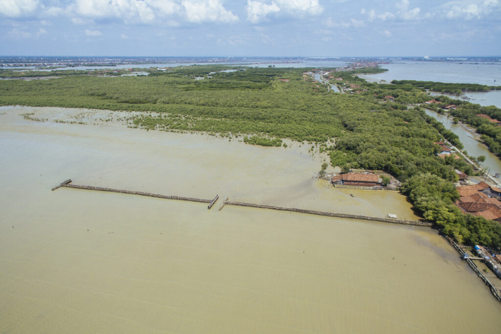
The body of scientific literature that shows mangroves help reduce coastal flood hazards is increasing. However, over the last decades mangrove habitat is shrinking at an alarming rate. Along the northern deltaic shorelines of Java, the main drivers of mangrove loss are land use change, groundwater extraction and infrastructure development. Mangrove loss is especially prevalent in poor rural communities, where they must deal with an ever increasing severity and frequency of inundation events and loss of valuable land. As part of a large pilot study, a Building with Nature approach was designed in the Demak province, aiming to restore coastal safety through the restoration of mangroves. The pilot focused on enhancing the natural recruitment of fringe mangrove communities, i.e. the Avicennia species. The BwN design used permeable structures, made of bamboo attenuate incoming waves to prevent erosion of sediment. The bamboo structures create abiotic conditions that are favorable for mangrove seedling settlement and can be removed once the settled seedlings start to develop into a new forest.
Natural uncertainties
There is ample evidence showing that fringing mangrove habitats contribute to coastal flood risk reduction (McIvor et al. 2012). They do so by reducing wave height and increasing shore elevation. As waves enter the first 100 meters of a mangrove forest wave height is diminished by 13-66%, and after 500 meters reduction can reach levels of 50-99% (McIvor et al. 2012). Furthermore, bed elevation is seen to increase between 1-10 mm per year, and historical evidence shows that mangrove systems can keep up with sea level rise (McIvor et al. 2013). While it is recognized that restoring mangrove habitat is beneficial for coastal flood risk reduction, the actual act of restoration is riddled with uncertainties (Naohiro et al., 2012). Restoring mangroves is mainly constrained by physical conditions, such as sediment availability, sediment bulk density, hydrological connectivity and wave forcing and is highly dependent on the local situation. Even without human interference, mangrove greenbelt systems are dynamic and oscillate around an equilibrium. Furthermore, sea level rise combined with high rates of subsidence in Demak, made it very uncertain if the structures would be able to elevate the bed to sufficient heights. To address uncertainties local and international experts were consulted and a 4 year monitoring program and adaptive management strategy was set in place. Eventually the monitoring program was led to better informed decision making. Resources were diverted, and efforts focused on engaging in policy dialogues that addressed the high subsidence rates driven by ground water extraction.
Technical uncertainties
There is evidence that permeable structures can reduce wave height, trap sediment and create conditions that are favorable for mangrove establishment (Van Cuong et al. 2015a). However, whether a structure would have comparable results in Demak was uncertain. Each coastline is environmentally unique, and the specific design of the structures had never been tested before. To address these uncertainties changes in bed elevation and mangrove count were monitored near the structures for 4 years. Results indicate that the structures can elevate the bed on average by 20 – 30 cm within 12 weeks and that maintenance and location of the structures influences maximum elevation. Furthermore, results show that seedlings survive at locations where sediment can consolidate.
Permeable structures are a type of BwN measure to restore mangrove habitat. In turn, mangrove habitat can be used as a BwN measure to reduce coastal flood risk. Despite evidence of their effectiveness, reluctance remains to incorporate mangroves as part of a flood defense design. Grey infrastructure, such as dykes and levees have strict design guidelines and clear knowledge of the boundary conditions under which they can prevent coastal flooding, so far mangroves do not. This lack of strict parameterization is a major source of uncertainty but one that can be addressed. Just like with grey infrastructure, mangroves can be overdesigned (a robust strategy). And while climate change may complicate the use of historical projects and data to design for the future, a BwN design can take this into account. However, many policy makers and coastal engineers are not aware that BwN can deliver robust designs. Such uncertainties stem from a lack of knowledge and were addressed during multiple training events held at national and regional Indonesian government agencies. The participants were informed that mangrove belts can also cope with the flood impacts of large storm surges by creating mangrove belts that are thousands of meters (overdesign).
Then there are uncertainties related to the “operation” or maintenance of mangrove systems. When mangroves are in the process of being restored there is a time lag before risk reducing conditions are reached, e.g. density, height and width. In the interim, a hybrid intervention can provide the necessary safety measures to bridge the time gap. Hereby the limitation of green infrastructure is effectively addressed by incorporating traditional grey infrastructure in the BwN design. For example, while waiting for mangrove forests to grow to a state in which they can reduce future projected risks, current risks can be reduced with the construction of a dyke. Such hybrid designs were discussed with Indonesian policy makers, and eventually accepted as a viable measures.
Social uncertainties
To ensure sustainable implementation of BwN measures in governance and planning, they must be implemented with consideration for the local and institutional context. Most countries do not have standard procedures, mechanisms and structures in place for BwN measures, unlike for grey measures. BwN measures are multi-functional by nature and thus require cooperation between institutions. This leads to uncertainty as to which governing body is responsible for the implementation, maintenance and operation of a BwN measure. For example, restoring mangroves can help reduce flood risk, enlarge natural habitat, become a source of tourism and recreation, revitalize fish populations, and is a natural source of wood which can be used for fires or construction. All these benefits extend into the mandates of different ministries and agencies. Because there are no organizational procedures in place that address responsibilities and cooperation between ministries on BwN measures, implementation is hampered. In Demak, addressing these uncertainties was carried out via extensive stakeholder consultations, using both top-down and bottom-up strategies. This project served as a flagship and was used to initiate policy dialogues at the national scale in Indonesia. Here the aim was to showcase the benefits and success of a BwN solution and thus foster the uptake of BwN solutions in policy, planning and enhance cooperation.
At the local scale different uncertainties hamper the uptake of BwN measures. For mangrove restoration efforts to be successful in Demak, many farmers and fishers had to allow their land to be converted to mangrove habitat. Their reluctance to participate in land reforms stems from the uncertainty of whether they would benefit and when the benefits would come. These valid concerns for farmers’ only form of livelihood had to be addressed seriously. However, the financial benefits of mangrove restoration (Ben Brown and Ratna Fadillah, 2013) were communicated by deploying a local field school and multiple training events. These training events were crucial in explaining how mangrove restoration will benefit local landowners by increasing fisheries and aquaculture yield, and also making theirhomes less vulnerable to flooding.
References
Ben Brown, Ratna Fadillah, Yusran Nurdin, Iona Soulsby and Rio Ahmad, CASE STUDY: Community Based Ecological Mangrove Rehabilitation (CBEMR) in Indonesia, S.A.P.I.EN.S , 7.2 | 2014,
McIvor, A.L., Möller, I., Spencer, T. and Spalding. M. 2012. Reduction of wind and swell waves by mangroves. Natural Coastal Protection Series: Report 1. Cambridge Coastal Research Unit Working Paper 40. Published by The Nature Conservancy and Wetlands International. 27 pages. ISSN 2050- 7941
McIvor, A.L., Spencer, T., Möller, I. and Spalding. M. 2013. The response of mangrove soil surface elevation to sea level rise. Natural Coastal Protection Series: Report 3. Cambridge Coastal Research Unit Working Paper 42. Published by The Nature Conservancy and Wetlands International. 59 pages. ISSN 2050-7941.
Naohiro, M., Putth, S., Keiyo, M., 2012. Mangrove rehabilitation on highly eroded coastal shorelines at Samut Sakhon, Thailand. Int. J. Ecol. 2012, 1–11.