Adaptive management, monitoring and maintenance: Werven Park
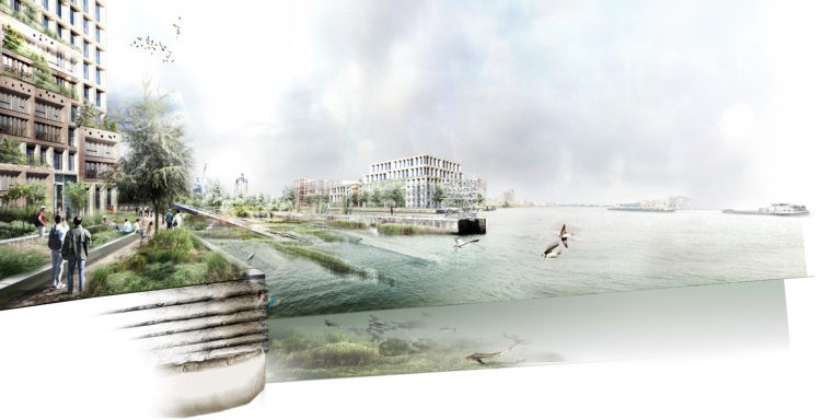
The Werven Park in Dordrecht is being transformed into a Tidal Park: a nature reserve similar to nearby Biesbosch National Park, resulting in the creation of more space for nature and leisure in the city. The Werven Park is located within freshwater tidal area, just north of the dikes of the island of Dordrecht at the busy navigated Beneden Merwede. The river banks of the area are influenced by daily tidal differences (of about 30cm) and related dynamics in sedimentation deposition and erosion, both being key factors influencing vegetation development in the area. The river banks used to be paved with large concrete slabs that stop nature development.
The City of Dordrecht has decided to remove the slabs in order to give reeds, rushes and willows more opportunities to grow. These plants will form a new habitat for birds, fish, amphibians and insects. Part of the concrete structure will be left in place and, with the reeds, rushes and willows, protect the shore from the impact of the waves and prevent erosion. The park will be a tidal area, creating a natural ‘stepping stone’ to the Biesbosch National Park, promoting natural diversity in the area and attracting more insects, birds and bats. The park will also include a walking trail and playing facilities. Visitors will be able to experience the changing tides of the Merwede River.
Here, we address uncertainties in the natural, technical and social aspects of the project that played a role in this particular BwN case and show how the project team addressed these matters throughout the different phases of the project.
Natural uncertainties
For the Werven Park, key uncertainties from the natural system concerned vegetation development within the area and how this would be affected by the local hydro-morphological conditions. Hydro-morphological dynamics, such as the current, tidal amplitude and sediment regime, are important drivers for vegetation development and succession in this freshwater tidal area. During the planning and design phase, it was generally clear what kind of species composition was likely to develop in the area, given the known hydro-morphological conditions in the area. However, it was unpredictable how dynamic these conditions specifically would be and exactly where and when these hydro-morphological dynamics would manifest in the area.
For example, changes in the river discharge could alter expected accretion rates and accordingly affect the location and type of vegetation development. When designing the tidal-park, a central question was thus, how to accommodate such unpredictable (future) conditions in the design? Monitoring vegetation development in the different vegetation zones was considered important for dealing with these uncertainties around vegetation development in the area. The monitoring results could inform an adaptive management strategy for the park that contributes to steering vegetation development into the desirable direction in the long term.
Technical uncertainties
A source of technical uncertainty that arose in the planning and design phase, was related to the waves generated by passing ships on their way to Rotterdam harbor. To what extent would waves affect the potential of the area to become a tidal-park? Would the tidal-nature envisioned for the park be able to settle and survive in the violence of the waves and the erosion they cause? More specifically, would the erosion affect vegetation development and succession over time? Pioneering plant species in the intertidal zone play an important role in the settling of sand and accordingly the growth of sandbanks, thereby also creating settlement opportunities of other species. Yet, waves generated by passing ships would result in dynamic water conditions and may cause erosion that washes the vegetation away. The chosen strategy to handle this uncertainty was to implement foreshore and other structures in front of the vegetated shoreline of the park to reduce currents and waves.
Social uncertainties
During the planning and design of the park, uncertainty regarding future spatial planning and management of the greater area played a role. The design option for natural shore protection were affected by uncertainty around long term ambitions for the nearby harbour. One of the earlier explored design options for the shoreline was to construct dead tree trunks as ‘underwater dam’ along the shoreline of the harbour next to the Wervenpark. These dams were intended to break waves in front of the vegetated shoreline and at the same time serve as living area for fauna. However, due to uncertainty around the future of the harbour, this design option was excluded. It was furthermore uncertain whether in the future the Haringvliet sluices will be managed differently, which will affect the hydro-morphological conditions and vegetation growth in the area, in the long-term.
The effects of different management strategies of the Haringvliet sluices have been researched and predictions have been made how vegetation development within the area may look under different management scenarios of the freshwater tidal area. Yet, these predications are subject to uncertainties around the accuracy of underlying data and unpredictability regarding actual response of vegetation. These models and natural dynamics thus also brought in uncertainties around long-term conditions and vegetation development.
Another uncertainty with its source in the social and natural system was whether the ‘natural’ appearance and dynamics of the tidal zone would be appreciated or considered sloppy management by park users. Especially in the pioneering phase, the vegetation in the park may be considered of limited esthetical value. People might have a response about the value of the area which is much quicker than the time it takes for the park to develop. To reduce this value-based uncertainty it was therefore decided to consult local residents and employ an accelerated strategy for vegetation development: bringing in seeds through cuttings from management activities elsewhere, in the Biesbosch, rather than waiting for the seeds to arrive over time via the river. Also, parts of the area will be mowed, to show that maintenance is being carried out.
References
van Geest, Gerben; De Jong, Barend; Moinier, Sophie (2016). Opzet monitoringsplan voor ecologische meerwaarde van het Wervenpark in Dordrecht. Kenmerk 1208238-001-BGS0002. Ecoshape-rapport opgesteld door Deltares en Witteveen+Bos.
de Jong, Barend; van Geest, Gerben (2015). Bouwen met de Natuur: Systeemanalyse Stadwerven Dordrecht, Achtergronddocument, EcoShape-rapport opgesteld door Deltares en Witteveen+Bos.
Van der Meulen, E.S., Hommes, S., 2015. Evaluatie BwN showcase Dordrecht, Stadswerven. Deltares, rapportnummer 1208238-000-BGS-0006. http://publications.deltares.nl/1208238_000.pdf