4.Restoring ecological states
The ecological status of many delta lakes has deteriorated over the last couple of decades, due to anthropogenic and/or natural causes. Several strategies can be chosen to help restoring their ecological quality. Using the Building with Nature philosophy, we look for integrated solutions whereby infrastructure is planned, designed and operated whilst creating new opportunities for nature and at the same time utilising natural forces whenever possible.
In this chapter we describe Building with Nature measures that address two major issues in lake Markermeer: high turbidity and associated ecological degradation. Of course, these problems cannot be considered separately, they are closely linked. The paragraphs below draw upon ongoing – and often unpublished – research in the frameworks of the studies ‘Autonome Neergaande Trend (ANT, Autonomous Downward Trend) and ‘Natuurlijk(er) Markermeer – IJmeer’ (NMIJ, More Natural Markermeer – IJmeer).
Reducing sediment resuspension in lakes
The availability of sediment in relatively shallow parts of a lake, combined with strong wave and current action, may result in turbid waters. Without any intervention, this sediment would be suspended over and over again. Removing sediment from a turbid system – or at least preventing it from getting suspended – can initiate a chain of events that breaches the turbidity cycle described above. Sediment reducing measures enhance light transmission at certain places, which favours the establishment of aquatic vegetation that may bring the ecosystem into a stable clear state. Three measures to reduce the sediment lakes are described below:
- sediment trapping;
- shelter structures;
- sediment capping.
1) Sediment traps
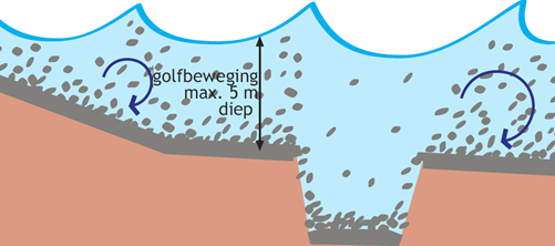
Dredging parts of the lake bed and thereby creating deeper zones where the fluffy material can accumulate may help reducing sediment availability (adjacent figure). Once settled in these sediment traps, where wave and current action is less, the sediment has the opportunity to consolidate and become less erodible. This measure has been applied in the lake Markermeer as part of the Marker Wadden project.
Different designs can be considered, such as one large trap in the middle of the lake, a gully close to the shore, a series of pits, or pits in combination with shelter zones. The impact on the sediment content depends strongly on location and design of the pit(s).
Three aspects need to be considered in relation to the location and design of a sediment trap:
- Effectiveness for sediment capture. Focusing on the primary objective of reducing suspended sediment concentrations, a combination of pits with shelter structures may well be the most effective option. Sediment-trapping can be constructed in the ‘supply routes’ of sediment-laden water to a natural or man-made depression in the lake bed.
- Ecological aspects. Based on ecological criteria one can draw a suitability map for sediment traps. One aspect to be considered is that in pits of more than 8 to 10 m deep the water will get stratified during the summer season. This temperature stratification often leads to anoxic conditions in the deeper parts, which has a large effect on fauna. When in the winter season the water gets mixed, again, the deep pits can provide wintering habitat for fish species. Preliminary computations show that in the close vicinity of the pit visibility nearly always improves, with a noticeable effect up to 3 km downstream. If algae growth is light-limited, algal blooms may occur in the clearer water, but it is also possible for zooplankton to flourish. Piscivorous birds that rely on eye sight can profit from the newly created gradients. The effect on bottom-dwelling species is less clear.
- Hydrological consequences. Depending on the location, creating sediment pits can have severe hydrological consequences for the surrounding area. For example, creating a pit in lake Markermeer with a depth of ten to fifteen meters could impair the integrity of specific water-impermeable soil layers. This could affect ground water tables, and therefore indirectly increase seepage in a region far beyond the lake’s edge.
- Cost-effectiveness. The most cost-effective locations are often found near sites where sand or clay is needed. As time progresses the created depressions will gradually fill up with sediment. It was shown that depending on local conditions, sediment traps can fill up rapidly in lake Markermeer – the smaller ones up to 2 m per year (Natuurmonumenten 2012). Removing the accumulated sediment may therefore involve considerable and recurring costs.
2) Shelter structures
The primary objective of shelter structures is to reduce sediment concentrations in specific parts of a lake. They function in two fundamentally different ways:
- By acting as a breakwater structure reducing wave action, a sheltering structure can reduce resuspension of sediment in its lee; and
- By guiding currents, the structure can divert currents and reduce the transport of suspended solids from the open water into the sheltered area. If applied on a large enough scale, applying this measure can influence the current and transport patterns in the entire lake.
A sheltering measure should not only reduce local resuspension, but also the influx of suspended solids in order to be successful. Like other turbidity-reducing measures, shelter structures may serve multiple purposes. If successful in reducing turbidity, aquatic vegetation is enabled to recover, which results in a better and more diverse food supply for waterfowl. The submerged vegetation will eventually provide habitat and spawning grounds for fish, which will attract pescivores. The effect on the sediment concentration in the lee of a shelter structure can be considerable, and – if constructed in the right location – it can serve a large area. Impact size and impact area are determined by location, positioning, shape and local hydrological conditions.
the areas with low turbidity.
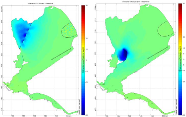
The adjacent figure shows the results of a model study on the effects of different shelter structures – in this case a series of islands or a large dam – on the turbidity of the Markermeer (Visser and Vijverberg, 2010). It shows the outcome of a model study on the impact of small islands (left) or a large dam (right) in the Markermeer. The colours represent the change in water turbidity as a result of the structures, ranging from red (high turbidity) to blue (low turbidity) (Visser and Vijverberg, 2010). This figure shows that location, size and shape are important factors determining the effect of shelter structures. Analysis has shown that these types of structures can be effectively applied all over lake Markermeer. However – as the structures aim at increasing transparency and therefore improving the ecological status of parts of the lake – the most interesting locations can be found in the more shallow zones where waters are already less turbid.
The Markermeer – IJmeer area already has a number of shelter structures (Gouwzee, Hoornse Hop, Pampushaven, Muiden, ice breakers along the Houtribdijk, breakwaters Oostvaardersdijk and natural developments in lake Eemmeer). They can provide valuable information on their effects. Monitoring of turbidity, aquatic vegetation, zoobenthos and fish species in these sheltered areas has shown that water transparency is good and that submerged vegetation often flourishes, providing habitat to fish. Vegetation composition heavily depends on the depth gradient in combination with water turbidity. Mussel populations settle usually in deeper parts with less vegetation. The sheltered zones are used as resting or breeding areas by several bird species.
Like many shallow lakes in densely populated delta areas, the Markermeer area is not only valuable for its nature: recreation is also an important factor. Abundance of aquatic vegetation can cause a conflict of interest with recreation like sailing and surfing. Others do not want the open character of the area to be disrupted by – for example – trees growing on small islands. Therefore it is recommended to try and combine shelter structures with recreational facilities like boat docks or small restaurants. Such combinations can increase public appreciation and support for these measures. Another option, of course, is to create submerged structures, which can have a similar effect on turbidity, but are not visible at the water surface. But even then, aquatic vegetation may still be a problem for boating and surfing activities.
3) Sediment capping
Another way of reducing sediment concentrations is by covering the source with a less fluffy substrate. This can have two major impacts:
- By capping the sediment, the source of sediment is isolated and kept from continuous resuspension. Capping also prevents the creation of new fluffy material by erosion or bioturbation of the clayey lake bed.
- An additional positive effect is that a less fluffy substrate improves habitat suitability for mussels (Kleijn et al. 2006).
In theory capping is a very effective measure to reduce turbidity, especially if the entire lake is tackled at the same time. From a more practical perspective, however, this measure is difficult to execute. The sheer size of most delta lakes makes it impossible to construct the cap everywhere at the same time, which means that a capped area will soon be covered with fine sediment from the vicinity. On top of that, the costs of such a system-wide measure would be large. From a technical and financial perspective, sediment capping in delta lakes is therefore not feasible.
Yet, smaller parts of a lake could be suitable for capping, especially areas that are sheltered from sediment input from the vicinity. Sediment capping in these parts can cut off the local source of turbidity and improve local conditions. Local-scale sediment capping may lead to drastic changes of the local ecosystem. Some species will disappear, while others may flourish. It is believed that sediment capping with a sandy layer will have a net positive impact on ecosystem quality, especially for mussels (Klijn et al., 2006).
Increasing habitat diversity
In creating robust lake ecosystems, besides focusing on reducing sediment concentrations in the water column, it is possible to focus on increasing habitat diversity. Two measures are being implemented in the Markermeer region that aim at increasing diversity and dynamics of the natural habitat of flora and fauna: creating marshes and creating foreshores. Please bear in mind that the information below was published in 2012, before the actual implementation of the projects in the Markermeer. An update will be made available soon. Until then, more information about the current projects in the Markermeer can be found on the Ecoshape website: Marker Wadden and the Houtribdike pilot project.
Creating the Markermeer marsh
One project, the Marker Wadden, aims to restore the ecological value of the Markermeer is the creation of a large marsh close to the Houtribdijk, the dam separating lake Markermeer from lake IIsselmeer. The goal of constructing this marsh is to create large-scale land-water transitions to increase habitat diversity. By strengthening and restoring ecosystems, one attempts to increase the lake’s attractiveness to humans as well as flora and fauna. Several sub-goals can be served by the plans:
- Creating a large area of gradual land-water transitions: current land-water transitions are mostly abrupt and fixed with hard structures, such as dike revetments. This and the meticulously regulated (and therefore practically fixed) water level during the last decades have yielded low habitat diversity.
- Adding new nature values: marshes provide suitable spawning grounds to several species of fish and nesting and resting grounds to waterfowl, reed and marsh birds.
- Improving ecological robustness: creating a more diverse habitat with high species diversity will improve the robustness of the entire lake ecosystem.
- Stabilizing and improving existing nature values: the marshlands will provide shelter for breeding birds and wintering birds.
- Strengthening spatial diversity: because of the large scale the marshes offer plenty of opportunity to species that are not served by the smaller-scale projects along the coast.
Design process
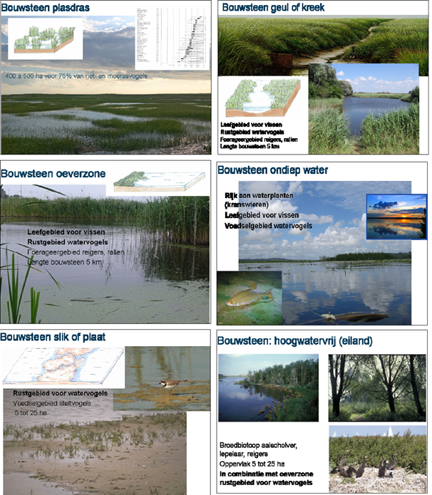
An interesting approach to design marshes from scratch is to use building blocks that constitute the important components of a large-scale marsh (see the figure below; source: Royal Haskoning DHV). Each building block describes the environmental conditions, key species of that specific part of a marsh and the minimum and optimum size. The marsh can be composed of different building blocks. If – for instance due to financial constraints – the design of the marsh has to be less ambitious, some building blocks can be adjusted or removed without destroying the integrity of the design.
Location
If a large-scale marsh is created in lake Markermeer, the ecological value of the area will increase drastically. The Houtribdijk is considered to be a good location, taking physical, ecological and political aspects into account:
- In this part of the lake the water level fluctuates most, as the prevailing south-westerly winds set up the water against the dam. This water level variation evokes dynamic processes that are beneficial to marsh development
- The dam marks the transition of lake Markermeer to lake IIsselmeer, both important foraging areas for several bird species. Improving the ecological value of the area can help support bird populations.
- As wave energy is absorbed by marsh and vegetated foreshores, wave attack on the Houtribdijk can be reduced, which saves costs of maintenance and strengthening.
- As recreation activities in this area are limited, there is less chance of conflicts with water sports.
The exact shape and location depend on many factors. Several designs have been made for a marsh area alongside the Houtribdijk, but others concern an island at some distance from the dike. Each design has different pros and cons. Based on physical, ecological and political considerations a final design needs to be made. Below arguments are listed which need to be considered when designing the marsh:
- A round shape has relatively small circumference and therefore a small area that is directly attacked by wind, waves and currents. An important disadvantage of this design is that it is more difficult to construct the marsh in phases.
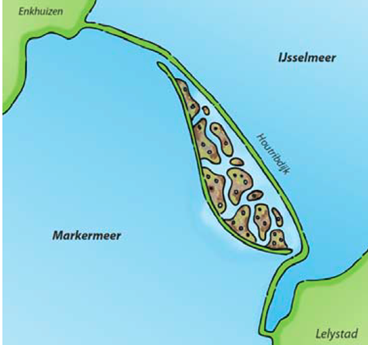
- If a more elongated marsh adjacent to the Houtribdijk is built (see the adjacent figure), the total area of the marsh and length of the shoreline can be larger against the same costs. Yet, a certain width will be needed in order to prevent external disturbances (from the dam or recreational activities).
- The location needs to be chosen such that the marsh can act as a stepping stone between other valuable nature areas.
- The northeast corner of lake Markermeer has the highest water level variation. This is important to keep the marsh healthy and to create the right environment for specific flora and fauna.
- Creating a marsh of this size can have an important impact on the sediment concentrations in the area, by extracting large amounts of fine sediment during construction, by capping part of the sediment and by diverting currents.
- A wider zone of water between the marsh and the dam would increase the sheltered area and may thus increase sedimentation in the new nature area.
- If the marsh extends alongside the Houtribdijk, it will reduce wave attack on the dike and thus the costs of maintenance and strengthening.
- When determining size and location, attention needs to be paid to the existing functions of the region, like fishing grounds or (historical) shipping routes.
Effectiveness
Creating a marsh in lake Markermeer aims at decreasing turbidity, improving the lake’s ecological status (and resilience), enhancing recreational possibilities and improving flood safety whilst at the same time reducing costs to maintain or strengthen the Houtribdijk. It is expected that this large-scale measure will be effective in achieving at least some of these goals.
The marsh will add new biotopes and habitats that are non-existent in the Markermeer nowadays. Introduction of new habitats is not for everybody acceptable. Experiences with similar sized marshes in the Oostvaardersplassen have shown that these types of measures can have an important impact on surrounding areas. The new nature area, at the crossroads between IJsselmeer, Markermeer, northwest Overijssel, Flevoland and North-Holland, will constitute an important stepping stone for various nature types, experience with the Oostvaardersplassen has taught a number of lessons to be taken into account when creating the new marsh. An important factor determining the future dynamics of the marsh is the reed growth. Large-scale destruction of budding reed by grazing geese will hamper the natural growth of the marsh. Another risk is the permanent desiccation of the marsh, which often leads to unbridled and difficult-to-control growth of willows. Nature islands created in the mouth of the River IJssel have shown willow growth to be much more successful than reed growth. By felling trees one has attempted to tip the balance towards reed growth, but one growing season allowed the willows to take over again.
The effect on turbidity in the entire region remains to be seen. To what extent creating marshes will permanently reduce sediment concentrations has not yet been calculated. Anyhow, a sheltered zone between the marsh and the dam is likely to yield clearer water there.
Another important point to keep in mind is that, if a stepwise approach is taken to create the marsh, older parts are not disturbed by building new ones. Therefore it may be wise to build out the marsh in rings, with new parts constructed from the water rather than from the existing marsh.
Ongoing research shows that the ecological improvement of the system would not be significant with a marsh with an area less than 1500 ha. Species that will flourish in such a relatively small marsh area are already well represented in the system. A larger area allows for the settlement of new species, resulting in a higher biodiversity. From an ecological perspective one may state: the bigger the better. Cost effectiveness, however, will decrease if certain ecological goals have been achieved. At the moment, it is still unclear at what area, and which costs, this point will be reached.
The budget available is probably the biggest constraint for the size of the marsh. If bought at market price, the amount of clay needed will push the budget for a marsh of about 4500 has to something in the order of 500 M€. An important cost-reducing strategy can be to make use of material remaining from other projects in the region (making work with work). This would mean, however, that projects in the area need to be co-ordinated and phase over a long period of time. Realistically, the project can only be realised if it is (partly) privately funded and can be connected to existing projects like sand extraction or strengthening of the Houtribdijk.
Creating foreshores at the Lepelaarsplassen
To increase habitat diversity of lake Markermeer, it has been suggested to create shallow foreshores in the coastal zone of the so-called Lepelaarsplassen, near the city of Almere. At this location the lake bed is rich of fine sediment, relatively deep and the shores are protected by rock revetments resulting in a low habitat value. By creating a shallow vegetated foreshore similar goals can be achieved as by creating shelter structures (see above):
- Wave attack on the flood defence system is reduced;
- Wave action on the bed is reduced, thus reducing turbidity in the lea of the foreshore;
- Currents can be guided so that sedimentation takes place at favourable locations strengthening the flood defence infrastructure; and
- New room is created for nature to develop
In the design of these foreshores, location and dimensions are important. First, the distance between the foreshore and the coastline needs to be determined. The width of the water body in between cannot be too large, in order to keep wind and wave action from getting a grip on the area and creating turbidity, again. Currents can be reduced by connecting the foreshore with the coastline at one point, either in the middle, creating two openings, or at the end, yielding one opening. Important considerations here are nutrient and water exchange and sediment input into the sheltered area.
Effectiveness
Increasing habitat diversity with mudflats, shallow reed beds and nutrient-absorbing marshes can be beneficial for species like the spoonbill, bluethroat, bearded reedling and target species of Natura2000 like diving ducks, piscivorous and herbivorous birds. The foreshore can also serve as a resting ground for waterfowl. As the area is a relatively isolated part of lake Markermeer, however, the contribution to the entire lake ecosystem will be limited.
Costs
One project, the Marker Wadden, aims to restore the ecological value of the Markermeer is the creation of a large marsh close to the Houtribdijk, the dam separating lake Markermeer from lake IIsselmeer. The goal of constructing this marsh is to create large-scale land-water transitions to increase habitat diversity. By strengthening and restoring ecosystems, one attempts to increase the lake’s attractiveness to humans as well as flora and fauna. Several sub-goals can be served by the plans:
- Creating a large area of gradual land-water transitions: current land-water transitions are mostly abrupt and fixed with hard structures, such as dike revetments. This and the meticulously regulated (and therefore practically fixed) water level during the last decades have yielded low habitat diversity.
- Adding new nature values: marshes provide suitable spawning grounds to several species of fish and nesting and resting grounds to waterfowl, reed and marsh birds.
- Improving ecological robustness: creating a more diverse habitat with high species diversity will improve the robustness of the entire lake ecosystem.
- Stabilizing and improving existing nature values: the marshlands will provide shelter for breeding birds and wintering birds.
- Strengthening spatial diversity: because of the large scale the marshes offer plenty of opportunity to species that are not served by the smaller-scale projects along the coast.
Design process
An interesting approach to design marshes from scratch is to use building blocks that constitute the important components of a large-scale marsh (see the figure below; source: Royal Haskoning DHV). Each building block describes the environmental conditions, key species of that specific part of a marsh and the minimum and optimum size. The marsh can be composed of different building blocks. If – for instance due to financial constraints – the design of the marsh has to be less ambitious, some building blocks can be adjusted or removed without destroying the integrity of the design.
Location
If a large-scale marsh is created in lake Markermeer, the ecological value of the area will increase drastically. The Houtribdijk is considered to be a good location, taking physical, ecological and political aspects into account:
- In this part of the lake the water level fluctuates most, as the prevailing south-westerly winds set up the water against the dam. This water level variation evokes dynamic processes that are beneficial to marsh development
- The dam marks the transition of lake Markermeer to lake IIsselmeer, both important foraging areas for several bird species. Improving the ecological value of the area can help support bird populations.
- As wave energy is absorbed by marsh and vegetated foreshores, wave attack on the Houtribdijk can be reduced, which saves costs of maintenance and strengthening.
- As recreation activities in this area are limited, there is less chance of conflicts with water sports.
The exact shape and location depend on many factors. Several designs have been made for a marsh area alongside the Houtribdijk, but others concern an island at some distance from the dike. Each design has different pros and cons. Based on physical, ecological and political considerations a final design needs to be made. Below arguments are listed which need to be considered when designing the marsh:
- A round shape has relatively small circumference and therefore a small area that is directly attacked by wind, waves and currents. An important disadvantage of this design is that it is more difficult to construct the marsh in phases.
- If a more elongated marsh adjacent to the Houtribdijk is built (see the adjacent figure), the total area of the marsh and length of the shoreline can be larger against the same costs. Yet, a certain width will be needed in order to prevent external disturbances (from the dam or recreational activities).
- The location needs to be chosen such that the marsh can act as a stepping stone between other valuable nature areas.
- The northeast corner of lake Markermeer has the highest water level variation. This is important to keep the marsh healthy and to create the right environment for specific flora and fauna.
- Creating a marsh of this size can have an important impact on the sediment concentrations in the area, by extracting large amounts of fine sediment during construction, by capping part of the sediment and by diverting currents.
- A wider zone of water between the marsh and the dam would increase the sheltered area and may thus increase sedimentation in the new nature area.
- If the marsh extends alongside the Houtribdijk, it will reduce wave attack on the dike and thus the costs of maintenance and strengthening.
- When determining size and location, attention needs to be paid to the existing functions of the region, like fishing grounds or (historical) shipping routes.
Effectiveness
Creating a marsh in lake Markermeer aims at decreasing turbidity, improving the lake’s ecological status (and resilience), enhancing recreational possibilities and improving flood safety whilst at the same time reducing costs to maintain or strengthen the Houtribdijk. It is expected that this large-scale measure will be effective in achieving at least some of these goals.
The marsh will add new biotopes and habitats that are non-existent in the Markermeer nowadays. Introduction of new habitats is not for everybody acceptable. Experiences with similar sized marshes in the Oostvaardersplassen have shown that these types of measures can have an important impact on surrounding areas. The new nature area, at the crossroads between IJsselmeer, Markermeer, northwest Overijssel, Flevoland and North-Holland, will constitute an important stepping stone for various nature types, experience with the Oostvaardersplassen has taught a number of lessons to be taken into account when creating the new marsh. An important factor determining the future dynamics of the marsh is the reed growth. Large-scale destruction of budding reed by grazing geese will hamper the natural growth of the marsh. Another risk is the permanent desiccation of the marsh, which often leads to unbridled and difficult-to-control growth of willows. Nature islands created in the mouth of the River IJssel have shown willow growth to be much more successful than reed growth. By felling trees one has attempted to tip the balance towards reed growth, but one growing season allowed the willows to take over again.
The effect on turbidity in the entire region remains to be seen. To what extent creating marshes will permanently reduce sediment concentrations has not yet been calculated. Anyhow, a sheltered zone between the marsh and the dam is likely to yield clearer water there.
Another important point to keep in mind is that, if a stepwise approach is taken to create the marsh, older parts are not disturbed by building new ones. Therefore it may be wise to build out the marsh in rings, with new parts constructed from the water rather than from the existing marsh.
Ongoing research shows that the ecological improvement of the system would not be significant with a marsh with an area less than 1500 ha. Species that will flourish in such a relatively small marsh area are already well represented in the system. A larger area allows for the settlement of new species, resulting in a higher biodiversity. From an ecological perspective one may state: the bigger the better. Cost effectiveness, however, will decrease if certain ecological goals have been achieved. At the moment, it is still unclear at what area, and which costs, this point will be reached.
The budget available is probably the biggest constraint for the size of the marsh. If bought at market price, the amount of clay needed will push the budget for a marsh of about 4500 has to something in the order of 500 M€. An important cost-reducing strategy can be to make use of material remaining from other projects in the region (making work with work). This would mean, however, that projects in the area need to be co-ordinated and phase over a long period of time. Realistically, the project can only be realised if it is (partly) privately funded and can be connected to existing projects like sand extraction or strengthening of the Houtribdijk.
Creating foreshores at the Lepelaarsplassen
To increase habitat diversity of lake Markermeer, it has been suggested to create shallow foreshores in the coastal zone of the so-called Lepelaarsplassen, near the city of Almere. At this location the lake bed is rich of fine sediment, relatively deep and the shores are protected by rock revetments resulting in a low habitat value. By creating a shallow vegetated foreshore similar goals can be achieved as by creating shelter structures (see above):
- Wave attack on the flood defence system is reduced;
- Wave action on the bed is reduced, thus reducing turbidity in the lea of the foreshore;
- Currents can be guided so that sedimentation takes place at favourable locations strengthening the flood defence infrastructure; and
- New room is created for nature to develop
In the design of these foreshores, location and dimensions are important. First, the distance between the foreshore and the coastline needs to be determined. The width of the water body in between cannot be too large, in order to keep wind and wave action from getting a grip on the area and creating turbidity, again. Currents can be reduced by connecting the foreshore with the coastline at one point, either in the middle, creating two openings, or at the end, yielding one opening. Important considerations here are nutrient and water exchange and sediment input into the sheltered area.
Effectiveness
Increasing habitat diversity with mudflats, shallow reed beds and nutrient-absorbing marshes can be beneficial for species like the spoonbill, bluethroat, bearded reedling and target species of Natura2000 like diving ducks, piscivorous and herbivorous birds. The foreshore can also serve as a resting ground for waterfowl. As the area is a relatively isolated part of lake Markermeer, however, the contribution to the entire lake ecosystem will be limited.
Costs
Cost indicates for creating the foreshore vary between 50 to 150 M€, depending on size, materials used and construction methods. These costs are relatively high, due to the necessity to create a wave-breaking structure in the deepest part of lake Markermeer and the creation of shallow areas with clay. If sand is used, costs will rise quickly.