Practical Applications
The tool was developed and applied in the Building with Nature sand motors along the Frisian Ijsselmeer Coast. In this project, it was used to assess the effect of measures that were proposed during design sessions for Building with Nature measures. It contributed to the system knowledge, and exposed knowledge gaps. It also provided useful estimates of the sand transport capacity of the coastal system, which was essential knowledge to estimate the effect of interventions.
- Assessing past morphodynamical effects to previous interventions along the Frysian Ijsselmeer coast
- Assessing whether a coast is naturally eroding or prograding
- Estimating sediment transport processes, magnitudes and velocities along coasts
- Building datasets to test models
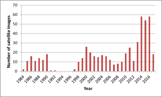
For the Frisian Coast along Lake IJsselmeer, the coastal morphodynamical changes were assessed using LandSat Imagery obtained from Google Earth Engine. The useful dataset stretched from 1984 to the present. In the area, a number of interventions were carried out to the system in the 1990’s to strengthen the coast and make it more ecologically attractive. The effects of these interventions have not been monitored intensively, and therefore are unknown.
Lake Ijsselmeer coast.
In Google Earth Engine, analyses can be performed on large satellite datasets. However, in the case of the Frisian Lake Ijsselmeer coast and especially the shallow foreshore, this turned out to be a hurdle because the morphological changes observed were difficult to define using computer code, as the colour and visibility of the foreshore sediments was dependent on water depth and turbidity. Therefore, a code was written that extracts all satellite images from the area within a rectangle with less than 10% cloud cover. The images were automatically given the name of the recording date, and contained information about the exact location of the images. The images could be immediately imported into a GIS system. Interestingly, it turned out that for the period between 1991 and 1997, almost no images were available. The reason for this data gap is unknown, and appears to be specific for this location.
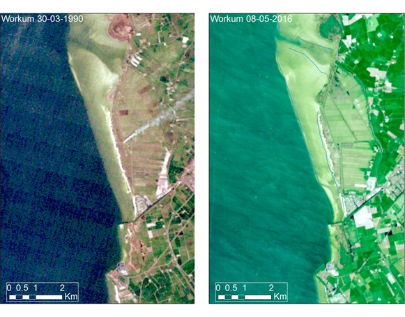
Satellite images of the area along the Workum coast in 30-03-1990 and in 08-05-2016.
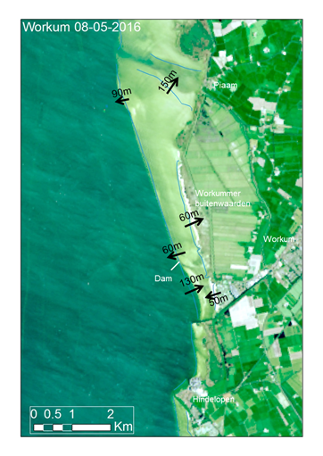
For the entire coast, subdivided into five stretches, the differences were analysed and changes were quantified. For these guidelines, the stretch near Workum is used to show the potential of the tool. The results for the coastal stretch near Workum show several significant changes between 1990 and 2016:
- The foreshore appears to prograde by 60 and 90 m in 25 years
- South of the bended dam, the foreshore has eroded 130 m. This dam was constructed 1995 and appears to be the cause for this coastal retreat.
- The shallow sandy foreshore has prograded by 150 m to the north
- The beach near Workum has prograded 60m, probably due to sand nourishments
These changes indicate sand transport to the north. In the south, the sand supply doesn’t meet the demand, and erosion takes place. The coastal stretch in between the navigation channel towards the Workum harbour and the dam is clearly affected by the construction of the dam.