Practical Applications
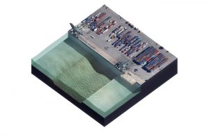
The Markermeer is a fresh water lake in Netherlands and part of the IJsselmeer area. An important aspect of the lake is the ecological value for birds, because of its food supply and shallow water. This is the reason that the IJsselmeer area is part of the Habitat and Bird regulation and is an assigned Natura2000 ecosystem. The construction of the Afsluitdijk in 1932 and the Houtribdijk in 1976 stopped the natural flushing of the lake system. The result was that during storm events large amounts of sediments are suspended into the water column and subsequently decreased the ecological value of the lake.
To provide more bird habitat and to improve the water quality of lake Markermeer, a new island group called ‘Marker Wadden’ has been constructed in the lake. The Marker Wadden has been developed to re-initiate habitat diversity by reducing turbidity in the lake. In addition to low-energetic shelter zones, also deep silt traps have been dredged, to catch the surplus of sediment in the lake. This material is subsequently also used as land fill material. When sufficient material has been trapped, it is dredged and transported to the islands. The material is placed in layers to build the Marker Wadden. The goals of the project are (Rijkswaterstaat, 2014):
- Creating a bird paradise with varying habitats for flora and fauna
- Improve the water system by immobilizing fine sediments
- Contribute to Future proof Ecological System Markermeer (TBES)
- Gain knowledge in building with mud
- Minimize maintenance costs
Mud layer and turbidity
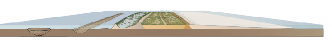
In the lower Marker Wadden bed layer Holocene clay is found. The Holocene was used for the construction of the islands. On top of the Holocene deposits in the lake are fine silt layers is found. This ‘IJsselmeer deposit’ is mainly found on the deeper eastern parts of the lake and often referred to be the fluffy layer. This layer is eroded rapidly and can result in sediment concentrations of 100-250 mg/L (average background concentration is 30mg/L). After a storm, this can drop till 50 mg/L. The ease with which the fluffy layer is re-suspended, results in varying locations of presence in the lake. In the future, the thin mud may be used for the maintenance and further development of the Marker Wadden archipelago.
Design
The pits around Marker Wadden have the following functions:
- source of Holocene clay to build the islands (during the sedimentation basin construction)
- sink for suspended fine sediment to reduce turbidity (during the basin’s lifetime)
- source for deposited mud to maintain or expand the wetlands (during the basin’s lifetime).
Source of Holocene clay to build the islands
According to Rijkswaterstaat (2014), the required amount of material in the compartments (surface 1000ha) based on initial estimates were 21.9 million cubic meters of Holocene clay and peat. The contribution of the trenches was estimated at 1.7 million cubic meters of trapped sediments. Initial estimates predicted 15 million m3 after 10 year due to the immobilization of sediment in the trenches, but also in the shelter zone of the islands.
In order to obtain this required amount of material, 2-6 sedimentation basins (120ha) was estimated. The deepest basin is around 40m. For efficient dredging cycles, the outer edge of the basin is located on maximal 3km from the edge of the compartments. The trenches are placed on sufficient distance from flood defenses (Rijkswaterstaat, 2014).
Sink for suspended fine sediment to reduce turbidity.
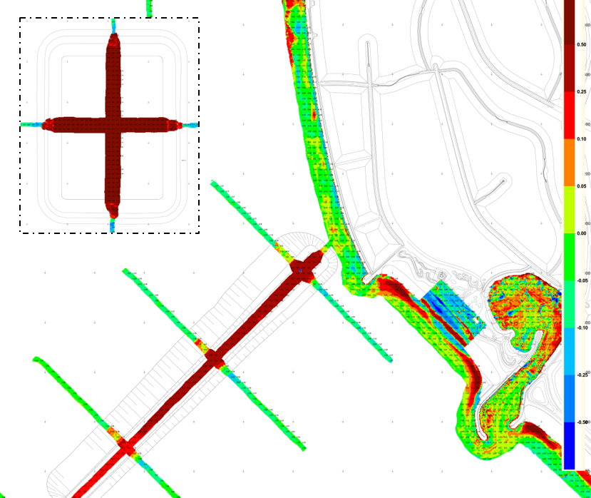
In order for the sedimentation basins to contribute to the reduction of turbidity in the lake, the sedimentation rate in the pits should be quantified and compared with the mud balance of the lake.
Three infilling locations can be distinguished 1) trench (ca. 40 cm/yr ~ 25 ha), 2) pits (ca. 80 cm/yr ~4×50 ha) and 3) low energetic zones in the proximity of the island (few cm/yr ~300 ha). A local effect on turbidity is expected, however a long-term systematic decrease in turbidity is not yet certain, because there are many physical and biological processes playing a role.
Source for deposited mud to maintain or expand the wetlands
In addition, the sedimentation rate in the pit should be quantified with the maintenance requirements of the wetlands. The deposited mud is rather ‘fluff’ whereas the mud for wetland construction will have a much higher density (after consolidation under water and ripening of the unsaturated crust above water).
Monitoring
In the knowledge and innovation program Marker Wadden (KIMA) knowledge is gathered around three topics: valuable ecosystem, adaptive governance and building with mud and sand. In the latter, the composition of the mud is investigated:
- The mud channel, pits and sheltered side: siltation rate
- The mud compartments: strength and height development, the impact of vegetation on that development
- The sandy edges: stability and exchange between the Markermeer lake and Marker Wadden
During the construction of the Marker Wadden also the siltation in the basins is monitored periodically. The infill of the sediment is coupled to the occurrence of storms. The measurements consist of layer thickness, volume, consolidation degree and density of the sediment. In addition, temperature measurements should assist the investigation on whether the basins influence the presence of smelt. The habitat developments are regularly monitored.
Based on monitoring, observed sedimentation rates range between 20 and 80 cm per yr in sedimentation channels and rectangular pits, respectively. However, the solids fraction is rather low, about 12 – 17%, resulting in a sedimentation flux in the order of 40-100 kg/m2/yr. Given a total pit area of 200ha, the equivalent consolidated sediment is 200.000 – 500.000 m3/yr. Distributed uniformly over 500 ha, this is equivalent with 4 – 10 cm/yr. These amounts are suitable for maintenance, but less for large scale building within a reasonable time frame. It is however substantial with respect to the mud balance of the Markermeer lake (net erosion = net deposition = 1000 kton/yr), even more if sedimentation at the lee side of Marker Wadden is also taken into account, which is estimated at another 200 kton/yr.