How to Use
This section describes the considerations that are relevant for the application of sedimentation basins for Building with Nature purposes: (1) turbidity reduction and (2) beneficial re-use of (fine)sediments, on the basis of the five basic steps for BwN designs. The foreseen function of sedimentation basins provides boundary conditions for the design. The feasibility of the concept is location specific and depends on the environmental conditions of the system.
Understand the system
In general, prior to Building with Nature design, the understanding of the system is key. For the physical system it is important to know the typical hydrodynamic conditions (currents, waves, discharges and resulting bed shear stresses). For this concept understanding of sediment dynamics at a local scale (near the sedimentation basin) and at system scale is at most important. In this light one should think about: sediment concentrations and fluxes, bed composition, sediment properties such as settling velocity, erodibility. If these conditions are unknown, field surveys are required to measure and gain (physical) system understanding. Without this information it is neither possible to make an initial design, nor to quantitively evaluate alternatives.
The relevant physical processes vary for the different environments. The hydrodynamic forcing in lakes is often governed by wind-generated short waves, while coastal regions encounter also swell waves and tidal currents. In estuaries hydrodynamics is influenced by the (salty) in- and outflow of the tide and by the (seasonal varying) freshwater discharge of rivers. This forcing and its underlying sediment and salinity features influences the source- and sink balance of the sediments, and hence net sedimentation in the system. Whereas the sediments are stirred up by the wind waves in (shallow) lakes, this is mainly applicable within the breaker zone of the coast. Estuarine regions may also encounter salinity-driven density currents and the formation of an estuarine turbidity maximum (ETM). The abundance or deficit of mud and/or sand within the region is also important. Mud is easily transportable. So, mud is supply limited rather than transport capacity limited. This makes hydrodynamics not the only factor for transport of fine sediments and makes sink (e.g. deep pit) and source (e.g. dumping dredged sediments) terms relatively more important.
Design alternatives
The next step can be performed once the relevant processes are determined and insight in the (fine) sediment mass balance is available. It is recommended to check the viability of a sedimentation basin before making any designs.
Goal related considerations
The requirements on the functioning of the sedimentation basin and thus the viability criteria differ per goal. Below the considerations per goal are described. Note that in practice within a Building with Nature approach not seldom multiple goals are combined resulting in multiple benefits, but also to a larger set of considerations like:
- Turbidity reduction. Important design trade-offs for this goal are the desired scale and speed of the turbidity reduction. A single strategically placed sedimentation basin might be sufficient, if the turbidity reduction should only be realized in a part of the system and within a rather long (~10 years) time span. However, it requires likely much more to reach a large turbidity reduction on a system scale within a limited time span. Upfront one should estimate with what rate sediments can be trapped in a sedimentation basin and how this amount relates to total amount of sediment exchange in the surrounding area of a sedimentation basin and at system scale, both suspended transport by advection in the water column and water-bed exchange. This provides the designer with an estimate of the required size of the sedimentation basin and the expected time span that it takes to reach a certain decrease in turbidity levels.
- Beneficial re-use of sediments. For this goal the beneficial re-use application of the (fine) sediments should be central. This application sets boundaries for the sedimentation designs, e.g. minimalization of transport distances require to construct the sedimentation basin close to the application’s location. Next, the application sets quantity requirements. For example, maintenance of a nature island requires a certain volume of sediments within a certain time frame (e.g. every couple of years). The application can also set a quality requirement. For example, maintenance of levees requires clay with a high resistance to erosion.
Design considerations
- Location. The location of a basin is mainly determined by its purpose. The largest effect on sediment concentrations takes place in the direct surroundings on the basin. For turbidity reduction this may steer the location towards the most turbid areas. For sediment extraction and beneficial re-use of sediments the type of sediments and the distance to the application location are important. In addition, the choose for a location can also be influenced by hydrological effects (e.g. impact on seepage lengths), location of existing shipping lines and excavation regulations (RHDHV2015).
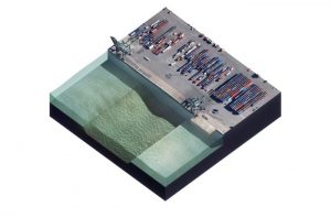
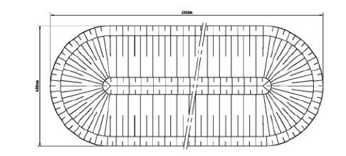
- Lay-out. Many sedimentation basin lay-outs exist. An elongated basin has typically length of a few kilometers and a width of several hundreds of meters (Figure 1A, more details in Witteveen+Bos, 2004). A cross shaped basin is a theoretical basin shape that functions well for various wind directions (Figure 1B, Vijverberg and Boderie, 2008). Round basins have been applied in the field (Figure 1C, Van den Brenk, 2002). The construction of round basins is relatively simple, because dredging can take place at a single location. The basin develops due to slope stability (Van den Brenk, 2002). Sedimentations basins can also be combined with shipping lines. These are longer compared to the elongated basins, but have often a smaller width. An example is the waterway between Amsterdam and Lemmer in the Netherlands. For all these lay-out holds (especially applicable to the deepened waterways and elongated lay-out) that sedimentations basins orientated perpendicular to the dominant flow direction are the most effective. Parallel orientated sedimentation basins attract flow resulting in more resuspension and lead to only limited or no increased deposition rates (Vijverberg and Visser, 2010).

- Area and depth. In a large sedimentation basin more sediments are likely to settle. Thus, with a focus on turbidity reduction a large basin with an intermediate is a better once compared to a very deep basin covering a limited area. A very deep basin, a pit, is commonly an artefact of sand mining. These pits have typically a depth of tens of meters, depending on the depth of the sandy layer and the required excavation volume.
The basin should be deep enough to limit resuspension of sediments that enter deeper areas. In a poorly designed basin sediments accumulate during calm conditions, but sediments are resuspended and are transported outside the basin during storm conditions. Ideally the sedimentation rate inside the pit is (almost) equal to the gross sedimentation. Knobben (2014) and Van den Brenk (2002) found a tipping depth after which the deposition rate drastically decreased. This observation is most likely due to wave induced bed shear stress that come into play at decreasing depth.
The a very deep sediment basin may result in (increased) stratification and even anaerobic conditions in deeper areas. Regarding dissolved oxygen concentrations, practice showed that the saturation percentage declines below 50% on a depth of 5 meters for pits close to shore. For pits in open waters, the boundary depth is around 20m. - Slope. Theoretically the slope influence sedimentation in the basins, because for steeper slopes density currents increases. At the other hand, in case of slopes steeper than 1:5 turbulence near the basin edge will increase. However, in practice and in model studies the effect seems rather limited (S. vd Brenk, 2002; Vijverberg, 2008; Boderie 2010).
Valuate alternatives and pre-select an integral solution
Alternative sedimentation basin design should be valuated against measurable metrics. These metrics depend on the main goal(s) of the solution. In case the sedimentation basin is estimated to provide insufficient capture of fine sediments, one should think of adding alternative measures, such as sheltered shallow areas for turbidity mitigation. The impact of the solution on other system function should be analyzed. This impact can be locally, but if the solution is large compared to the system the overall system functioning can be altered. E.g. the hydrodynamic conditions in the region can change, affecting the overall sediment transport, shipping conditions or hydrodynamic loads on levees. The questions below give guidance to check if the goals are likely to be met:
Turbidity mitigation
- What are the preferred turbidity levels?
- Given the reference turbidity levels, is it likely that the system reaches the preferred turbidity level in the set time frame?
Collection of (fine) sediments to be used beneficial
- What quality restrictions correspond to the foreseen function of the sediments (e.g. infilling material, dike strengthening)?
- How much material should be collected (e.g. relatively small volumes to counter a subsiding small island, or large volumes to be used a land-fill material)?
- In what time frame should the material be collected?
Simulating performance of alternatives
The systematic effects of alternatives are not easy to predict, especially if an alternative includes multiple trenches and/or pits. A numerical (fine) sediment model can be applied to simulate the effects of different combinations and geometries of trenches and pits. Prior to any modelling activities the system functioning should be well understood. For sedimentation basins the focus should be especially on understanding of (a) the local hydrodynamics and sediment dynamics at the concept location and (b) the sediment dynamics of the larger system. The Delft3D DELWAQ module is particularly fit to simulate fine sediment dynamics in comparison to more “traditional” sediment transport models as it includes a two-bottom layer model. The first layer consists of an easy erodible layer and a second buffer layer that only erodes during more energetic conditions (van Kessel et al., 2011).
After thorough model calibration and validation, the effectiveness of alternatives can be tested for various scenarios. This should give insight in infilling rates, spatial scale of turbidity changes (only local or systematic effects) and resuspension during more energetic conditions. These outcomes allow for further optimization of the alternatives. Next, ecological modeling can be performed to quantify environmental impacts. A well-designed building with nature solution results in benefits for both humans and nature.
Elaborate on selected alternatives
The pre-selected alternative(s) should be designed in full detail. Next, a plan should be drafted for the implementation phase. Refinement of the design might be needed due to project related restrictions. The effects on the environment should be thoroughly analyzed to obtain required permits. Depending on the local legislation aspects to analyse include: hydrodynamics, sediments (water column and bottom), water quality (light penetration, oxygen, temperature), effects on flora, fauna, fishery, shipping, recreation. Here, also feedback on the design functioning should be studied. For example, it could be that algae growth (due to increased light penetration) has a counteracting effect. An overview of effects on water quality and ecology in the Marker Wadden project is described in RHDHV (2015).
Implementation and maintenance
At least prior to construction, but ideally prior to final design, reference monitoring should be carried out to establish a benchmark. After the sedimentation basin has been dredged, it is important to measure the progress of the infill to match it with the pre-defined expectations. This entails the current situation in the water column and the soil around the potential location of the sedimentation basin.
Mud dynamics, turbidity and ecology
Monitoring of infilling rate and turbidity changes on a local and system scale. Maintenance should be carried out once the basin becomes to shallow resulting in a decline of basin effectiveness.
Re-use of the sediment
Monitoring focusses on the speed of infilling in the sedimentation basin and soil characteristics of the material (Deltares, 2016). The latter focusses on:
- Density and water content. The bulk density is determined by the weight of the sediment divided by the volume. The water content is the ratio between the weight of the water over the weight of the solid deposited material. For both it is important to obtain a soil sample which has been disturbed as less as possible
- Strength and consolidation (rate).
Extraction of sediments can be carried out once sufficient material with the right quality is collected.