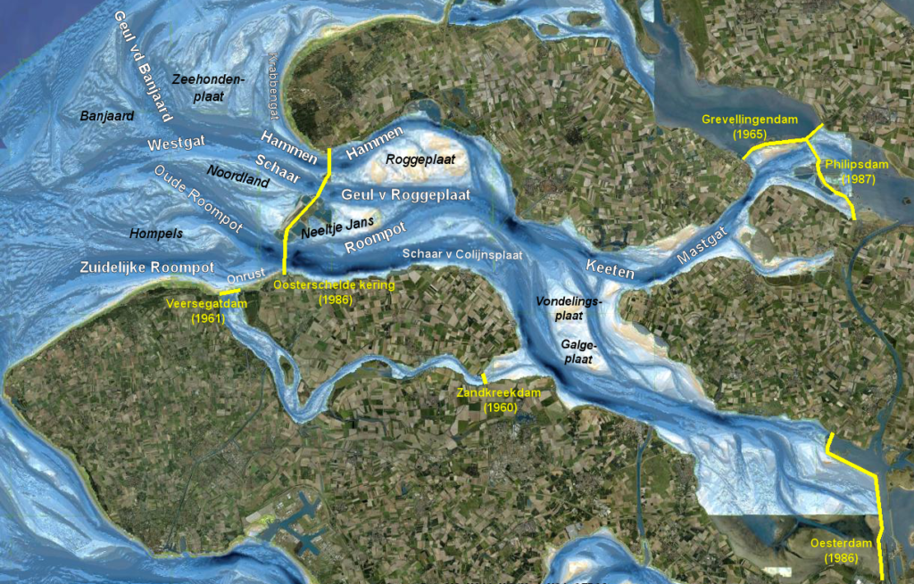
Channel-shoal interaction
The change in hydrodynamic conditions caused about by the storm surge barrier forced the estuary out of equilibrium and brought the channels in demand of sediment. This sediment is supplied by the adjacent intertidal areas inside the basin. As a result, these intertidal areas are eroding, which has unfavourable consequences for ecology, safety, shipping, recreation and fisheries.
The process governing the degradation of the Galgeplaat (in the eastern part of the Eastern Scheldt, see figure below) was found to be the combination of breaking waves and wave-induced currents. Due to the storm surge barrier the tidal flow has no longer enough shoal building capacity to counteract erosion caused by waves.
More detailed explanation of these governing processes and the influence of the storm surge barrier is described in this section, just as the possible developments based on simulations.
Governing processes
Process-based modelling showed that shoal accretion above mean low water (MLW) was possible as long as tidal characteristics in the basin were like before closure. In that situation, velocities on top of the shoal were 30 – 40 % larger than at present. Under the present conditions, the model indicates that shoal accretion does not occur. This confirms that tidal flow is responsible for the build-up of shoals and mudflats: their accretion only occurs when the tidal flow velocities are strong enough.
The process governing the degradation of the Galgeplaat was found to be the combination of breaking waves and wave-induced currents.
- During calm weather, waves break on the higher parts of the shoal (depending on wave height, local bathymetry and water level). The breaking waves lead to erosion there. When the tide falls, waves can also break on lower parts of the shoal, closer to the edges. Under these conditions, there is some redistribution of sediment on the shoal and sediment transport from the shoal into the channel.
- During storm events, wave breaking is not limited to the higher areas. The breaking waves stir up sediment and bring it into suspension. Wave-induced currents then transport this sediment from the shoal into the channels. Because breaking can occur everywhere on the shoal and no areas are sheltered, erosion is ubiquitous on the intertidal areas and can be severe. This holds for north-westerly as well as south-westerly wind conditions.
Influence of the storm surge barrier
Measured tidal currents and sediment transport on the Galgeplaat, during calm weather and spring tide, are shown in the figure (Louters et al., 1998). Before construction of the Eastern Scheldt barrier, the tidal flow was strong enough to have a significant shoal building capacity, and shoal accretion could take place under calm conditions. This shoal building effect is visible in the figure below: the velocities and sediment transports on the shoal are significantly stronger during flood than during ebb (Das, 2010). This means that more sediment is brought onto the shoal during flood than is taken away from it during ebb.
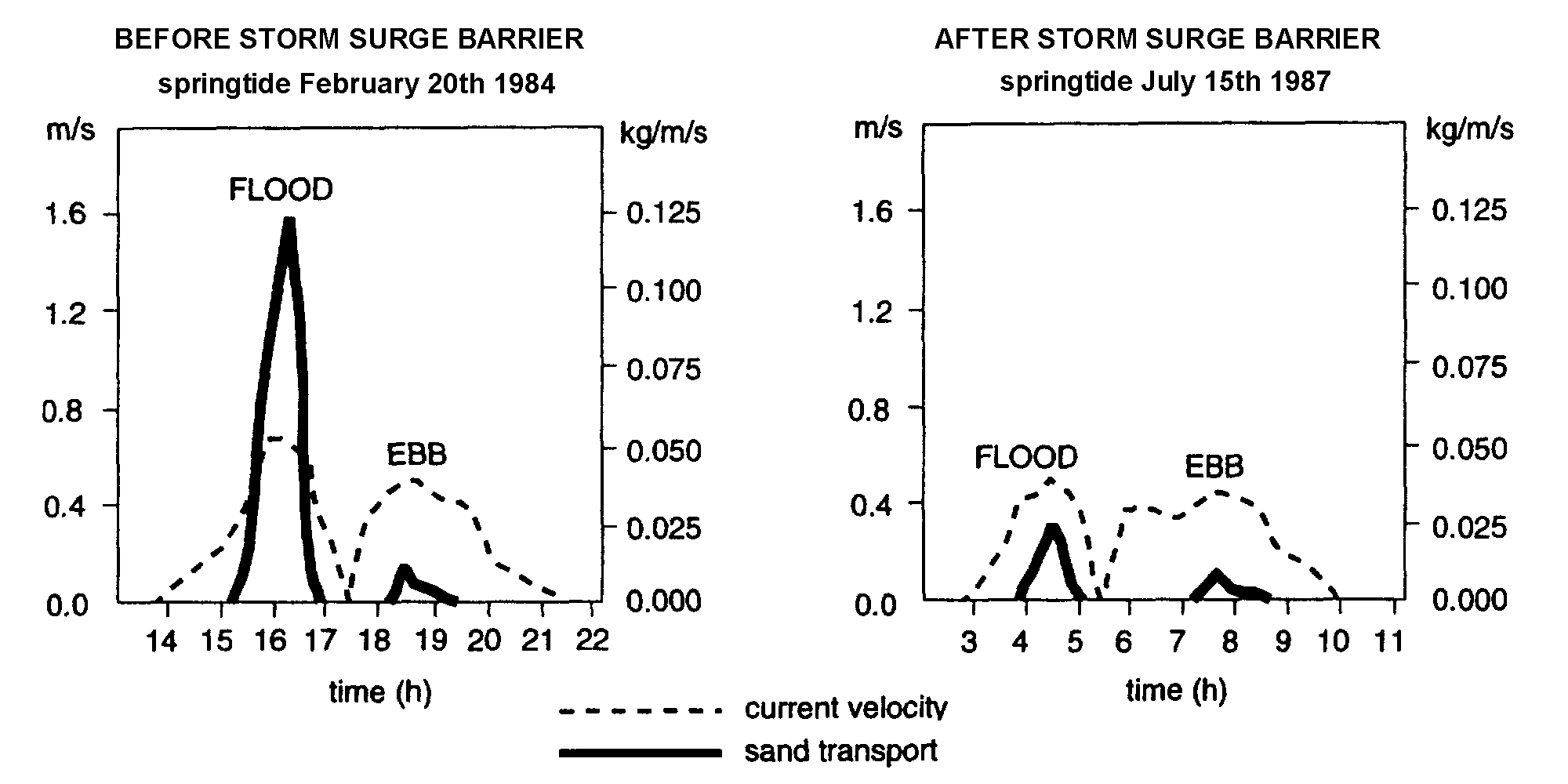
The right-hand panel shows that, due to the barrier, particularly these flood velocities and transports have reduced significantly. At present, the tidal flow in the Eastern Scheldt no longer has enough shoal building capacity to counteract the erosion caused by waves. This explanation is also supported by the observation that in the same period of time (from 1986 till present the intertidal flats in the Western Scheldt have become higher instead of lower).
Possible future developments
Simulations with different bathymetries dating from 1983 and 2008 indicate that the loss of sediment from the shoals to the channels leads to a less ebb-dominant system. Ongoing loss of sediment from the intertidal area can lead to a scenario without intertidal flats around 2100. To investigate the implications of such a scenario on the hydrodynamics, a representative situation for 2100 was simulated. In this scenario, all sediment above NAP – 2 m was removed and redistributed in the channels. This caused a stronger distortion of the vertical tide, compared to the situation in 2008, and made the system slightly flood-dominant. This flood dominance is also visible in the tidal velocities, be it that the distortion is weaker.
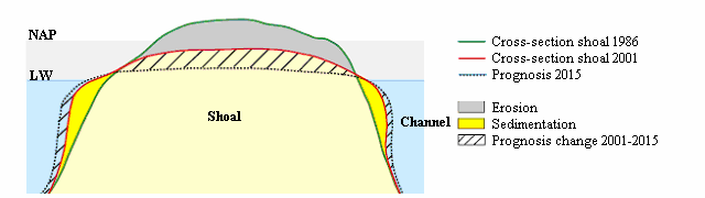
In the top figure are the profiles of a shoal visible. Erosion occurs mainly on the top of the shoal. Sedimentation occurs on the edges of the shoal, below the low-water line. The result is a net loss in intertidal area.
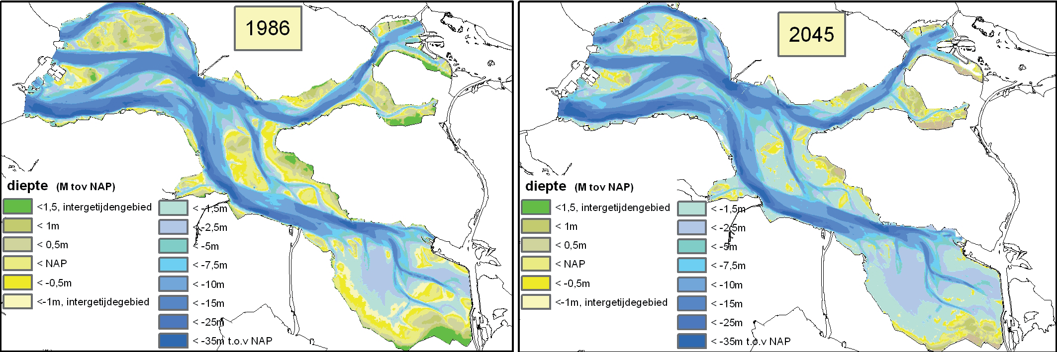
The lower figure shows two bathymetrical maps of the basin. The map on the left shows the measured bathymetry, at the time of completion of the barrier in 1986. The map on the right shows the expected bathymetry for 2045, if the present-day trends would continue. Also here, the loss in intertidal area (above MSL -1.5) is clearly visible. The eroded sediment has contributed to the area below low-water and the infilling of deeper channels.