Design and Construction
The Managed Realignment electronic platform provided a schematic picture of the total planning and design process of a Managed Realignment . All steps are mentioned in this picture (see below). The detailed descriptions can be read from the website.
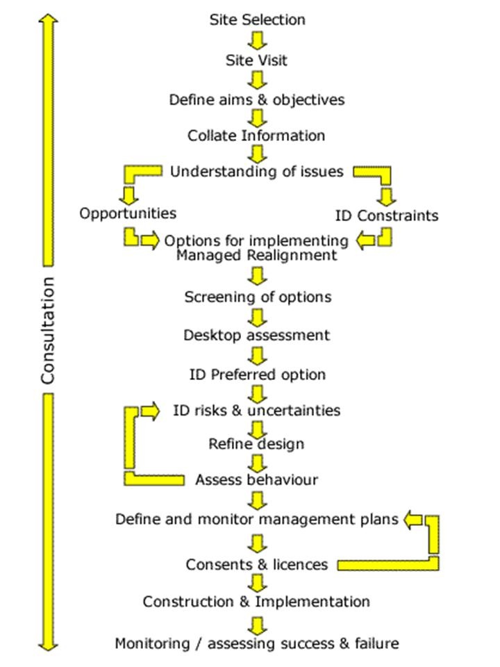
A complete overview of design issues for coastal and estuarine managed realignments is given in CIRIA (2004). This guidance is intended to disseminate knowledge on design issues for managed realignment projects by providing information on the design and management processes. It provides coastal managers and their consultants with comprehensive information on the design process and help with the practical application of this management option. As this is a extensive guideline, no further reference will be made. It is recommended to use this guidance during the whole process of managed realignment design. Some of the design steps are mentioned in more detail below.
Collate information
An important part in the planning and design phase is the data collection. Relevant baseline information is crucial for the design and implementation of a successful Managed Realignment scheme. A desk study to determine what information already exists is traditionally carried out prior to collection of any new data. The desk study should also assess the usefulness of existing data to the design or assessment of the restoration, identify gaps and effectively focus new data collection.
Areas for investigation include geomorphology and hydrodynamics, engineering characteristics, environmental characteristics and assessment, economic viability, and consents, permissions and licences.
Baseline information about coastal processes, morphology and ecology is necessary (already within the initial phase) to support potential coastal ecosystem restoration activities (Royal Haskoning, 2010). An understanding of the site and the coastal system within which it fits will:
- help to inform the initial identification of the site and its potential suitability for restoration;
- assist in the design of the restoration;
- and support the assessment of impacts of the restoration on the local and wider environments.
Below Table summarizes the key baseline data
| Areas of investigation | Parameters | Description |
|---|---|---|
| Morphology | Regional morphological environment | Satellite images, aerial photographs, land maps and marine charts can be used to gather information on large areas providing a broad-scale impression of the morphological characteristics of the coast |
| Site topography | The elevation of the restoration site relative to the tidal frame is the primary factor which determines the fate of the new wetland over the long term. If the land receives less than 300 tidal inundations a year then saltmarsh will be created. If the landreceives more than 300 tidal inundations a year then the land will turn into mud flats. Three main methods are generally adopted to collect topographic data; ground survey, photogrammetry and Laser Induced Direction and Range (LIDaR). | |
| Hydrodynamics | Water levels and tidal range | The elevation of tidal water levels relative to the topography of the site is important for wetland development. If the tidal inundation is too high or too low it can restrict habitat development. Tidal asymmetry will influence the net import/export of sediment in the estuary. |
| Wave action | Collection of wave data enables assessments to be made of the degree of exposure of the potential restoration site to wave action, and hence the potential for inhibiting deposition and for re-suspension of deposited sediments. Waves influences erosion and deposition. Wave energy must be below the level that erodes saltmarsh. | |
| Sediments | Sediment composition | Sediment composition and distribution at and adjacent to the site can be evaluated through a campaign of surface and sub-surface sampling followed by laboratory analysis. |
| Suspended sediment concentrations | Monitoring suspended sediment concentrations is important in the analysis of morphological change in wetland environments. There must be enough sediment to develop saltmarshes without harming the coastline or estuary. | |
| Ecology | An ecological assessment is important to document existing on-site and surrounding biological communities, identify environmental concerns and help define biological goals and objectives | |
| Geotechnic / soils | The geotechnical properties of the substrate in the restoration site would provide an indication of the sediment stability, shear strength and susceptibility to erosion. Soil information: The less modified the original marsh soils, the higher the success rate. Saltmarshes require fine-grained soils but not sandy soils as the lack of nitrogen inhibits plant growth. Mudflats require sand or soft mud. | |
| Contaminated land | The presence of potentially contaminated materials across the restoration site should be investigated in order to identify any constraints that may affect the design process. | |
| Water quality | Water quality measurements provide data on the health of the watershed, wetlands and lagoons in order for appropriate actions to be taken to protect and improve desired conditions. Because fish and other aquatic organisms cannot survive without oxygen, dissolved oxygen is one of the most important parameters. Other key parameters include nitrates (may stimulate excessive plant and algae growth), pH and organic carbon content. | |
| Land Ownerschip | Landowners need to be willing to give up the land. The land can be bought or compensation given. |
Boundary conditions
Once the dike is breached and the managed realigned area is subject to tidal influence, it will start to develop. Development of salt marshes is crucial for two reasons. Firstly, once salt marshes develop, large scale erosion is unlikely to occur. Salt marsh vegetation will enhance sedimentation and acreation of the area that will reduce waves and improve safety. The second reason is that managed realignment is often used as nature development and compensation measure. This is aimed at creation of saltmarshes because they are an valuable habitat that can support biodiversity and ecosystem services. The practice of managed realignment should therefore by aimed at development of salt marsh vegetation and apply to several boundary conditions in order to be succesful. These boundary conditions are elaborated in Building with Nature Concept – Managed Realignment.
Design (Royal Haskoning, 2010)
In designing a tidal wetland restoration scheme, the intent is to restore physical processes that create and sustain the particular form or structure that supports the desired wetland ecological functions. This approach should not attempt to ‘engineer’ a predetermined replicate of a tidal wetland, but should instead provide a setting for the natural evolution of wetland functions and interplay of natural ecological processes.
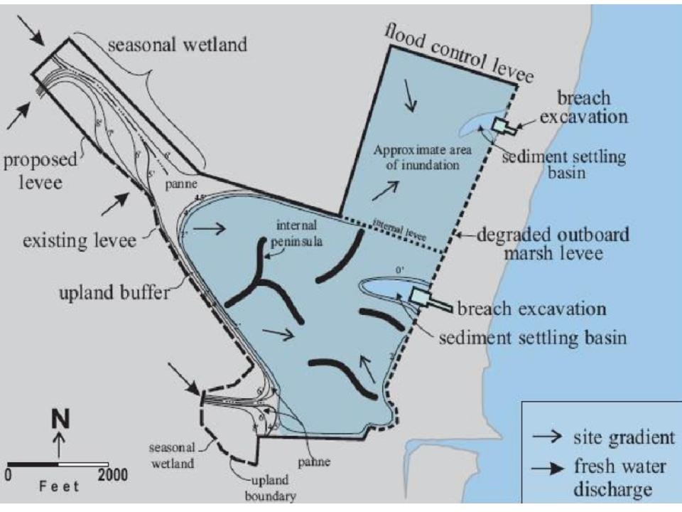
In order to take advantage of the physical processes that would allow the tidal wetland to evolve, the site is typically graded before the re-introduction of tidal action. This grading is the site template and, if appropriately designed, can steer the progress of the wetland towards maturity. The site template should aim to create conditions that allow the wetland landscape to evolve through hydrodynamic and sedimentary processes, without the need for further management intervention.
Some more design considerations are listed in ComCoast (ComCoast Brochure):
- New realigned defences – These should be designed as per the usual procedure for sea defences, using overtopping analysis and including an allowance for consequent erosion, deposition and sea level rise.
- Wave breaks – They can be used at sites vulnerable to wave action to decrease the erosion of sediment recently deposited in the intertidal area, or to decrease the erosion of the old defence.
- Creek networks – They can be left to develop naturally or can be artificially created. The latter has the advantages of increasing the distance of flow of the water and sediment so increasing sedimentation and vegetation, and aiding the drainage of water from the site. They can be formed to match old creeks identified from aerial photographs, and created with vertical sides and bends.
- Vegetation – Short vegetation or a ploughed field should be left to encourage quick establishment of new vegetation.
- Breaches – They should be placed where there are existing channels and should encourage even distribution of water over the site. They must not be open to the predominant wave direction to avoid scour and erosion. They need to be wide enough to allow the tide to exit on the ebb tide without causing negative consequences from increased flows in part of the tidal cycle. This is controlled by the velocities of the current. They may need to be very wide to achieve this. Having one breach will cause more sedimentation, but increased scour on both sides of the breach. The bed level of the breach should reflect the depth of seaward creeks, accounting for predicted changes once breached. The breach ends of earth embankments will need armouring if widening of the breaches is not desired. Breaches should be monitored and if there are problems with erosion or lack of inundation, the breach size should be increased.
- Drainage – Sluices must not be created in a location where they might silt up.
- Counterwalls – They should be constructed to protect surrounding development or sensitive areas.
Impacts – Design must spread the impacts of the managed realignment to decrease the rate of change e.g. adding sediment to an inter-tidal site if it is predicted to erode quickly. - Cost – The expense of removing or maintaining the old defence must be considered as it could prove a hazard if it is left to erode naturally.
- Navigation reasons – If modelling of the breaches is miscalculated, managed realignment could produce increased scour of the channel resulting in changes to navigation.