Overview
Please note that this website is currently not running, but the principle and method can be applied to monitor other locations.
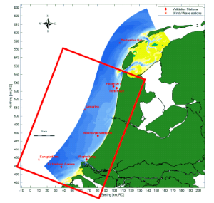
The Wave Transformation Table is a look-up table to quickly obtain elementary wave parameters (i.e. significant wave height, peak period and direction) nearshore. This information can be relevant to any type of coastal and offshore engineering or marine ecology study in which waves are important, especially if nearby wave measurements are missing, too expensive or too time-consuming. The tool is available both as a web application and as a Matlab application. The look-up table only covers the Holland Coast, but in principle the technique can be applied to nearshore areas anywhere in the world (provided that sufficiently long offshore wave time series are available).
Type: Model
Project Phase: Planning & Design
Type of assessment: Impact Assesment
Purpose: Quick assessment of wave parameters for projects affected by wave dynamics
Requirements: basic knowledge on wave modelling/ monitoring
Relevant Software: OpenEarth Viewer (web application) or Matlab (stand-alone tool)