About
Please note that this website is currently not running, but the principle and method can be applied to monitor other locations.
In the Netherlands, on average five people per year drown in the surf zone and in most cases rip currents play a role in these accidents. Rip currents can form spontaneously and suddenly in the surf zone, but they usually occur when waves break over a sand bar, water “piles up” between the bar and the beach, and flows out through gaps (rip channels) in the sand bar. Offshore directed velocities of over 1 m/s can be reached, which makes a rip current difficult to counter, even for adult swimmers. The website www.muienradar.nl provides daily predictions of swimming conditions for the beach of Egmond. The predictions are based on model computations of nearshore tidal, wind- and wave-driven currents. The prediction system provides lifeguards and beach visitors with information about the swimming conditions, with special attention to the occurrence of rip currents.
Nourishments, and especially concentrated mega-nourishments like the Delfland Sand Engine, alter the morphological state of a beach. The wind, waves and tides have full play on the sand that becomes available, leading to the development of new sandbars, rips and feeder channels. Because of the modified coastline and the new and dynamic bottom features, the currents in the nearshore zone will differ from those in the natural situation. This may lead to less safe or even unsafe situations for swimmers.
In assessing the safety of bathing conditions, lifeguards typically rely on their experience and expert judgement. The daily routine at a lifeguard post is to judge the wave and weather conditions in the morning and decide which safety measures to take for the day. Once a mega-nourishment has dramatically changed the coastal system, the lifeguards lose (part of) their largely empirical knowledge base. In addition, the position of the sandbars and rip channels changes continuously due to the strong natural dynamics. This variability further complicates beach surveillance and bathing safety assessment. Overall, the predictability of swimmer safety around a mega- nourishment can be said to be less than before, until the nourishment has spread along the coast and the coastline has become more or less straight again.
The introduction of a forecasting system for nearshore hydrodynamic conditions (partly) re-establishes the predictability of swimmer safety. It is the basis of a warning system which informs lifeguards, authorities and the public about when and where to expect dangerous currents and the associated hazard level. Sections of the beach where this level is too high can subsequently be closed off for swimmers or closely be monitored by the lifeguards. Thus, the system enables an efficient allocation of human resources, education of the public and possibly prevention of drowning accidents.
BeachWizard
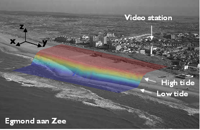
A key component in developing a reliable nearshore hydrodynamic model is the availability of local up-to-date bathymetrical data. After all, the location and strength of the type of rip currents considered herein are to a large extent governed by the shape and height of the sand bars. Routinely surveying the bathymetry, however, is a costly matter. In the present project it is attempted to derive real-time bathymetrical data from Argus video imagery. The methodology to convert Argus images into an estimate of the bathymetry is called BeachWizard and is based on analysis of the wave breaking patterns (albedo in time-exposures derived from the video images). The BeachWizard technique was previously developed and tested in manual mode for the beach of Egmond. Testing and validation of the automated operational BeachWizard system for Egmond is currently in progress. More information on BeachWizard can be found in Dongeren 2008.