Planning and design
The Planning and Design works for the Maasvlakte Sand Extraction pilot consisted of the following phases:
- Initiation phase during which the various options for ecological landscaping of the seabed have been developed and tested for their basic feasibility;
- The pre-feasibility phase in which the scientific hypothesis for the proposed solution was elaborated and substantiated;
- Feasibility phase during which the location, objectives and procedures for the pilot were established.
This pilot, set within the national coastal policy and part of a commercially running construction project, could only have been made with due attention to governance aspects.
Initiation
The increased demand for marine aggregates can lead to a growing impact on the seabed and the organisms that depend on it (macrozoobenthos and demersal fish). Traditionally, these impacts are considered to be negative, though inevitable. Therefore, permitting authorities prescribe that impacts need to be minimized in time and space (traditionally, in the Netherlands permits did not allow for extraction deeper than 2 m below the undisturbed seabed; recently, based on new understanding permits allow for deeper sand extraction, up to 20 m below the seabed).
Sand extraction sites are often selected based on economic reasons, such as the amount of suitable sediment and sailing distance. The impact on nature is considered by opting for a site with a poor to moderate ecological value. The post-dredging value of a site, however, is rarely considered. This means that opportunities for habitat enhancement through sand extraction may be missed.
Looking at these practices, from an environmental point of view there is room for improving the way that sand extraction sites are currently licensed and operated. Opportunities for ecological development can be created not only through the geographical choice of the location and the extraction depth, but also through ecosystem-based landscaping of the seabed during the sand extraction process. Current legislation and policy concerning the marine and coastal environment, however, are still based on conservation principles, rather than on ‘dynamics’ and ‘development’, and they don’t pertain to one habitat replacing another.
Pre-feasibility
A literature study supported the idea that an extraction site can be designed and operated in such a way that a good ecological status (species assemblage, high biomass and species richness) can be achieved after extraction. By taking the potential ecological response into account both during the early stages of the design phase and when determining the operational methods, enriched ecological conditions of the sand extraction site could be reached. This is especially the case if the seabed in the sand extraction site is landscaped, e.g. by creating bedforms such as large-scale sand waves or tidal ridges.
The literature study demonstrated that habitats will vary with seabed morphology, hydrodynamic conditions, water depth and sediment composition. In more detail, ecological surveys on tidal ridges and sand waves, as do occur in the subject area, showed differences in benthic community composition on the trough, slope and crest of the ridge (Baptist et al. 2006, Van Dijk et al. 2012).
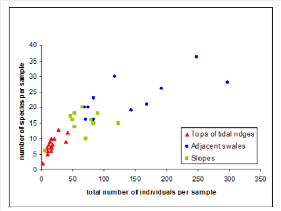
A typical species for the crests of sand waves is the crustacean Urothoe elegans and for troughs the polychaete Spiophanes bombyx . A typical species for the shoreface-connected ridge area is the polychaete Nephtys cirrosa . The swale of the shoreface-connected ridge is typified by the polychaete Eteone longa (Baptist et al. 2006).
The study of van Dijk et al. (2012) shows that marine habitats over two tidal ridges in the North Sea vary from low-density/low-diversity communities on the well-sorted sandy crests of the ridges to high-density/high-diversity communities in the poorly sorted muddy, gravelly sediments in the adjacent troughs (see figure above, Van Dijk et al. 2012).
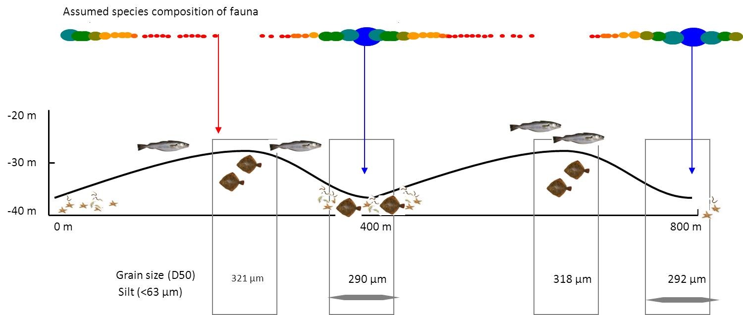
The troughs of sand waves which are characterised by fine sediment and higher mud content, biodiversity often appeared to harbour more species and a higher biomass (see figure). In turn, the macrozoobenthic communities are an important food source to other species such as flatfish.
Clearly, natural physical gradients due to the presence of bedforms have a positive effect on the overall biodiversity and biomass. Landscaping an extraction site to increase the variation in physical parameters such as morphology and hydrodynamic conditions is therefore expected to have a similar effect on the ecosystem in the area.
In consultation with marine ecologists, it was decided to test this hypothesis by incorporating this type of morphological features in an extraction site. Two pilot locations were chosen in the sand extraction site for the Maasvlakte 2 expansion. It was decided to make the gradients as large as possible to maximise any potential developments and to assess effects at the highest possible level of discrimination (accuracy and significance).
Feasibility
A desk study was carried out to determine if seabed landscaping was possible within the Dutch legislation. The study identified and analysed the opportunities and obstacles in the existing judicial and licensing framework related to sand extraction in Dutch coastal waters. Policy and legal requirements were assessed by the extent to which, and the way in which, they stimulate or impede the development of seabed landscaping, considering technical dredging aspects as well as ecological opportunities.
For the Maasvlakte 2 sand extraction site a license for sand extraction was already granted. Discussions with permitting authorities and stakeholders led to the conclusion that the landscaping could be integrated in the contractor’s working plan. If the design of the landscape remained within the general requirements and boundaries of the permit, no objections were to be expected (Lulofs, 2010).
The next step was to prepare the design of the landscaping. This was done according to the principles of Eco-Dynamic Development and Design (EDD):
- Analyse the ecosystem functioning in the designated sand extraction site and its surroundings.
- Explore options for the proposed project and try to even better integrate with other functions such as coastal defence, aquaculture, sand and gravel extraction, land reclamation, ecological development or restoration, etc.
- Explore options to use natural processes to achieve the integration mentioned under the previous point.
After defining the ecological and physical baseline conditions , the planning and design phase concentrated on optimising the landscaping design for the sand extraction site. It followed the relatively simple approach described below (Rijks, 2011):
- Requirements. These were obtained through discussions with stakeholders. It is important to translate the ideas and technical criteria into requirements which can be used in the design process.
- Design. The design process translates the requirements into a design. This is an iterative process: while the design is taking shape, the formulation of the requirements can be improved. The result of this process is the actual design.
- Verification. This is the check whether the design meets all requirements (technical, procedural, financial). If this is not the case, either the set of requirements or the design needs to be changed.
The following stakeholders were asked for their input, based on their role in the project:
- Marine ecologists: what are the physical gradients required for optimal ecological development and habitat creation?
- Morphologists: to what extent are the ecosystem-based sand bars stable and how do they compare natural bed forms tending to develop in the area after extraction?
- Contractors: how about workability and practical realization of the design?
- Authorities: to what extent can the design be realised within the existing permit and legislation structure?
Choice of pilot location
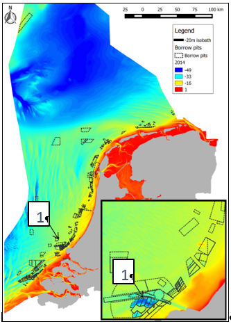
The Maasvlakte 2 sand extraction area lies about 20 km offshore from the Port of Rotterdam (PoR). The site was chosen in consultation with the project owner, the permit authority and the contractor.
The Maasvlakte 2 extraction site is the largest in the Dutch coastal area. It extends over an area of 2500 ha, has slopes of 1:7-1:10 and an extraction depth of about 20 m below the original seabed (i.e. the seabed is lowered to NAP -40 and -44 m). It has sufficient capacity (>250 million m3) to create several morphologically stable large-scale bedforms. Stability means that these bedforms do not change shape or height and migrate very slowly or not at all. They will therefore remain long enough within in the sand extraction site to allow for (re)colonisation by marine organisms.
Governance
The project team consisted of marine ecologists, seabed morphologists, hydrodynamical and contracting experts from consultancy agencies, contractors, applied research institutes, universities and governmental authorities. Their expertise was used during regular brainstorming sessions. An international group of experts was consulted as well.
Early involvement of stakeholders in the project team was essential for the success and the swiftness of the design-phase. The stakeholders represented all aspects of the project, from technical aspects to contracting and governance. They contributed to the project through regular meetings with the project team throughout the project development.
Some stakeholders were closely involved in the project and formally responsible for the activities at the extraction site, and for determining the exact location, shape and volume of sand in the designs. These stakeholders were:
- Contractor PUMA (Joint Venture Boskalis and Van Oord), assisting in the design, giving feedback on its workability and responsible for creating the sand bars;
- The Port of Rotterdam (PoR), responsible for allowing the pilot sand bars to be created in their sand extraction site and for the environmental monitoring programme in- and around the extraction site on the Dutch Continental Shelf;
- The Ministry of Transport, Public Works and Water Management, Directorate-General for Public Works and Water Management (Rijkswaterstaat Dienst Noordzee) which responsible for granting the sand extraction permits.