How to Use
The most important new skill that participants need to acquire is to perform version control on their data, models and tools. For financial, legal and reporting documents, most companies worldwide have already undergone a transition where employees have accustomed themselves with central version control software (e.g. Microsoft sharepoint). For accessing the collection of data models and tools, we chose to adopt the open source and free SubVersion version control system into the OpenEarth standards amalgam. SubVersion is one of the most common version control tools worldwide by professional software engineers. This means that there is plenty of documentation on the web to learn SubVersion. In addition, OpenEarth offers a dedicated tutorial on its wiki and organizes hands on courses couple of times per year – sprint sessions – where participants can learn this new skill in one day.
The other important new skill that participants need to learn are international standards for exchange of data over the web. OpenEarth aims for a consensus process where project engineers from different disciplines agree to collaborate using a suitable common amalgam of proven international standards. In some case international standards are not available yet. Here OpenEarth sets intermediate standards and protocols, awaiting international approval by esteemed standard bodies such as ISO, OGC, the EU INSPIRE directive, EPSG, CF and NASA. At the end of the consensus process, part of the users will have to adapt their data, models and tools to the international standards. Here OpenEarth does require some adaption. But since OpenEarth is only an amalgam of proven, existing standards, this is in principle a no regret transition phase for all participants. They will have to migrate to international standards sooner or later, OpenEarth just speeds-up this transition.
Phased plan process
OpenEarth provides an integral approach for data, models and tools. Currently there are tens of GB of data hosted by OpenEarthTools and nearly 5000 Matlab functions. Whereas initially OpenEarth faced the challenge that not enough data, models and tools were provided, currently we face the challenge that almost too much is available. This ‘getting started’ introduces the structure behind this overwhelming amount of information. Regardless of whether the content of OpenEarth is complex, the basic 3-step structure in which the content is provided is always simple and straightforward. OpenEarth strives for web services for data, models and tools as shown in the sketch below.
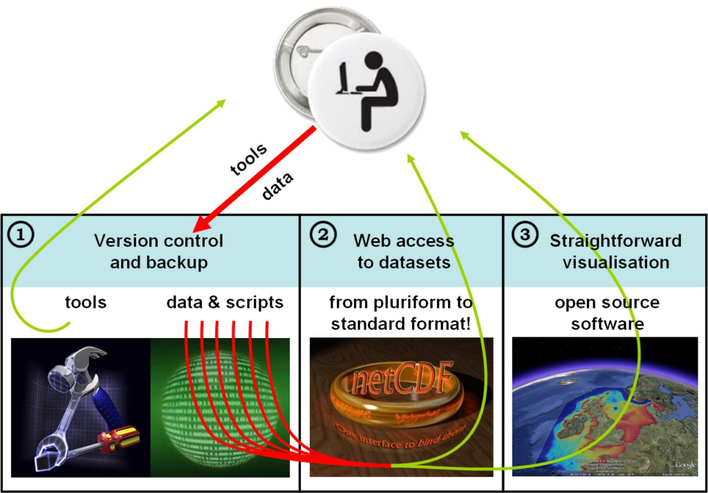
There are basically three kinds of web-services: for graphics, for data and for computer code. For graphics of data and model results OGC kml feeds (aka Google Earth feeds) are provided (3). For published data and model results an OPeNDAP server is provided (2) whereas for computer code (tools) , (unpublished) raw data and model input schematisations a Subversion repository is available (1). The workflow for users that only consume the data, models and tools is 3 > 2 > 1. This ‘getting started’ document is primarily meant for users that consume the data. In contrast, the workflow for the OpenEarth developers that provide all the data, models and tools is 1 > 2 > 3.
- 3. Google Earth feeds (OGC kml feeds) can be obtained without password restrictions from our kml server. Three types of kml feeds are provided:
- 2. NetCDF data (published data and model results) can be obtained without password restrictions from our OPeNDAP server:
http://opendap.deltares.nl. You can access an OPenDAP server directly with a web browser, or click on deeplinks in a Google Earth overview. NetCDF is an internationally recognized file format, an OGC standard and a NASA standard that can contain an unlimited amount of meta-information. Through OPeNDAP you can access a netCDF file from a OPeNDAP server as if it were on your local computer. This removes the need to download big files, you can simply request a small portion of a file. netCDF/OPeNDAP does the same thing for data what Google Earth does for all the worlds aerial pictures: just leave all data on a server, and download only what you need, when you need it.
- 1. Tools, (unpublished) raw data and model input schematisations can be provided for free albeit with a free username password. The reason for this is that when you want to access these, you are considered a developer, and we grant you write access. To prevent misuse, and to pay proper credit to your contributions, we require all developers to request a free username. This password-controlled repository is located at https://svn.oss.deltares.nl, it uses the same Subversion technique as sourceforge. Everyone can Join OpenEarth as an advanced user or a developer. The OpenEarth checkout includes the latest XBeach software and documentation, see and join XBeach.org to become a member of that community.