Planning and design
Important in the planning and design of the Melbourne port extension was the composition of the Supplementary Environmental Effects Statement (SEES). The composition of the SEES consists of different steps starting with creating an evaluating framework, determining environmental impact and risks in interaction and parallel with the project development process, and the listing of mitigation measures.
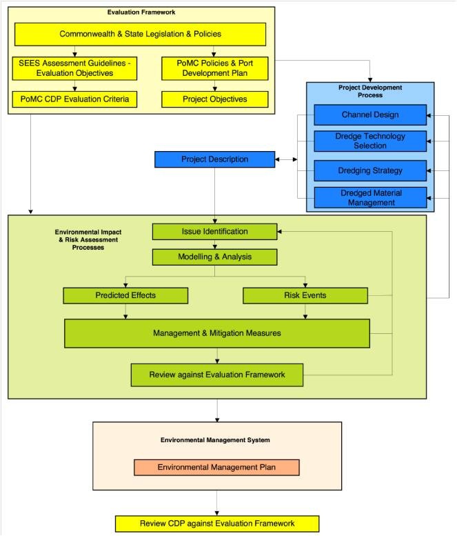
Evaluation framework
The Commonwealth and State of Victoria legislation and policy provided a foundation for the evaluation framework used to assess the environmental effects of the project.
In order to guide investigations, the SEES assessment guidelines set out evaluation objectives identifying the desired outcome of the project in terms of the relevant ecological, social and economic indicators.
The evaluation objectives have been adopted by PoMC with an additional objective focusing on the environmental footprint. These have been translated by PoMC into evaluation criteria to be used in the environmental impact and risk assessment process.
The identified criteria link back to relevant legislation and policy. Together the evaluation objectives and associated evaluation criteria provided a qualitative framework to evaluate the project and its effects.
Project development process
After the evaluation framework had been determined, the project development process started. This included the channel design, the dredging technology, the dredging strategy and the dredged material management (see blue area on the right in the flow chart). Once these were established on a preliminary bases, the Environmental Impact and Risk Assessment process started.
The system of the bay was better understood by identifying all relevant issues and investigating them by means of modelling and analysis. Based on these investigations, the environmental effects were predicted and risk assessments were carried out. Management and mitigation measures were included for the effects and risks that were not acceptable and could not be excluded. If nonetheless risks remained unacceptably high, a feedback mechanism was included by which the project design and dredging technology and strategy were adapted. Subsequently the whole cycle was repeated to check whether the new design and work method were acceptable risk-wise.
Finally the Environmental Management Plan (EMP) was drawn up in order to control the execution of the project on the basis of monitoring.
Environmental impact and risk assessment process
Issue identification
At the start of the Environmental Impact and Risk Assessment Process, the key issues relating to the ecological assets, social values and economic users of the bay were identified and investigated. This led to conceptual models about the system of the bay. These conceptual models show how the system works and how it may be affected by the construction works.
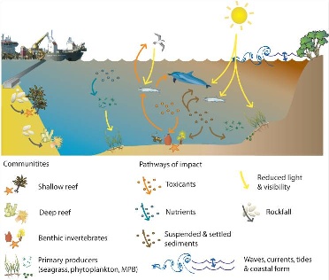
The key pathways conceptualized in the above figure include:
- Creation of a turbidity plume that may reduce the amount of light available to primary producers, such as sea grass and phytoplankton, and reduced visibility for some animals including fish and sea birds (yellow lines);
- Suspension and subsequent settlement of sediment that may clog biological structures and bury some biota on the seabed (brown lines);
- Mobilization of contaminants that may have direct toxic effects on biota or cumulative effects via bio-accumulation through the food chain (orange lines);
- Removal of rock at the Entrance that may result in some loose rock material falling and moving around the area, damaging shallow and deep reef biota (grey line);
- Mobilization of nutrients that may stimulate excessive phytoplankton growth (blue line), which at high levels of biomass can reduce the amount of light available to primary producers on the seabed (yellow line) and after dying out may lead to oxygen depletion;
- Changes in bathymetry that interact with tides, waves, currents and sediment transport, which in turn may influence coastal forms and coastal habitats.
These conceptual models were part of the input for the risk assessments.
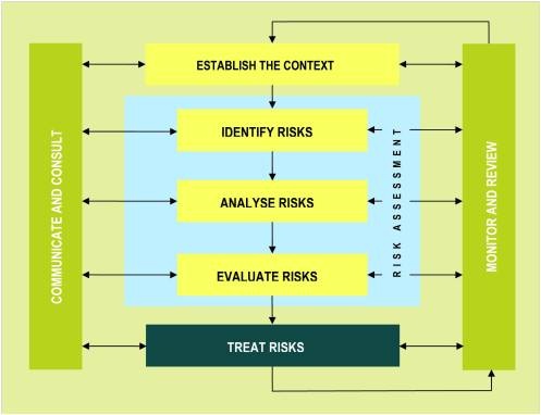
Risk Assessment
The development of the SEES document included an environmental impact and risk assessment. The risk assessments were conducted in a multi-disciplinary team, in an iterative process, consisting of the following steps (see also figure):
- Establish the context (project description and project development process)
- Identity the risks
- Analyse the risks
- Formulate a risk treatment strategy
- Implement the risk treatment strategy
- Review
Starting points for the environmental impact and risk assessment were the design (context), dredging technology, dredging strategy and dredged material management. In the impact assessments several investigation were carried out including the examination of historical data, modelling of data trends and literature review. The uncertainties associated with the natural variability were assessed as well.
Most ecological processes could be dealt with by assessing the likelihood of a potential impact to occur and the magnitude of any consequence, and where the associated risk was unacceptable, by implementation of physical works or environmental management measures. If the risks could not be mitigated to a satisfactory extent, the design and/or dredging technology and strategy would be adapted and the process would start over again, until the results complied with the evaluation framework.
During the risk assessments, the following assets were defined:
- Ramsar wetlands,
- marine parks,
- shallow reefs,
- little penguins,
- anchovy,
- dolphins,
- pied cormorants,
- sea grass,
- micro-algae,
- macro-algae,
- aquaculture fisheries, and
- bay users.
At first, also an increase of nutrients input into the bay, loss of heritage, economic loss and reduction of social values were seen as risks. After comprehensive investigations, however, these aspects were found to have a low probability of occurrence, to have negligible consequences, or to be easy to mitigate.
Extensive research was required to eliminate nutrients from the list with risks. The likely impacts and uncertainties associated with nutrient cycling have been modeled quantitatively with data from historical studies, field studies, baseline measurements and baseline bio-availability experiments. The results have been used as the basis of the formal assessment of the potential environmental impacts on the risks of dredging to algal blooms, nutrient cycling and denitrification. During a dredging trial, the impact of the released nutrients in the bay was analysed. This led to the conclusion that the impact of nutrient release in the bay could be identified as low risk.
Finally three major risks were identified that could not be avoided by adapting the work method or the design within economically acceptable bounds.
- Rocks falling on the deep reef habitat at the Entrance of Port Phillip Bay.
- The migration of contaminated material from the Yarra River into the Bay.
- An increase in turbidity as a result of dredging which could cause damage to the unique flora and fauna of Port Phillip Bay.
These threats were subject to additional investigations.
Mitigating measures
Below, the mitigation measures are described for the three major threats that were identified.
Mitigation measures for ‘1. Rocks falling on the deep reef habitat at the Entrance of Port Philip Bay’
The deep reef habitat (canyon) at the entrance of the bay consists of precious coral. If rocks fall on these coral reefs, they will be damaged. The main cause of this threat are leftover rocks (spill) which fall over the edge of the deep reef, driven by currents and wave action.
To mitigate this threat, a modified draghead (ripper draghead) was developed, designed to minimize the spill while cutting the rock. The ripper draghead was further optimized with the help of lab tests. Quarry tests were done to improve the cutting behaviour of the draghead. Dredging was done in a pre-determined pattern, thereby avoiding that cut pieces would be pushed towards the edges of the canyon.
After several passes of rock cutting with the ripper draghead, another cleaning draghead was dragged along the same route to remove the remaining loose rocks.
Mitigation measures for : ‘2. The migration of contaminated material from the Yarra River into the Bay’
Toxicity tests conducted in the Yarra River as part of the SEES determined that mud in these areas was contaminated. The most important threat of this situation was the possible release of the contaminated material during dredging, transport and deposition.
The mitigation for this threat consisted mainly of an adapted work method and a dedicated design of the disposal area. To make sure all contaminated silt was removed, the geometry and the draghead position were closely monitored. A bunded area was designed for the deposition of the contaminated material. It was placed in this area with a diffuser near the bottom to avoid mixing with the ambient water. Eventually, the contaminated material in the bunded area was covered with a clean sand layer.
Mitigation measures for : ‘3. Increase in turbidity as a result of dredging which could cause damage to the unique flora and fauna of Port Philip Bay‘
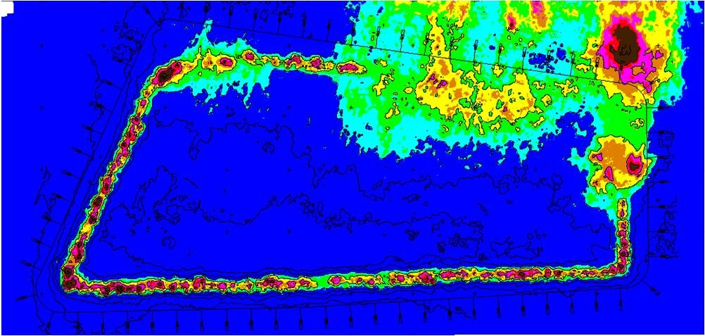
During dredging works, fine sediment may be released in the water, resulting in increased turbidity. The sediment particles in the water column hamper light penetration, which may lead to decreased primary production by photosynthetic organisms, particularly benthic plants, such as seagrass. This reduction in productivity and biomass may indirectly affect other biological components in the Bay system, e.g. via reduced food availability to grazers and less habitat for juvenile fish.
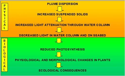
The physical relation between turbidity and light attenuation is poorly known. The biological effects of light attenuation are even more complex and difficult to determine. In order to obtain more insight into the biological effects of turbidity, extensive research has been conducted. This research led to realistic and scientifically based turbidity limits.
The research involved the following steps:
- Investigate impact pathway – assess plume consequence
- Determine distribution & condition of plant species
- Model plume extent, concentration and duration
- Predict light climate – natural & during dredging
- Assess biological response of plant species to reduced light conditions
- Estimate impact
- Assess impact against project acceptability criteria
- Define mitigation & management options
- Draft monitoring program
The first five points were investigated using literature studies, field investigations and modelling and are described in more detail below.
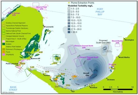
The distribution and conditions of plant species and the plume extent, the concentration and duration were determined by means of an impact study. First the turbidity plume is modelled, including the concentration and longevity of the plume. The turbidity dispersion model was validated with a dredging trial conducted during the development of the SEES. Within the boundaries of the modelled plume, the amount and type of plant species were determined. This led to estimated light reduction in the vicinity of the plants during the construction works.
The biological response to the reduced light conditions is determined from literature and with the help of shading experiments. Two types of shading experiments were carried out on Heterozostera and Amphibolis (seagrass) and Ecklonia (kelp) in Port Philip Bay:
- Shade for an intermediate period of time (e.g. 2 months): the plant is under stress, but can recover.
- Shade until mortality, or at least three months.
From these investigations, the biological impact is estimated. This includes the short-term bay-wide effects and the long-term localized effects on ecological processes. Yet, a lot of uncertainties remain, such as the long-term trends in distribution and abundance of plants, the variation in plume exposure and the response to seasons and other environmental variables. In winter, for instance, there is significantly less light intrusion in the water column than is summer.
The results of this modelling and analysis were used together with the risk assessment process to evaluate the potential environmental effects. The effects were considered in relation to the adopted evaluation objectives and associated evaluation criteria. The process was iterative and the project plan was changed in response to adverse findings.
Environmental limits were set for the management of the plume, to ensure that short-term adverse impacts were minimized and there were no long-term adverse impacts on the key functions of the Bay. The environmental limits were based on the known impacts, based on modelling and field investigations, of increased suspended sediment concentrations and known concentrations that marine organisms can tolerate without severe or lasting impacts.
A significant concern was the impact of elevated turbidity on seagrass health and survival. Turbidity thresholds were established that allow for minimum light requirements to sustain healthy seagrass meadows in the most vulnerable areas of Port Phillip Bay. An evidence based numerical criterion, (supported by ecological judgement) was established: the minimum light requirement for seagrass maintenance was expressed by 15% of the surface irradiance, at 3 m depth during 50% of the time. Based on this criterion, a statistical analysis of the results of the turbidity dispersion model determined the sediment concentration limits. As biological turbidity criteria are usually expressed in the physical measurable quantity of total suspended solids (TSS in mg/l), but these have been converted to the site-specific optically-measurable quantity of turbidity in NTU, as these are directly measurable. The conversion rate has been determined with help of local experiments.
Conclusive SEES investigations
To conclude, the SEES investigations have:
- Identified relevant threatened species and ecological communities, migratory species and Ramsar wetlands under Commonwealth and state legislation and have considered these as ecological assets in the environmental impact and risk assessment process.
- Used the results of the environmental impact and risk assessment to provide feedback to the project design, so as to minimise impacts on marine and terrestrial threatened species and ecological communities, migratory species and Ramsar wetlands. This includes modifications to the dredging strategy in response to potential risks to the protected fish species in the Yarra River and seasonality of other species.
- Considered the conservation of biodiversity in the project development process, in the environmental impact and risk assessment and in the development of the EMP to address residual risk that could not be eliminated otherwise.
Boskalis assisted PoMC with the Supplementary Environmental Effects Statement (SEES), clarifying and justifying equipment selection, participating in the rock fall assessment, fauna mapping in the Entrance and sampling of contaminated soil. Boskalis also cooperated with PoMC in developing the Environmental Management Plan (EMP). Overall, Boskalis’ participation in the SEES was crucial to optimize work methods in order to meet strict environmental controls and intense government scrutiny.