Operation and Maintenance
An extensive monitoring program of four years was set up to measure the development of the sandy sections and vegetation to be able to gain the required knowledge for further advancement of these types of solutions.
The monitoring program focusses on three areas:
- Meteorology and hydrodynamics, i.e. wave and current patterns as forcing on the section
- Morphodynamics as a result of soil settlement, wave and current driven erosion/sedimentation and the role of vegetation in said processes
- Vegetation development for the purpose of flood safety and ecological value and the influence of different vegetation maintenance strategies on the vegetation development
Meteorology and hydrodynamics
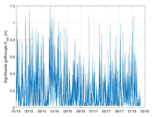
The wind speed and direction, water levels, wave and flow conditions were measured. In the monitoring period from 2014 to 2018 the maximum measured wind speed was 23 m/s and waves up to 1,27 m high were measured (Rijkswaterstaat & EcoShape, 2018a).
Morphological development
The shape of the sandy section is monitored in terms of longshore shape and alignment of the section. Also, the cross-shore profile is monitored along with calculations of the volume of the section to see if there are changes. Over the course of the monitoring program the volume of sand in the design has been virtually stable, even after several severe storm events. This proves that a stable sandy foreshore solution is viable in a lake environment.
Some notable changes were observed in the shape of the pilot. The cross-shore profile developed into a steeper and higher part around the waterline that aligns and changes with the changing incoming wave angle. Under water (i.e. -1m) a relatively flat plateau was formed, which does not react to changing wave climates.
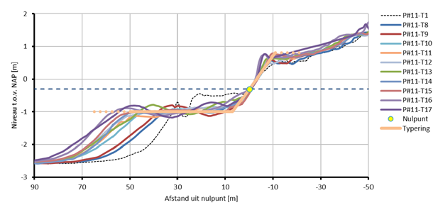
The development of this plateau was not expected, and it was studied further by excavating a part of the plateau and monitoring the subsequent reshaping (Arcadis, 2018). This led to the conclusion that the plateau is mainly (re-)formed by longshore processes. Therefore, it does not significantly add to the flood defense function of the total cross-section. The insights from this additional monitoring campaign have been used to update and validate a numerical model for beach design (Xbeach).
Vegetation development
The vegetation growth is monitored with the aim to find the most efficient way of growing vegetation on a sandy foreshore and have a functioning system as soon as possible. This is tested by applying different combinations of vegetation and substrate/subsoil. The pilot was divided in several sections:
- with and without sowed seeds
- with and without protective measures against grazing animals
- with and without mixing of Holocene soil in the top layer
- with reed fixing matts around the water line
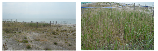
An important conclusion is that the mixing of Holocene soil in the top layer has a large positive effect on the initiation of vegetation growth. By comparing the plots with and without nets to prevent grazing, the negative effect of grazing becomes inevitable. The reed that was planted around the water line in reed fixing matts proved to be impossible to sprout under the prevailing wave conditions in the area. Wave heights >0.2m are sufficient to drown the seeds and prevent growth.