How to Use
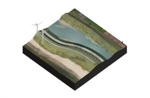
A double-levee system enables zonation of flood risk. The flood risk in the buffer zone can be higher than normal standards. The advantage is that the primary dike does not have to be raised when sea level rises and will save costs. In fact, limited overflow can be permitted. When allowing water and higher groundwater levels in the area between the dikes this can also reduce land subsidence processes. To enable overflow of the crest of the dike, the landward side of the primary dike might have to be strengthened. Depending on the frequency of overflowing, the area between the dikes is subject to occasional flooding which puts limitations on land use. By choosing low-lying, coastal areas with extensive land use (nature areas), the adverse effects on land use practices are brought to a minimum.
Boundary conditions
Site suitability
Areas that are interesting for application of a buffer zone are mostly low-lying areas where a secondary dike is already present. In areas where land has been reclaimed in the past, former sea dikes are often present inland. Some of these areas are dominated by salt water seepage which makes the land less valuable for agriculture or housing. These areas are very suitable for the application of a coastal buffer zone.
Dikes
Some adjustments need to be made to ensure dike stability:
- The primary dike should be able to overflow, therefore the inner slope of the dike should be checked for overflow resistance and if necessary should be strengthened and hardened to prevent erosion during overflow.
- The secondary dike should be strong enough to withstand water flowing over the primary dike and should be adjusted if necessary.
Safety standards
The double-levee system should be suited for regular flooding. Where flood risk standard for inhabited areas are set to 1/4000 year or even 1/10.000 year, a standard of 1/100 or even 1/50 is allowable in the buffer zone. This will considerably reduce costs on dike maintenance and strengthening.
Design & Construction
Preferably a coastal buffer zone is applied where two parallel dikes (one shore side, one inland dike) are already present. This will save the expense of constructing a second dike. Based on the ComCoast pilot at Ellewoutsdijk a concrete example of a coastal buffer zone is summed up below:
- The crest of the primary dike is strengthened with asphalt.
- Flood risk 1/50 is allowed. Once every 50 years on average, a few decimeters of water will collect between the two dikes, and once every 100 to 250 years, 1 m or 2 m of water will collect. This will not pose a threat to the safety of the land behind the secondary dike. An even lower flood risk could be allowed to benefit certain goals as nature development and at the same time still guarantee a sufficient safety level.
- The landward side of the old dike is strengthened with open asphalt covered with soil allowing grass to grow on.
- The seaward side of the new dike is strengthened with a layer of open asphalt. This layer is covered with soil allowing grass to grow on. These areas are also suitable pastures for live stock to graze upon.
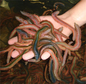
Ragworms 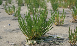
Common glasswort
Land use practices
Areas that are applied as coastal buffer zones are usually low-lying areas along the coast, subject to salt water seepage unsuitable for cultivation of crops and livestock. Most of these areas are therefore nature area. Because of the variation in salinity of fresh, brackish to saline, vegetation is diverse. The brackish water area with shallow pools provides a valuable foraging, roosting and nesting area for birds. Especially with high water birds will move here to find their food. This coastal nature enclosed by dikes also provide opportunities for recreation like walking and cycling along the dikes along the area. It is also a good place for bird watchers for many different types of birds to be spotted.
Aquaculture and saline crops
The (near) availability of salt water and relatively controlled conditions that make a coastal buffer zone have potential for aquaculture and saline crops. The table below describes several forms of saline land use with a potentially high market value, based on De Mesel et al. (2013) and related studies.
| Type | Species | Method | Yield | Reference |
|---|---|---|---|---|
| Shellfish | Blue mussel – Mytilus edulus | Mussel growth on poles (“Bouchot”) in the intertidal zone | 41920 €/ha/year | www.fao.org |
| Pacific Oyster – Crassostrea gigas | Oyster growth on “tables” in the intertidal zone | 25000 €/ha/year | www.fao.org | |
| European flat Oyster – Ostrea edulis | Oyster growth on “tables” in the intertidal zone | 20900 €/ha/year | (Van der Hiele et al., 2008) and related references | |
| Worms | Ragworms – Nereis virens | Extensive digging for rag worms at low tide | ? | ? |
| Sea weeds | Tough Laver – Porphyra umbilicalis | Marcoalgae attached to floating devices | 651 | (Lobban &Wyne, 1981) |
| Hudson – Gracilaria verrucosa | Marcoalgae attached to floating devices | 435 | (Xin, 1989) | |
| Saline vegetables | Common glasswort – Salicornia europaea | Harvest from wild growth on salt marshes | 84000 €/ha/year | (Van de Voort et al., 2005) and related references |
| Sea aster – Aster tripolium | Harvest from wild growth on salt marshes | 35000 €/ha/year | (Goosen, 1999) |