How to Use
Shallow foreshores or floodplains take space, so they can only be applied where enough space is available. In the case of lakes this is usually not a problem, but in rivers this point requires special attention. Depriving a river from its storage space has implications for the height and propagation speed of flood waves. Since flood storage in a river is determined by the width at the water surface, this means that the foreshore level should preferably stay below the design water level. On the other hand, the level should be high enough to be effective in attenuating waves under design conditions.

Note that the effect of storage on flood wave propagation only counts at some distance from the mouth. In medium-size rivers, like the Rhine, the fetch for local wave generation is not very large there, but in larger rivers like the Mississippi or the Yangtze locally generated waves can be higher and their attenuation by shallow foreshores can be an issue, also further upstream.
Freshwater wetland vegetation generally requires suitable hydrodynamic conditions and not to long submergence times. Rivers wetlands can be threatened by unnatural flow conditions, caused for instance by upstream dams, locks and sluices. In lakes wetland development is often hindered by fixed or unnatural water levels, such as a highstand during summer for water storage, and a lowstand during winter to reduce flood risk. Even if the lake level is constant or low, however, inundation of low-lying areas can occur due to storm-induced water level set-up. In Lake IJssel (IJsselmeer, the Netherlands), for instance, wind-induced downwind set-up during extreme events can amount to 1 m above the mean lake level (RWS-RIZA, 2007)
Cross-shore profile
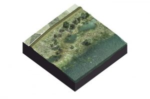
The profile of a foreshore levee is determined by inundation depth, inundation frequency, mean water depth (lower parts) and groundwater level (higher parts). In the lacustrine case, this profile often consists of a soil retaining ridge of relatively coarse sand, if necessary with a hard revetment at the outer side around the mean water level. It also contains a low-lying area supporting a wetland habitat, an upward sloping part to attenuate the incoming waves, a sandy buffer in front of the dike and a shallow ditch in front of the dike in order to control the groundwater level. Reeds can grow in shallow water up to 0.5 m depth with respect to the mean water level. Wetland vegetation will be limited to a zone up to approximately 0.5 m above mean water level. At higher levels grass and shrubs will tend to dominate. Note that such foreshores may also occur naturally. One example is the wetlands on the Frisian coast of Lake IJssel, which evolved from the salt marsh present there before the lake was closed off from the sea in 1932.

Material
As far as the material used is concerned, much will depend on what is available in the vicinity. In any case, the vegetation-supporting part must contain enough fines and nutrients to be sufficiently fertile. Wave attenuation is often less of an issue in the narrower parts of a river, i.e. upstream of the mouth area. There the main function of a forelshore in front of the dike is to increase the stability of the outer slope and to prevent seepage-related phenomena such as piping, heaving and bursting. The latter is usually achieved by digging in a clay layer and covering it with the original topsoil, to increase the seepage length and thus to reduce the probability of piping. This method also stimulates the re-establishment of vegetation. In the case of lacustrine foreshores, the sand ridge at the offshore end must either provide for a sufficient buffer to accommodate erosion during an extreme event, or be adequately protected against erosion. An important material property is the soil permeability after placement. On the one hand, permeability should be small enough to prevent piping and drying out of the wetland part, on the other it should allow for sufficient groundwater supply to the vegetation.
Vegetation
If the vegetation is an essential part of the flood defence system because it has to provide for a significant part of the wave attenuation vegetation development needs to be considered. Several options are possible to account for this, such as a more robust design of the soil part of the foreshore or possible planting of more developed tree or shrub vegetation. However, if conditions are suitable for vegetation development and there is sufficient seed availability natural vegetation establishment with considerable biomass can be extremely rapid. Vegetation may need some form of maintenance, such as grazing or mowing. In the very least, it needs to be adequately monitored.

Costs
Construction costs of foreshores are largely determined by the cost of the required volume of sediment. Maintenance costs involve maintenance of the offshore sand ridge and the vegetation cover. After an extreme event it may be necessary to restore parts of the profile. Construction costs will be comparable to or even less than those of traditional dike strengthening. Monitoring and assessment may involve extra costs as compared to a traditional dike (Table 1, see Haskoning 2011).
Cost estimates for two foreshore project designs described further below (after Haskoning, 2011).
| case | variant | construction in million €/m | Annual maintenance in €/m | uncertainty of pricing |
|---|---|---|---|---|
| Oeverdijk Markermeer | eco-variant (reed marsh) | 2.25-3.55 cheaper | 2.5-1 more expensive | 40% |
| basic variant (equil. profile) | 2.75 cheaper | 7 more expensive | 40% | |
| Fort Steurgat (Noordwaard) | clay-grass cover + willow forest | 1.55 cheaper | 2 more expensive | 25% |
From a life-cycle costing perspective, construction of a levee with a shallow foreshore is likely to be cheaper than a traditional design, as cost savings on construction are relatively high compared to the extra costs for maintenance. Especially if the foreshore designs are able to trap sufficient sediment to keep up with gradually changing hydrodynamic conditions (lake level, river flood levels and sea level rise) future costs for maintenance and levee upgrading may be considerably less.
Ecosystem services
The foreshore ecosystem can provide a variety of ecosystem services:
- regulating services, such as wave attenuation, erosion prevention, sediment trapping, soil formation, nutrient cycling, greenhouse gas sequestration, water purification;
- provisioning services, such as groundwater storage, food production for herbivores, resting/foraging/breeding place for migratory and residential birds, biomass production, corridor between separated existing ecosystems, nursery for fish, shellfish and crustaceans;
- supporting services, such as the availability of freshwater wetland habitat, room for a variety of recreation functions;
- cultural services, such as the aesthetic value of a ‘natural’ landscape.
Multi-functional use
Foreshores may be used for a variety of other functions, such as recreation (beaches, small marinas) where there is room for it, eco-tourism, extensive herbivore grazing and meat production, biomass production (in relation to vegetation maintenance), etc. Some existing foreshores have been built up to a level well above flood level and are being used as industrial zones. In that case, there are no nature functions, but the dike stabilisation and piping reduction effects remain.