Practical Applications
What's on This Page
Fluvial forelands
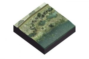
Wave attenuating willow forest – Noordwaard – Netherlands
In order to make room for the “Nieuwe Merwede”, a river branch in the downstream Rhine-Meuse complex, an area of the polder Noordwaard (about 2000 ha), will be used for flood conveyance. To that end, part of the existing dike, designed for water levels with a probability of exceedance of 1/2000 per year, will be lowered to a crest level which is exceeded by floods with a p.o.e. of 1/100 per year.
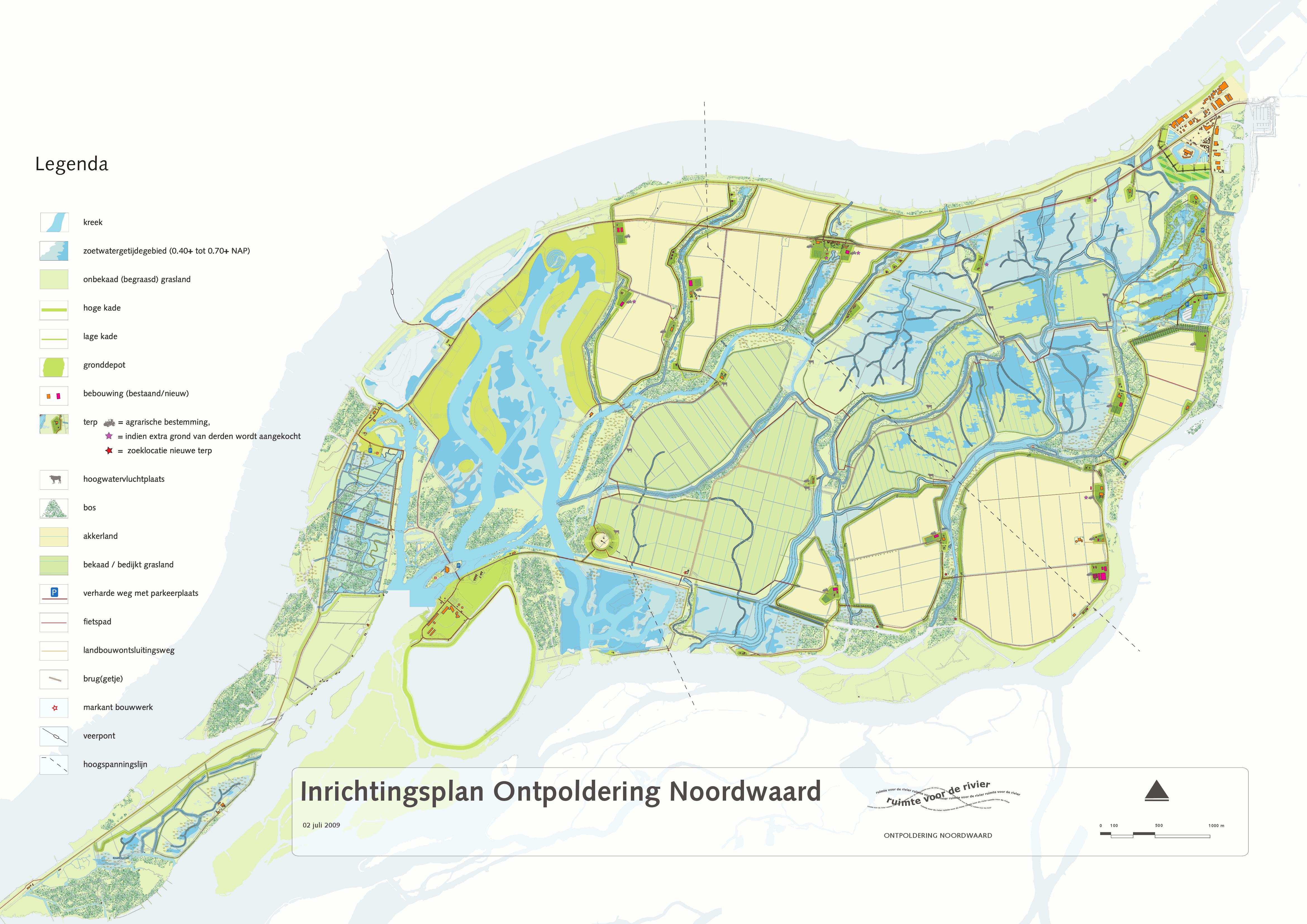
In the northeast corner of the area Fort Steurgat is located, an old fortress that has been turned into apartment buildings. The dike around the fortress now becomes part of the primary flood defence system, which in present practice would mean that it has to be raised and strengthened to resist a flood with a p.o.e. of 1/2000 per year while bordering a large open water area (the inundated Noordwaard) with wave heights up to 1 m. A first ‘traditional’ dike design around Fort Steurgat resulted in a dike height of NAP + 5.5 m (NAP = datum and approximately the ground level here), with an armour layer of concrete blocks. This led to opposition among the local population and an alternative was sought with a visually acceptable wave-attenuating element in front of the existing dike.
As an alternative, a building- with-nature design was made that is cost-effective and provides not only safety, but also sustainability and nature value: a wave-attenuating willow forest in front of the dike. In the past, willow forests were ubiquitous in the Dutch river floodplains. They were used for the production of brushwood, among others for application in hydraulic engineering projects.

The final design includes a continuous willow tree plantation in front of the dike, which is expected to yield 80% reduction of the incoming design wave height. Although the willows are planted on a low embankment, it is mainly the vegetation that does the job here. The reduced discharges due to wave overtopping allow to dike crest to be 70 cm lower than in the traditional design. Moreover, a clay-clad dike is able to resist the remaining wave attack, so there is no need for a concrete block revetment. The overall ‘footprint’ of this alternative design is wider, which is not a problem in this case.

Having a living element as part of a flood defence system is outside of the present expertise of dike engineers and inspectors. This means not only that expert input from biologists is needed, but also that new methods of assessing the flood defence system have to be developed. Moreover, this living element involves a certain degree of uncertainty whether the forest will be in good shape at the moment it is needed. In order to reduce the system’s sensitivity to pests, diseases, ice winters, forest fires, etcetera, special measures have been taken, such as the use of a mix of willow species, and zonation of the forest with fire corridors in between. An alternate mowing an cutting scheme assure the continuous presence of zone with a dense forest of 2-year branches.
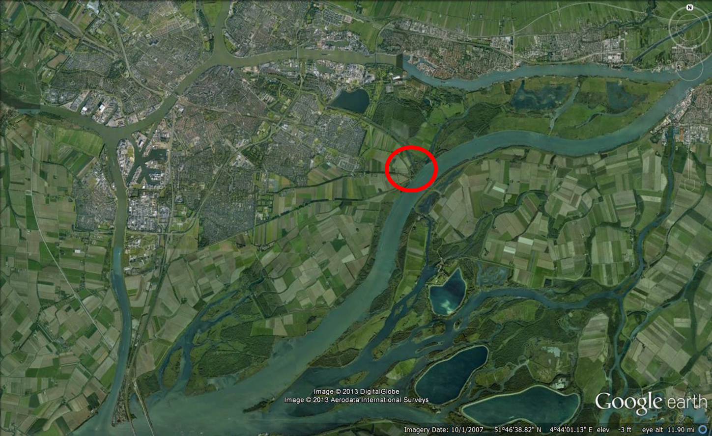
Kop van ‘t Land – Island of Dordrecht
Near the mouth of a river, especially in areas where the influence of tides is felt, the width increases significantly and locally generated waves become a point of attention. In that case, their effects can no longer be ‘hidden’ in a safety margin for the crest height, but have to be taken explicitly into account in the design of the flood defence system.
One location where this is the case is the Kop van ‘t Land, the easternmost tip of the embanked part of the Island of Dordrecht. Here the Nieuwe Merwede, one of the main branches of the Rhine-Meuse complex, is already wide, with the Noordwaard area at the other side. This means that during high floods, when the Noordwaard is inundated, there is a considerable fetch for winds from south-westerly and south-easterly directions.
The dike at Kop van ‘t Land has a key function in protecting the urbanised area of the Island of Dordrecht from flooding. From a risk management perspective, it is therefore wise to make it very strong and safe. This will indeed be done in a forthcoming strengthening project. So far, however, possibilities to reduce wave attack have not been considered. There is ample space for vegetation-covered foreshores at either side, and also across the river vegetation can help reducing the wave exposure. In a forthcoming pilot project, the possibilities to better use vegetation and shallowness to reduce wave attack on this dike will be further investigated.
Wieldrechtse Sea Dike – Island of Dordrecht
At the Island of Dordrecht (a most interesting place from a flood risk management point of view), there is also the Wieldrechtse Sea Dike, which now serves as a secondary flood defence at the south side of the urbanised part of the island. South of it is a zone of agricultural land, protected by a primary flood defence which presently satisfies the safety standards. The west part of the area includes some vital infrastructure, such as the north-south motorway A16, the railway between Rotterdam and Brussels and the high-speed railway Amsterdam-Rotterdam-Brussels-Paris.

As the urbanised area north of the Wieldrechtse Sea Dike is located in a small dike ring that will rapidly flood if anywhere the flood protection system fails, timely evacuation will be difficult. Hence the individual risk is above the norm of 10-5 per year that will be part of the new flood safety norm system to be introduced in the Netherlands. Therefore, the flood protection of this area will have to be enhanced. As there are no plans to urbanise the southern part of the island, the present safety norm can be maintained there. This has led to the idea not to raise and strengthen the existing primary flood defence, but to use the southern part of the island as a shield against flooding of the urbanised area. South of the eastern part of the Wieldrechtse Sea Dike a park with wave-attenuating vegetation is planned (the light green area in the figure above), which in combination with the existing dike must provide for the required safety. The present primary dike will stay in place. This spatially extended option of a flood defence system (as opposed to the usual line approach), which is probably cheaper than strengthening the existing primary defence, will be further explored in a forthcoming pilot study.
Other examples of floodplain restoration and engineering
In various river basins around the world large areas of floodplain are being reconnected to the river, for instance by removing or laying back levees. Thus flood levels are brought down, the water quality and spatial and environmental quality are enhanced and new opportunities are created for economic activities such as recreation. Examples are: the Make Room for the River program for the Dutch Rhine in the Netherlands, various floodplain restoration schemes along the Danube, and floodplain projects in the Mississippi basin.
Floodplains along tidal rivers are important to accommodate and attenuate tides and storm surges penetrating into the river. Encroachment on these areas in the past has led to an increase of flood levels, tidal range and, in combination with channel deepening for navigation, to a net import of fine sediment and very high levels of turbidity. Examples are the Scheldt in Belgium (increased flood levels and tidal range; e.g. Dam et al., 2013), and the Loire in France and the Ems in Germany (increased tidal range and turbidity; Winterwerp and Wang, 2013; Winterwerp, 2013). Examples of floodplain reconnection to a tidal river can be found along the Belgian Scheldt, for instance (Temmerman et al., 2013).
Lacustrine foreshores
Oeverdijk – Lake Marken
Lake Marken (Markermeer) used to be part of the former Zuiderzee, later Lake IJssel, and was separated in 1976 from Lake IJssel by the Houtrib Dike. The original intention to reclaim the land was given up and the area remained a shallow lake. In the 2006 assessment of the Dutch flood defence system the dikes at the west side of this lake were found insufficiently stable and susceptible to piping. Raising them, however, might be problematic, as they are resting on a thick layer of peat. This has led to two responses: a study on how much weight the peat subsoil actually can carry and the development of an alternative to dike strengthening, the so-called Oeverdijk. It is basically series of shallow wave-attenuating, piping-preventing and stabilising foreshores at the lakeside of the existing dike.

The design of the foreshore varies alongshore, depending on the local bathymetry and possibilities for ecological optimization. At many locations, the designed foreshore is higher than the design water level, which would render the existing dike redundant. Yet, this is maintained for security and because removing it will be more expensive than leaving it in place.
One aspect that needs to be tested is the chance that the foreshore is eroded away or that its top breaches during an extreme storm. In order to have a worst-case estimate, a dynamic dune erosion model has been applied to the foreshore profile as if it were bare loose sand. Conclusion: the profile tested provides for a sufficient buffer for the top part not to be eroded or breached. Clearly, this a test is case-specific and has to be repeated for every new profile.
Houtrib Dike – Netherlands
Although the Houtrib Dike separates two bodies of water, it is part of the primary flood defence system. In the 2006 assessment the dike’s revetments (among other elements) at the side of Lake Marken were found to be insufficiently stable. A wave-attenuating (and ice-resistant) foreshore would be an obvious option here. As strengthening of this dike is considered less urgent and is actually subject to debate, the authorities responsible decided to first carry out a pilot project with a shallow foreshore along part of the dike.

Along a short stretch of this dike Rijkswaterstaat and EcoShape are about to carry out a combination of three pilot experiments, with foreshores of different width (i.e. the distance between the intersections of the foreshore profile with the existing dike profile and the lake water level). The foreshores mainly consist of sand, whence their capacity to cope with the design wave attack has been tested with a standard dune erosion model (XBeach). The sand bodies are to be planted with vegetation to attenuate incoming waves and to prevent wind erosion. Moreover, the sand body is supposed to keep floating ice away from the dike and the road.

Sand engines – IJsselmeer (NL)
At the time Lake IJssel was formed by the construction of a 30 km dam that closed off the sea arm Zuiderzee, the Frisian coast was bordered by extensive saltmarshes. As the water of the lake gradually turned fresh, the saltmarsh turned into freshwater wetland. In the meantime, this has become a most valuable ecosystem supporting rare plant species and large numbers of resident and migratory birds.

Although this foreshore was not man-made, but only influenced by man-made works (the dam that closed off the sea arm), it functions as a wave-attenuating element in the flood defence system. Now that the vegetation has reached its climax stage and is gradually losing its vitality, and the shoreline is slowly eroding, a pilot experiment with an offshore nourishment is being run, with the intention to gradually bring sediment onshore, stop erosion and create space for new pioneer vegetation without destroying the existing one. For more details and figures, see Sand Engine Workumerwaard.
Lessons Learned
- Depending on the situation, dike raising and strengthening can be avoided by creating a shallow wave-attenuating foreshore.
- Such foreshores also create room for multi-functional use, thus to enhance the system’s benefits.
- There is no generally applicable design, the solution to be chosen depends on the local physical, ecological and societal situation.
- Until this has become proven technology, many decision makers are reluctant to adopt this type of solution, because of the perceived risks involved (project delay, uncertainty of the nature component). For the time being, implementation of these concepts in practice depends on ‘champions’ at high political and administrative levels. They can help to get a number of pilot projects off the ground in order to show that the concept works in practice and can be cost-effective.
- Cost-benefit analyses should take a long-term perspective, with a time horizon exceeding the lifetime of the present project. In that case, the adaptation capacity of shallow foreshores becomes part of the equation.
- Discounting, as usual in cost-benefit analyses, does not apply to nature components in hydraulic engineering projects, as these cannot be purchased at an arbitrary point in time, but need time to develop.