How to Use
The focus of this section is on the “technical” use of the Interactive Design Tool. For more information on the setting in which these types of tools can best be used we refer to the Interactive group modelling – MapTable tool description.
Starting point of the Interactive Design Tool is that it is easy to use, also by non-experts. Therefore, the user interface strives to facilitate intuitive use, by limiting the number of buttons, keeping the number of required user actions to a minimum and checking for erroneous input. Results are visualized in a Google Earth window, which most users are acquainted with. In its present (2012) form the tool gives a first estimate of the impact of coastal interventions. Results should be interpreted qualitatively rather than quantitatively. Although starting a simulation is relatively fast and easy, workshops in cooperation with Atelier Kustkwaliteit made clear that proper interpretation of the results requires knowledge of coastal processes, underlying model assumptions and the relations linking indicators to coastline development. Therefore, when using the tool in practice (in stakeholder workshops), it is strongly recommended to appoint a moderator with such background knowledge. This moderator can put the results into perspective and explain the possibilities and limitations of the tool.
Requirements
The Interactive Design Tool for the Holland Coast is available in two versions:
- As an online application accessible through the OpenEarth Viewer.
This version is meant for end-users, i.e. users who want to use the application as is and are not interested in modifying the underlying code and models. The only requirements for using this application are an internet connection and installation of the Google Earth plug-in (indicated automatically when needed).
Note: This application is known to encounter problems . - In the OpenEarthTools repository (Matlab code & web code).
This folder contains all the underlying codes and is meant for developers rather than end-users. Help for installing the tool can be found at the OpenEarth website. Furthermore, users need to have Matlab and Unibest-CL+ licenses.
Functionality
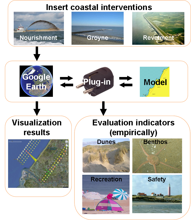
Setting up a scenario for the Interactive Design Tool involves the following steps, following the flowchart shown above:
1. Browse to viewer.openearth.nl, open the project Building with Nature, select the case Holland Coast and navigate to the tool Interactive Design Tool Holland Coast. The following window should pop-up:
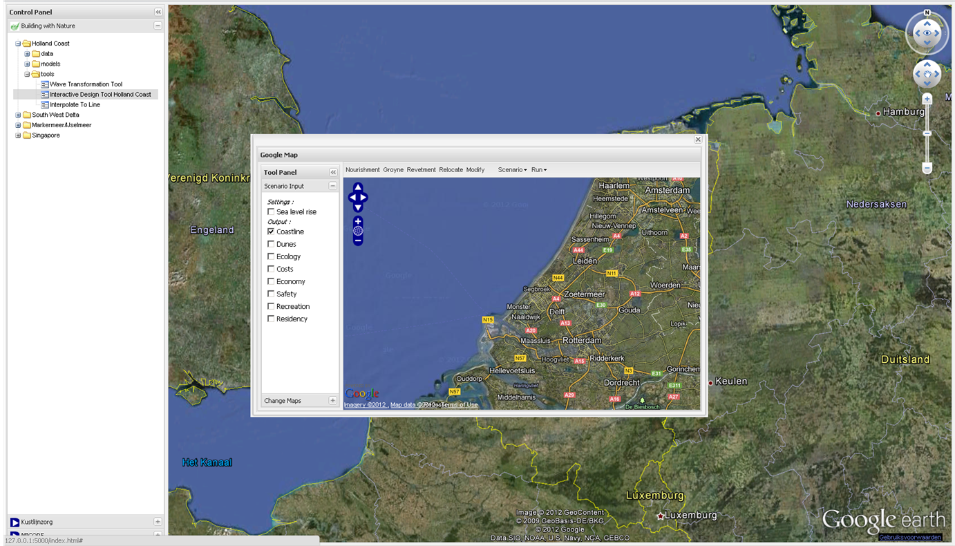
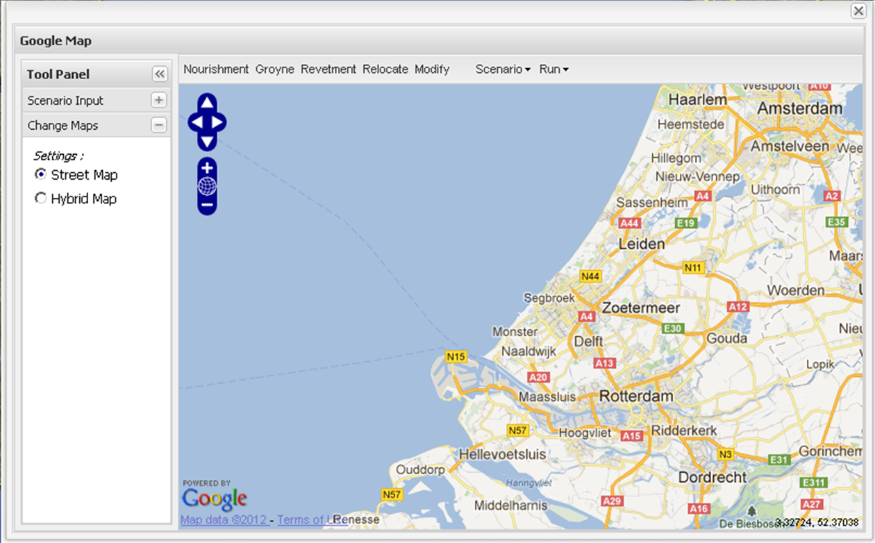
2. The Tool panel consists of two menus, i.e. ‘Scenario Input’ and ‘Change Map’. In the ‘Scenario Input’ menu, the user can select whether sea-level rise needs to be taken into account and which indicators should be processed. In the ‘Change Maps’ menu, the background map can be chosen, as is shown in the following screenshot:
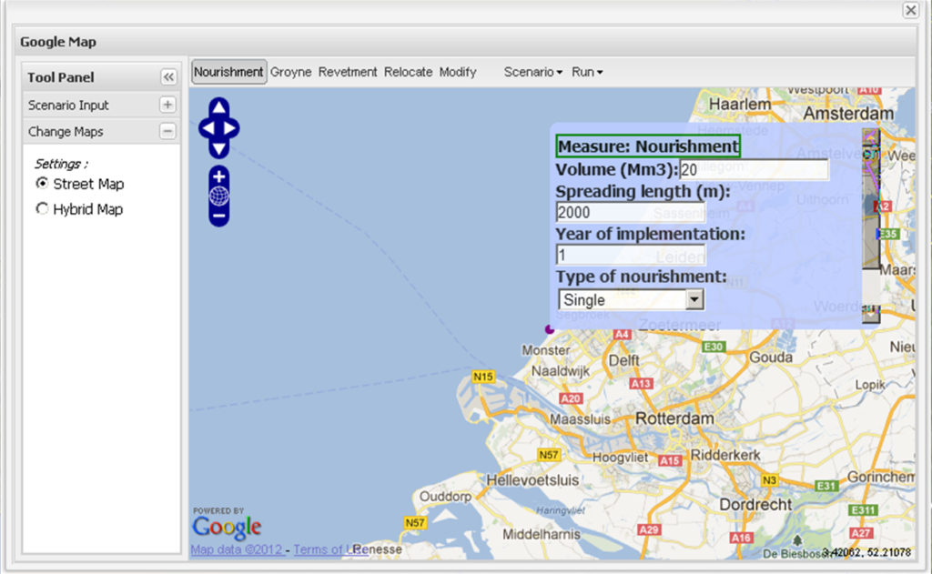
3. The user can add measures (nourishments, groynes or revetments) by selecting them from the toolbar and clicking the location where the measure should be implemented. Automatically, a window pops up in which the user can fill out specifications for the selected measure (see screenshot for adding a nourishment). Measures can be moved by selecting the button ‘Relocate’, selecting the object to be relocated and dragging it to its new position. With the ‘Modify’ button, the user can adjust the specification of the measures.
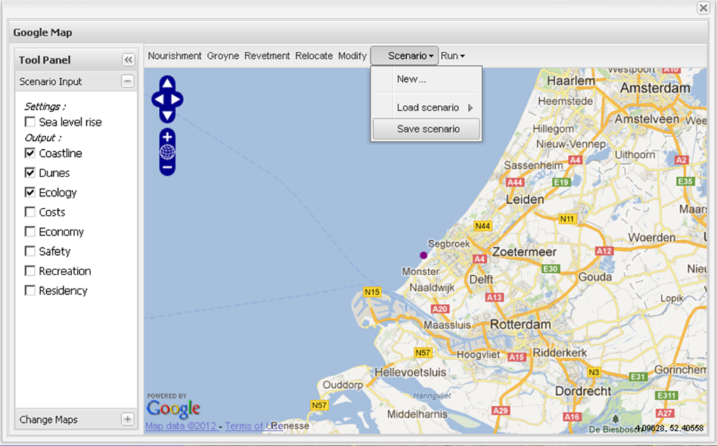
4. In the ‘Scenario’ menu, the user can start a new scenario (all existing measures are deleted and a default empty scenario is loaded), load a previously saved scenario, or save the scenario he/she has been working on (see screenshot).
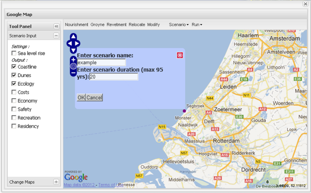
5. Once the user is satisfied with the scenario, he/she can select ‘Run scenario entirely’ from the ‘Run’ menu. This will trigger a window (see screenshot) in which the name and duration of the scenario can be selected. Upon pressing ‘OK’ the simulation will start.
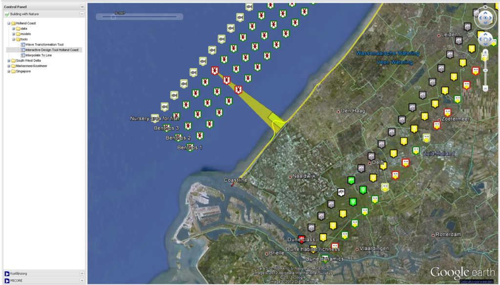
6. The results will be shown in the Google Earth Panel of the OpenEarth Viewer (see screenshot). The yellow triangle indicates the location of the nourishment, the yellow line the coastline position, and the red and green bars an exaggeration of erosion and deposition along the coast relative to the initial coastline. The icons indicate the states of the indicators. In this example, dunes (dune class, habitat richness, dynamics) and ecology (three types of benthos and nursery area for fish). Red icons indicate a worsening state, green colors an improving state and yellow/grey colors approximately equal state relative to the initial state.
Working principles
The Interactive Design Tool for the Holland Coast consists of the following modules:
- User interface. The user interface of the tool consists of an OpenLayers map, which is plugged into the OpenEarth Viewer. On the OpenLayers map users can draw measures (i.e. nourishment, groynes and revetments) and adjust their specifications to develop a scenario. Results are visualized in the Google Earth panel of the OpenEarth Viewer.
- Plug-in module. The plug-in module consists of a set of functions used for the pre- and post-processing of the (numerical) model. For this tool the plug-in consists of Matlab code, but this can be any type of programming language. In the pre-processing the model simulations are prepared based on the user input, whereas in the post-processing the model results are linked to indicators and written to the Google Earth format (kml) for the visualization. The visualizations (kml-contents) are then returned to the Google Earth panel of the user interface.
- Coastline model (Unibest-CL+). The coastline development in time is simulated with a validated Unibest-CL+ one-line model of the Holland Coast. Matlab routines activate the model simulations.
- Indicator modules. The indicator modules are called from the post-processing routines of the plug-in module and link the impact of coastal interventions and coastline development to indicators such as dune formation, benthic communities, coastal safety, costs, etc. The indicator scores are expressed in qualitative terms (classes/categories) and based on empirical (data-driven) relationships, rules of thumb and expert judgment. For more information on the exact implementation of these indicators in the tool is referred to the documents in the references. Below three of such modules are discussed, but others are possible.
- Benthos module. The benthos module considers the direct impact of individual nourishments, i.e. the local burial of benthic species under a large amount of sand at the nourishment site. The indicator used for this is the relative change in population size for three species with different survival strategies. The impact of a nourishment consists of a change in local environmental conditions, leading to a reduction in local carrying capacity and population size.
- Fish nursery area module. The nursery area module considers the impact of nourishments related to the change of the foreshore area as a result of a prograding or retreating coast. The foreshore surface area is considered a proxy for the available habitat for juvenile fish along the coast (the so-called nursery area for juvenile fish).
- Dune formation module. The dune-formation module gives the development of the most seaward dunes with respect to the current situation, and the potential biodiversity associated with that. The module starts with the volume changes per coastal cell that Unibest calculates. Those volume changes are then distributed over parts of the profile: offshore, subtidal beach, subaerial beach (i.e. the intertidal and dry beach), and dunes. Subsequently, the cumulative dune volume classified into 5 dune classes and its associated biodiversity is calculated.
Lessons learned
- A lack of knowledge and data on an ecosystem or parts of it (e.g. the process of benthic recolonisation) poses limitations to the model performance. Even if the mechanisms can be translated into model equations, poor parameterisation will most probably result in outcomes that are less reliable than one might need.
- It is important to clearly communicate the possibilities and limitations of existing models used in new applications. This is especially the case when working together with people from different fields, as they may not be aware of the common assumptions or methods used in other fields. In this specific case, the assumptions and output of UNIBEST, for example, impose restrictions onto the modules that build upon it. A number of times during development of the present model system, expectations among researchers were not in line with the model’s capabilities. It takes time to sort out each other’s model concepts and to get fully acquainted with them.
- Application of the IDTHC shows that relatively simple models are valuable to users when combined and presented in such a way that also non-experts can work with the results. Good visualisation is essential and deserves due attention. Moreover, the model should not be used without moderation by an expert, who can clarify the results if necessary and explain model limitations.
- When working with the IDTHC, stakeholders tend to overestimate the spatial precision and (temporal) reliability of the model outcomes. In order to avoid this, we increased the alongshore spacing of the indicators in the visualisation in Google Earth and used classes rather than volumes to present the results of the dune model.
Potential future improvements on the ecological module
To improve the reliability of the IDTHC model outcomes, additions to the benthos and fish nursery modules would involve:
- Inclusion of a benthos model that allows for a size and/or age approach based on physiological processes (for instance a DEB approach).
- Improved parameter values on benthic population reduction and recovery. This should be done on the basis of monitoring studies on the effects of nourishments on benthic populations.
- Coupling of benthic community recovery and fish recovery, since benthos forms the food of juvenile fish inhabiting the coastal zone.
- More detailed information on bathymetric and sedimentologic changes within the cross-shore profile.
- More detailed information on water and bed quality parameters such as turbidity, temperature, and sediment properties, since these affect juvenile fish and benthic organism distributions.
- Inclusion of seasonal effects of nourishing, as nourishments in spring and summer may hamper juvenile fish and benthic organisms more than in autumn and winter.
- More detailed information on the nourishment operations, for instance in terms of intensity and duration of dredging-induced turbidity.
The dune module could be improved by:
- Including feedback between UNIBEST module and dune module, so that cross-shore profile shape changes as the result of erosion and accretion of the dunes and beach.
- Including the type of nourishment and its consequences for the dune volume.
- The dune model is based on a simple Bayesian Network Model of measured beach and dune topographies. The current implementation is fairly simple, but allows for future implementation of more complex approaches or estimating uncertainties in the model outcome.
- Including storm scenarios.
- Including the online available code for ‘foredune dynamics’ and include more foredune management options. The latter could include the presence of vehicles, beach raking and cleaning, and tourist pressure, as these have strong implications for the development of new dunes and green beaches.
- Allowing to track dune dynamics through time, which requires more parameterisation.
To better inform stakeholders, a separate module on nourishment costs is being implemented in the ITHC (not covered in this report).
Advice
The tool is a trade-off between model accuracy and calculation time. It is based on a relatively simple but fast coastline model. Some physical processes, such as cross-shore sediment transport, are not included and the long-shore cell size is relatively large (about 250 m), whence model results need to be interpreted with care. Users (i.e. stakeholders) need to be made aware of these limitations. This model should not be used without moderation by an expert, who can clarify the results if necessary and explain model limitations. The tool is most suited in the beginning of the design process, when all possible scenarios are being explored. In later project phases (such as the final design and construction phases) a higher model accuracy may be needed.