About
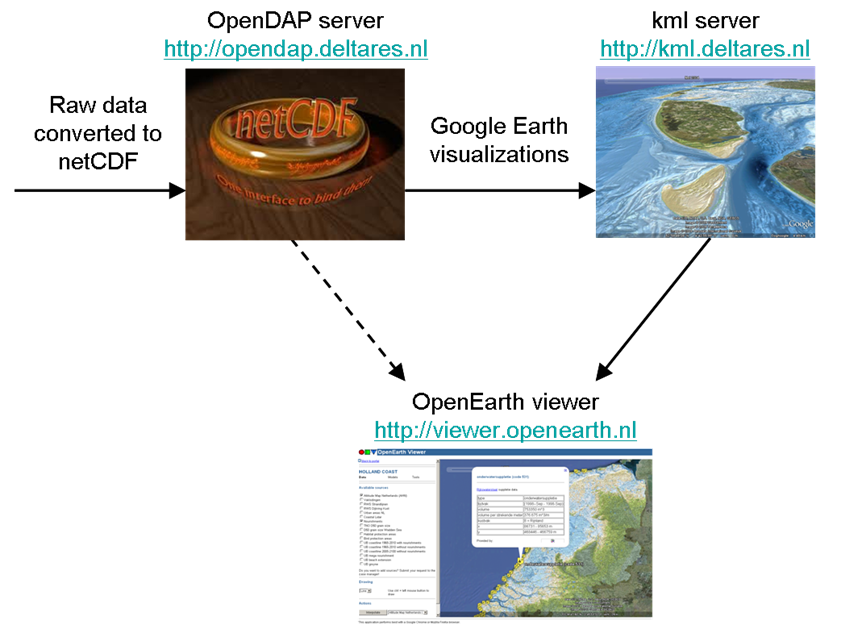
In (hydraulic) engineering studies and research and monitoring programs, many data, models and tools are collected and/or developed. The amount of information that is becoming available in this way is not always easily accessible for its users (i.e. project teams, program partners, clients, stakeholders). GoogleEarth based data and models that EcoShape has developed facilitate data management and visualisation in projects. GoogleEarth-based visualisation links to an OpenDAP sever where all data are stored, and a kml server where the visualisations are stored – following the OpenEarth principles.
Building with Nature interest
One of the three principle eco-dynamic development & design principles of Building with Nature is to interact differently: “Realisation of Building with Nature projects cannot be achieved without interdisciplinary collaboration and early and active stakeholder involvement!”. Bringing together people and knowledge from different disciplines (and hence different working methods) puts high demands on data management and dissemination. In order to meet those demands, Building with Nature has adopted the OpenEarth infrastructure for its data management. GoogleEarth based visualisation can be seen as an extension of this infrastructure, meant to facilitate accessible dissemination of information to end-users, which includes both Building with Nature partners and other stakeholders.