Lesson Learned
The objective of the Ecoshape innovation project is to learn more about efficient sand-nourishment, with added value for nature and leisure. The research themes are:
A. Predictability in the development of engineered habitats
B. Optimising design and morphological evolution
C. Perception of local community and visitors
In the read more you will find the lessons learned from the Hondsbossche Dunes within the three themes.
A. Predictability in the development of engineered habitats
In the Netherlands, since the late 90s, several sandy reinforcements have been realised. Examples are the ‘Kennemerstrand/duinen’, ‘Spanjaardsduin’, ‘Zandmotor’ (the so-called Sand Engine) and the ‘Hondsbossche Duinen’ which is addressed in this study. A number of other projects such as ‘Waterdunen’ and the ‘Prins Hendrik Zanddijk’ are still under construction. It is envisaged that in the near future more reinforcement projects will follow to compensate for the effects of sea-level rise in order to preserve a safe water defence. All these projects have been initiated for a different reason. Each individual design provides a combination of the three functions, namely coastal safety, nature, and recreation.
While the predictability of the morphological developments with respect to coastal safety is generally good where it concerns the direction and type of developments, it is rather moderate in terms of actual development speed. The (theoretical) controllability of morphological processes seems to be favourably although this assessment could not be made for all areas.
Regarding ecology however, e.g. habitat and nature development, the processes are generally well understood, but can be chaotic. The bandwidth in which (cascade) effects can occur, can be large. To counter undesirable developments, of course measures can be defined, but such an intervention would go against the overall nature concept and the original idea behind the projects, i.e. Building with Nature.
Since the relevant processes have long timescales (up to decades) it is not yet possible to draw conclusions, i.e. judge after only a few years (being the duration of this project). Therefore, whether interventions will be needed on a larger scale to maintain sand dynamics is not clear yet.
B. Optimising design and morphological evolution
The lessons-learned on the morphological evolution and design optimisation of the newly built dune area ‘Hondsbossche Duinen’ are mainly based on data of the dry beach and dune area, therefore determined by aeolian transport of sediment. The development of the underwater area was analysed briefly based on yearly transect data (Bodde et al., 2018b).
The most relevant findings of this study are addressed for a number of aspects, namely (i) physical processes, (ii) the impact of design measures and (iii) the impact of flood safety and subsequent design optimisation.
Physical processes
With respect to the dominant physical processes four main conclusions have been defined.
- The total volume of sand blowing into the dunes is determined by the supply of dry sand from the beach rather than by the local geometry of the dune body itself. In other words, the local geometry has only impact on the distribution of the supplied volume.
- Alongshore variation in net accumulation of sediment in the study area was observed. The orientation of the dune foot showed a correlation with the total accumulation of sand in the dunes where more accumulation was observed on locations where the shore orientation is closer to perpendicular to the dominant wind direction. The beach width also plays a role in sediment supply to the dunes. But because there is such an abundance of sand on the beach the beach width has not become a limiting factor in sand transport towards the dunes yet. However, locally a reduced beach width was found to reduce the dune growth rates. In other words, the large-scale configuration of the beach/dune area determines the supply of sand.
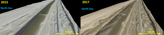
Measurement and image taken on May 24, 2015 (left) and August 11, 2017 (right).
- An average net dune growth rate (measured above the NAP+3 m level) of 33 m3/m1/year was observed in the first three years after realisation of the nourishment. Later observations correspond with the estimates that were defined during the project design phase. Based on the observed dune growth rates, estimates for future nourishments can now be made with a higher reliability since this additional dataset supports the findings of De Vries et al. (2012) and Van der Wal (2004). It is expected however that sediment accumulation rate will decrease in the coming years due to a reduction in the supply of especially fine sediments from the beach due to natural processes.
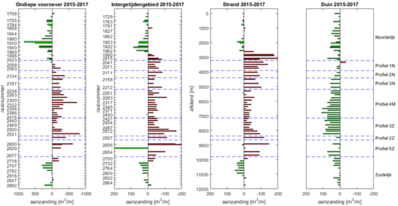
- The underwater area was not part of the scope of this research project and was analysed only briefly based on transect data, see the figure below. It was found that at least 50% of the total volume increase of the dune area originates from the underwater area below mean high water (MHW). Furthermore, the total dune growth volume is equal to approximately 1/3 of the total observed volume loss from the beach and underwater area.
Impact of design measures
With respect to the impact of a number of design measures the following conclusions have been derived.
- Alongshore variability in the design results in alongshore variable evolution after construction, and therefore in an alongshore variable dune landscape. This is expected to have a positive impact on ecological values (theme A) and public perception and appreciation of the project (Theme C) as well.
- On an average cross-shore profile, most of the sediment (70 %) was deposited on the seaward side of the foredune complex, mainly below the NAP+8 m level. The rest (25-30%) of the volume is deposited on the top of the dune, mainly on the seaward part. Only small amounts are deposited on the landward side of this first dune. This typical cross-shore deposition pattern is present for different cross-shore geometries. Only the exact deposition location (height in the profile) of the ‘70 % deposit’ on the seaward side varied.
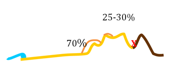
Typically observed cross-shore pattern of sand deposition
- The distribution of sediment deposits in the cross-shore can be used in the design phase to optimise the spatial design of the dune. Habitats or functions which require a dynamic system should be located near the seaward front, whereas functions which require limited or no sand supply should be placed at the landward side. In case dynamics are desired further landward, design measures can be optimised to stimulate transport of sand further into the dune area (f.e. dune slacks).
- The overall dune geometry can be optimised as well. Sand is mostly deposited in the lower parts of the profile, so a dune including a low dune on the seaward side creates a wider zone with sand deposits, creating a wider zone with dynamic development. On the other hand, from a safety perspective, a narrower, but high dune is optimal, because the dunes increase very little in height after construction, so the anticipated dune level should be present from the start. In, time, the aeolian deposits on the seaward side of the dune will lead to increased safety level.
- Variations in large scale geometry and local measures like brushwood screens, artificial relief features and vegetation can be applied to:- Influence the locations of sediment deposition;- Retain sand for coastal safety;- Prevent nuisance to users and local communities;- Stimulate differentiation in morphological development.
Depending on whether less or more sediment is required in more seaward or landward dune locations, one can choose between different measures and cross-shore profiles, which will trigger less or more changes in certain areas.
- Artificial Relief Features (ARF) are local, unvegetated depressions in the dune with an area in the order of 20-400 m2 and a depth up to 2 m. They trap sand and facilitate an increase in local sand dynamics. By stimulating local sand dynamics, they create height differentiation and varying boundary conditions for habitat development (theme A). An ARF is most effective when situated on the lower dune or on the seaward part of the top of the dune, where the supply of sand is higher. The initial shape/pattern of the ARF remains visible, at least in the first years after construction. To further stimulate a more natural look, the pattern and shape of constructed ARF should be as varied as possible.
- Vegetationor another measure like brushwood screens are very effective to locally trap large volumes of sand and are essential to retain the nourished sand in the dune and to capture sand supplied by aeolian transport. In the absence of vegetation less sand is captured, and a larger volume is transported further in cross-shore or alongshore direction and deposited elsewhere. The ARF’s are mostly unvegetated and create variations in sand transport further into the dune, showing that a variable vegetation pattern stimulates differentiation in the morphological development in the dune.
Flood safety and design optimisation
With respect to the impact of flood safety and design optimisation, the next conclusions can be drawn (Leenders et al., 2018):
- The Hondsbossche Dunes were designed for the current, legally required safety level, including a compensation volume for subsidence and local sea level rise of 0.3 m in the next 50 years. As a consequence, the initial design has a positive safety surplus.Based on the observed dune growth rates in the first three years after construction and the projected sediment deposition the coming years, it is expected that the natural dune growth rate keeps pace with the rising sea level and subsidence up to 2050, maintaining the initial high safety level.As such, the compensation volume for 0.3 m sea level rise that was applied in the design, might have been omitted. An important assumption is that the foreshore, intertidal area and beach are maintained at their current level by nourishments, which is standard practice in the Netherlands.
- Therefore, in future, similar projects, it may be possible to achieve a volume reduction in the design by anticipating on the natural dune growth rate. Since there is a large uncertainty in sea level rise scenarios, the need for additional nourishments in case of increased sea level rise, can still be assessed as part of the yearly monitoring programme and adaptive management, allowing for a flexible and adaptable coastal defence.
- Since windblown sand is mostly deposited in the lower parts of the profile the initial construction of narrow, high dunes at the seaward boundary is favourable. Over time, the aeolian deposits on the seaward side of this dune will lead to a gradual increase of the safety level.
C Perception of local community and visitors
Within this third theme two questions have been addressed, namely (i) how do stakeholders experience sand transport and sand deposition behind the dike, and how do their experiences relate to the monitored sand transport and sand deposition and (ii) what is the effectiveness of measures to reduce sand transport and sand deposition behind the dike (Lagendijk, 2016)?
Monitored and experienced sand transport and deposition
Before the Hondsbossche Dunes were constructed, 18 inhabitants and other stakeholders have expressed their concerns about sand deposition behind the dike.
Both interviews and monitoring results show that the amount of deposited sand behind the dike reduced in the years after construction. The amount of sand blowing towards the dike and over the dike was highest during the construction phase (2014 and 2015). Interesting fact is that the amount of blown sand near Camperduin was already decreasing from the year 2014. This is because substantial sand transport was present before the actual construction of the Hondsbossche Dunes. Creating these dunes and (especially) planting marram grass helped to trap the sand and thus reduce the sand transport from an early stage onwards.
With respect to the cross-shore distribution, sand transport rates are highest at the seaside of the dune area and decrease in the direction towards the dike (see also theme B). Over time, the accumulation of sand at crests of the most inland dunes (the high dunes) decreases, indicating that sand is transported less far inland as excepted. Measurements show that almost no sand is blown over the original dike, and that the amount of deposited sand behind the dike decreases exponentially with inland distance. Also, the interviewed stakeholders confirmed that the highest sand transport occurs near the beach and the first dune row. Here, blown sand can give nuisance for the beach restaurants. Within the dune area, sand has sometimes been found to accumulate on the cycle paths. In the nature area behind the dike (the Harger- and Pettemerpolder) almost no blown sand has been found.
With respect to the alongshore distribution, the amount of sand transport has been highest in the southern part of the Hondsbossche Dunes. This is also confirmed in the LIDAR measurements, which show that sand accumulation in the dunes is higher in the south than in the north. Near the dune valley, the sand gets trapped into the water and does not reach the inner dunes. The coarser sand in the northern dunes causes the amount of sand transport to stay limited, however. The municipalities both north and south of the Hondsbossche Dunes have received no or almost no complaints about blown sand. So, in the interviews there was no difference between the north and south part of the area.
With respect to the local effects it was found that on several places sand accumulation has occurred, particularly on the cycle path in the Hondsbossche Dunes. Especially in the first year after construction, the amount of sand on the cycle path was substantial. Often this occurred near a non-vegetated spot in the dunes that was located seaward from the cycle path (so called Artificial Relief Features). Several stakeholders called the sand accumulation on the cycle paths a nuisance, sometimes causing the cycle path to be closed off. Not only the cycle path, but also the foot paths that are used to access the beach were sometimes covered in sand. This caused high costs for the municipalities, who are responsible for the maintenance of these paths. The amount of sand on the cycle path has decreased since the first year after construction and the expectation is that this amount will decrease further over time.
Effectiveness of measures to reduce sand transport and sand deposition
Because of the concerns of the stakeholders that the construction of the Hondsbossche Dunes could cause sand to be blown behind the dike, the design included measures to trap the sand and reduce sand transport rates. Below, the effectiveness of these measures is described based on measurements and interview responses.
The valley between the dike and the high dune forms a buffer zone to trap blown sand. Although some sand has accumulated at the landward side of the high dune, only a small amount of sand has been deposited on the dike. And incidentally some sand has been recorded on top of the dike or on the landward side of the dike. Sand accumulation on the dike has been higher in the south than in the north. In conclusion, the buffer zone seems to be effective in trapping the sand.
Straw bales were placed in the buffer zone between the high dune and the dike, to trap sand. Because the amount of deposited sand in this valley was so low, however, we cannot conclude if these bales are effective in trapping sand. They did work as wind break and created a sheltered area that stimulated vegetation growth.
Paper pulp has been used to reduce sand transport directly after construction and before the marram grass had been planted. The paper pulp was deposited on the sand to reduce sand transport. One year later, some remainders of this paper pulp were still found between the shrubs and marram grass. The measure was considered partly effective; the effectiveness had been reduced significantly by breaking the pulp cover due to driving over it with heavy machinery.
Marram grass has been planted in the dunes to trap the sand. The marram grass looks more vital in the south part of the Hondsbossche Dunes than in the northern part. At the sea side, the marram grass can hardly keep up with the high amounts of accumulating sand, allowing for the sand to be blown further land inward. All stakeholders have confirmed that the marram grass has been effective in trapping the sand, already from the moment of planting. Some stakeholders note that the less vital marram grass in the north traps less sand compared to the vital marram grass in the south. Therefore, it is recommended to consider what the best conditions are to plant marram grass, to make sure the plants will remain vital.
Several species of shrubs have been planted at the landward side of the high dunes. Most of these shrubs have died, however. Only sea buckthorn has survived. These shrubs are more vital in the south than in the north. Stakeholders mention that the shrubs indeed help to trap the sand.
The sheltered depressions trapped more sand after construction than the vegetated parts of the dunes. They cause local wind dynamics and influence the sand transport locally. Often these sheltered depressions show both accumulation and erosion and cause sand deposition further landwards (downwind). In cases where the depression is located close to a cycle path, it can cause sand deposition on the cycle path. This effect can be reduced by planting part of the sheltered depression, but it would be better not to construct any of these depressions close to cycle paths (or other parts where sand deposition is not appreciated).
Screens made from willow branches have been used to stimulate sand deposition. The screens have been very effective and were often fully covered in sand (after which they do no longer trap sand). They could have been used in a more effective way by placing new screens after the first ones were covered, and by placing screens on strategic locations to reduce nuisance (e.g. near beach restaurants or paths).
Overarching lesson learned
When a project combines different functions trade-offs have to be made. The Hondsbossche Dunes combine water safety, recreational value and nature value. In several occasions you will have to choose which function prevails. Therefore, even though the different functions might be valued equally, on some occasions you will have to choose between the functions.