Overview
Location: Oosterschelde (Eastern Scheldt), the Netherlands
Date: 2008-2012
Involved parties: Deltares, IMARES, Rijkswaterstaat, NIOZ (former NIOO-CEME), EcoShape Technology Readiness Level: 9 – actual system proven in operational environment
Environment: Rivers & Estuaries
Keywords: Benthic ecology, tidal flat restoration, estuary protection, measures against erosion, biodiversity, morphology, hydrodynamic model
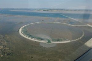
The nourishment on the Galgeplaat was designed in a circular shape. First, a protective bund of sand of approximately 1 m high was built, forming a ring with a diameter of 450 m. This ring was filled with sand during the flood phase of the tidal cycle and spread by bulldozers during the ebb phase. This allowed for a controlled construction of the nourishment, as an increase in the concentration of suspended matter had to be avoided because of nearby commercial mussel beds.
Traditional working methods, while effective from a technical perspective, provide less control over the spreading of fine sediments than the work method implemented in this project, with the perimeter of sand.
Abstract
Tidal flats are valuable habitats and are important for coastal protection. The total area of tidal flats is decreasing worldwide due to various problems like sea level rise, coastal squeeze, subsidence by gas extraction and erosion initiated by man made constructions. The construction of a storm surge barrier and compartmentalization dams in the Eastern Scheldt in the 1980s is one example of a man made structure that resulted in a change in hydrodynamic conditions of the Eastern Scheldt estuary and hence the sediment equilibrium. As a result, channels are filling in and tidal flats inside the estuary are eroding. Nourishing tidal flats with sediment might be a promising solution to mitigate these effects.
To test this approach, a small area of the Galgeplaat, a tidal flat in the Eastern Scheldt, was nourished in 2008 with 130.000 m3 sand dredged from adjacent channels over a total area of 150.000 m2. The processes of sediment distribution on the flats and benthic recolonization are coupled and interact with each other. Therefore the design challenge is to find an optimum to reduce the initial impact of the nourishment on the benthic fauna, while optimizing the distribution of the sand over the tidal flat by wind and waves and the subsequent recovery of benthic life.
The saltmarshes and intertidal flats in the Eastern Scheldt are important and unique resting and feeding areas for seals and wading birds such as oystercatchers and curlews. These shallow areas also provide important additional protection against coastal flooding because they attenuate wind waves before they reach the dikes.
The construction of the storm surge barrier in the Eastern Scheldt has changed the hydrodynamics of the system. Tidal flow velocities in the channels have decreased by some 30% and the sediment transport capacity, important for accretion of the intertidal flats, has shrunk by as much as 75%. Moreover, the storm surge barrier itself acts as an almost perfect block to sediment exchange between the outer delta and the basin. As a consequence, the estuary lacks the sediment transport capacity as well as the sediment availability to maintain the original balance between erosion and sedimentation. While erosion by waves generated inside the estuary continues, the mechanisms building up the tidal flats have dramatically weakened. As a result of this imbalance, saltmarshes and tidal flats in the estuary are eroding. Between 1986 and 2010 the intertidal area has decreased by 1380 ha and the flats are reducing by approximately 1 cm in height per year (De Ronde, et al., 2011). Moreover, wave action tends to erode the higher parts of the flats hence flattening the relief, which further reduces the foraging time for birds.
Without human intervention, the intertidal area is expected to decrease by about 50 ha to 100 ha per year in the coming years. From the 11,000 ha of intertidal area in 1986 only 75% (circa 9,000 ha) will remain by 2060 (De Ronde, et al., 2012).
The reduction of the intertidal area in the Eastern Scheldt is undesirable for both nature and safety reasons. Rijkswaterstaat (Dutch National Water Board) defined several types of mitigation measures (Van Zanten and Adriaanse, 2008):
- hydraulic-engineering measures (e.g. enlarging the flow capacity of the storm surge barrier, filling the scour holes on either side of the barrier, protecting the bed, or opening the Philipsdam in the back of the estuary);
- filling the channels with sand from sea;
- nourishing intertidal areas;
- protecting intertidal areas with biogenic reefs or hydraulic-engineering structures (rock, pole screens);
- compensation by developing comparable nature area outside the Eastern Scheldt.
Nourishing tidal flats is one of the solutions to limit the loss of intertidal areas. Nourishment of beaches is increasingly used to combat shoreline erosion, but in intertidal habitats so far nourishments have been hardly applied (Ysebaert et al., 2009). Little is known about the effectiveness, feasibility and costs of these measures. The Directorate-General Rijkswaterstaat of the Ministry of Infrastructure and the Environment, the authority responsible, decided to carry out a pilot nourishment on the Galgeplaat.
The Galgeplaat nourishment
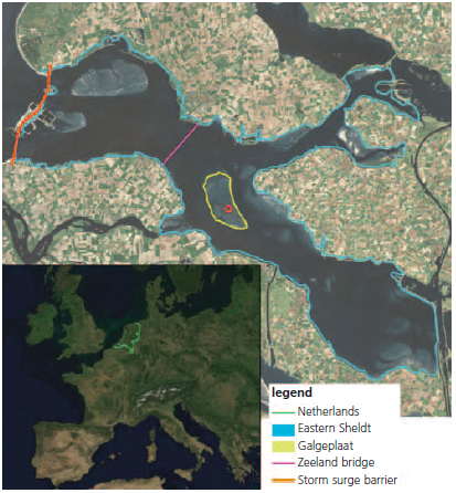
The Galgeplaat is one of the eroding intertidal flats in the Eastern Scheldt. Between 1985 and 2001 the area of the Galgenplaat shrunk from 1000 to 964 ha and its mean height was lowered by 0.33 m (approx. 1 cm/year) (Van Zanten and Adriaanse, 2008).
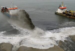
In 2008 a trial nourishment was carried out on the Galgeplaat by Rijkswaterstaat, with the aim to reduce the pace of erosion. The Galgeplaat was chosen because it is monitored and investigated over the years, so there is a significant amount of background knowledge. In addition, planned maintenance dredging of the adjacent channels for shipping meant enough sediment was readily and easily available for this trial nourishment.
The objective of Rijkswaterstaat is to answer the following questions with this experimental nourishment:
- How is the nourished sand moving and spreading over the intertidal flat?
- What is the influence of the nourishment on the emergence time and the emerging area of the flat?
- What is the influence of the nourishment on the wave height?
- What is the effect of the nourishment on the foraging behavior of birds on the flat?
- How and how fast do benthic habitats recolonize the nourished area?
- What is the effect of the nourishment on nearby commercial mussel beds?
- Is nourishing intertidal areas in the Eastern Scheldt an effective and feasible measure to structurally compensate the negative effects of intertidal flat erosion?
In addition, Building with Nature took advantage of the opportunity to use this innovative nourishment to gain new knowledge on the driving processes of a tidal flat and the integration of morphological and biological processes. This is done by assessing and modelling the ecological and morphological impact and effectiveness of the nourishment in preserving valuable intertidal areas. The main objectives were:
- generating sufficient system knowledge from monitoring data to explain the how and why of the observed biological and morphological processes;
- quantifying relationships among physical and ecological parameters (biogeomorphologic feedback mechanisms);
- making a first step in generating an ecologically relevant morphodynamic model for an intertidal area.
Building with Nature seized this opportunity to use this innovative nourishment to gain new knowledge on the driving processes of tidal flat morphology and ecology and the mutual interaction of morphological and biological processes. This is done by monitoring, modelling and analyzing the ecological and morphological impact of the nourishment and assessing its effectiveness in preserving this and other valuable intertidal areas. The main objectives were:
- deriving sufficient system knowledge from monitoring data to explain the why and how of the observed biological and morphological processes;
- quantifying relationships among physical and ecological parameters (biogeomorphologic feedback mechanisms);
- taking a first step in generating an ecologically relevant morphodynamic model for intertidal areas.
The activities in this project contribute to the BwN-programme objectives by generating ecosystem knowledge, design rules and practical expertise.
The data used in this Building with Nature case are the monitoring data from Rijkswaterstaat and additional benthic samples collected and analysed by Building with Nature. In addition, the data produced by the Argus database are essentially geo-referenced JPEG-pictures (or movies), saved in the Argus-database together with information on time and camera settings.
Consequences for fauna
The intertidal areas in the Eastern Scheldt are rich in benthic flora and fauna. They form a food source for higher trophic levels like fish and birds. One of the important intertidal benthic species is the cockle Cerastoderma edule. Since 1992 the policy is to reserve the cockles primarily as food for waders, except when high the stocks are high. Other characteristic benthic macrofauna species include worms like the lugworm Arenicola marina, bivalves like Macoma balthica, and in the shallow pools crustaceans like Crangon crangon.In recent decades the Pacific Oyster Crassostrea gigas has spread in the Eastern Scheldt, and now covers about 10% of the intertidal area.
Most benthic fauna have specific preferences regarding soil composition, hydrodynamics and emergence time. The latter is changing when the tidal flats are lowered and flattened due to erosion. Between 2001 and 2045 the emergence time is expected to reduce from almost 9 hours to less than 5 hours per day (Van Zanten and Adriaanse, 2008). The loss of intertidal area will cause a substantial change in species composition in this area. Macrofauna living in the lower intertidal areas (e.g. the Pacific Oyster) will take advantage of this temporary increase in living area, but species preferring higher areas will lose their habitat. This will influence their condition and the size of the population will decline (Van Zanten and Adriaanse, 2008).
The erosion of tidal flats also has an effect on birds foraging on them (mainly waders). As the area and the relief of the flats decrease, birds have less time to forage. The number of waders is predicted to decrease drastically when the intertidal area disappears (Van Zanten and Adriaanse, 2008; De Ronde et al., 2012).
Although the nourishment will reduce the erosion rate of the intertidal flats and increase the emergence time in that area, it will bury and kill all benthic fauna within its footprint. After some time the benthic fauna is expected to recolonise the area. Both benthic recolonisation and changes in physical processes have been monitored and analysed, before and after the Galgeplaat nourishment.
Results of benthic sampling
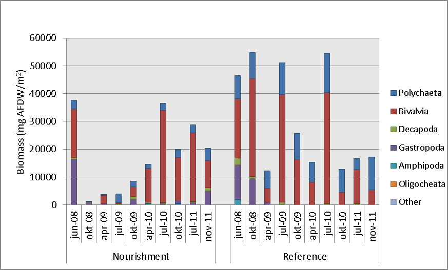
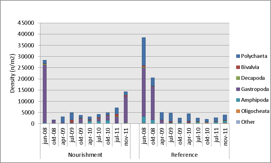
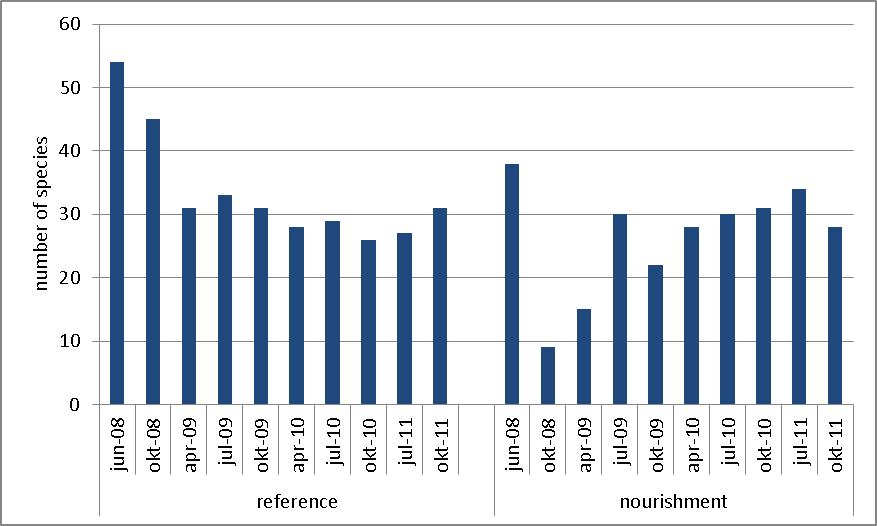
Sampling just before the start of the nourishment (June 2008) at locations within the planned nourishment area and in the surrounding area revealed similar chlorophyll-a concentrations, total biomass, species richness (i.e. total number of species present) and total density of benthic macrofauna. The chlorophyll-a concentration, a measure for the presence of microphytobenthos, dropped drastically after the nourishment and recovery to pre-nourishment values was still ongoing after 2 years. The nourishment killed almost all benthic macrofauna within its footprint. Shortly after the nourishment, in September and October 2008, only few organisms were observed in the samples, mainly being adult mud snails (Hydrobia ulvae), migrating from the surrounding undisturbed area onto the nourishment. This species was very common in the summer of 2008 and is capable of dispersing over long distances by e.g. floating. In 2009 we observed a further recolonisation of the nourishment by benthic macrofauna. The density matched the density of the reference area, but in both areas it was not as high as prior to the nourishment. The low density observed in the reference stations in 2009 and 2010 was due to the almost complete absence of Hydrobia ulvae, by far the most dominant species in the summer of 2008. Hydrobia ulvae is known to show great year-to-year variation in the whole Eastern Scheldt, and therefore these fluctuations are not abnormal (Troost and Ysebaert, 2011). Both biomass and species richness was in 2009 still lower on the nourishment. One year later, in July and October 2010, both biomass and species richness were similar to the reference area, but species composition and dominance still differed. Data from 2011 will be presented by Mesel et al. (in prep) as soon as available. The recolonisation of the benthic fauna on the nourishment showed a very patchy pattern, with some sites having a relatively rich fauna, whereas others showed hardly any macrofauna. The latter were mainly situated on the higher northern part of the nourishment, where the sediment dries out faster during low tide.
Based on images from the Argus-Bio station we were able to link the occurrence of wet and dry areas to the position of the sampling locations for the benthic macrofauna. The wet and dry areas refer to the state of the sediment during low tide. Some sites drained quickly after the water had retreated, while at others remained wet for a longer period of time. The recovery of the benthic macrofauna was different in the wet and dry areas. More particularly, the number of species, biomass and total density of the macrofauna recolonizing the nourishment was higher in the wet areas.
Further information on the relationship between sand nourishments and ecology can be found in Knowledge – Biogeomorphological effects of nourishment, NL.
Consequences for morphology
Wave and current action were expected to spread the nourished sediment and heighten the surrounding area. On a time scale of a couple of years the nourishment would compensate the erosion of a large part of the tidal flat and keep the flat above low water.
Results field measurements
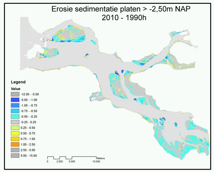
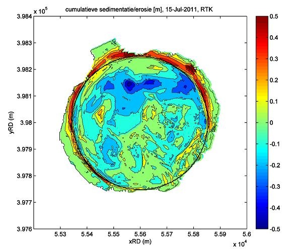
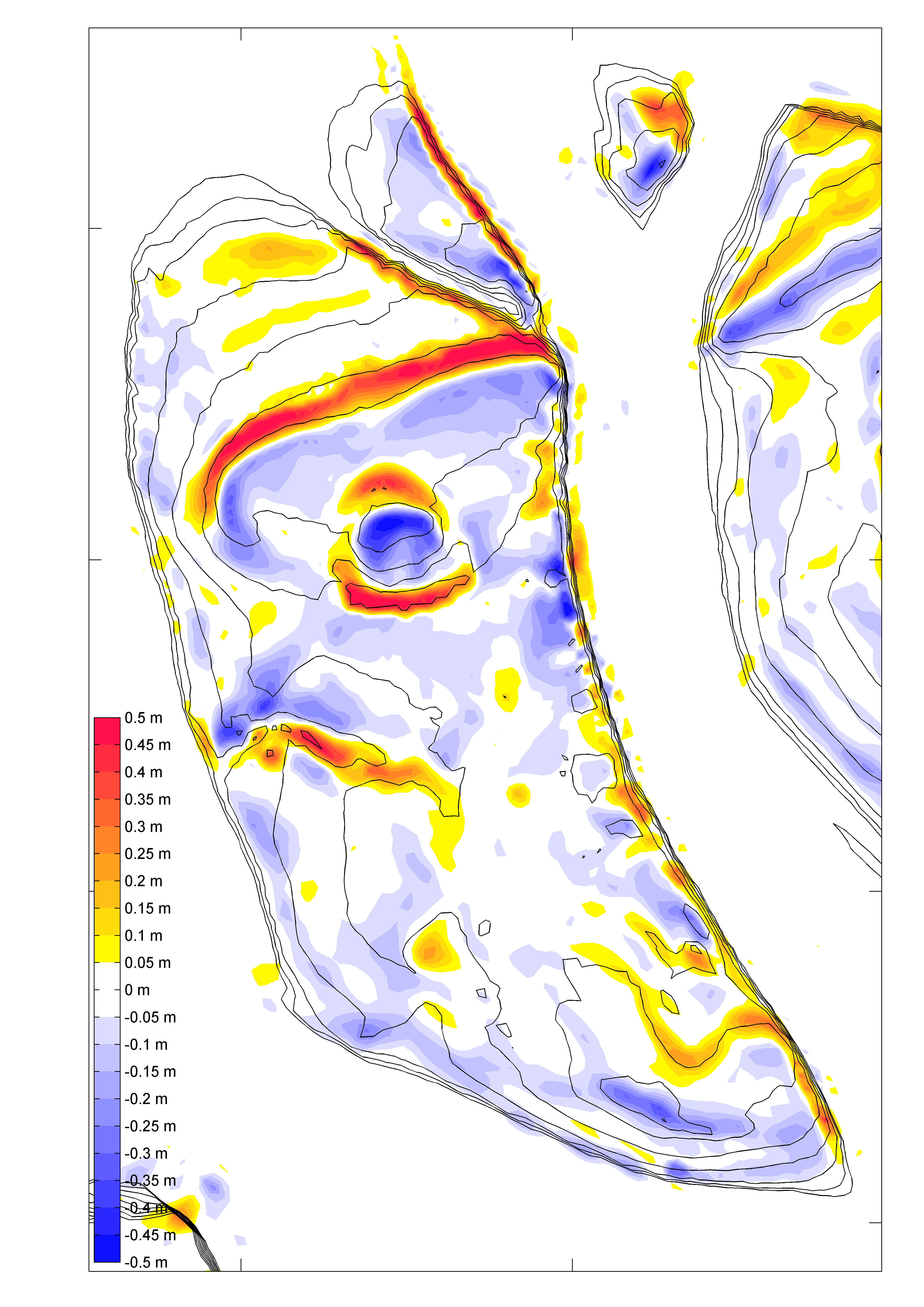
Initially, the bed level has been raised by the nourishment from – 0.5 m NAP to + 0.5 NAP on average. After two years, only minor morphological changes of the nourishment were observed. Some redistribution of sediment occurred, but the overall change in sediment volume of the nourishment was only some 2 % (Holzhauer, et al., 2009 and 2010, Van der Werf, et al., 2011).
Field measurements showed that the maximum height of the nourishment slowly decreased in time. Erosion occurred mostly on the higher part in the north, whereas the southeastern part experienced some sedimentation.
Most of the eroded sediment is being transported to the north east and deposited along the edge of the nourishment.
The silt content of the sediment dropped directly after the nourishment, but returned to pre-nourishment values within a year (Holzhauer et al., 2010).
Results morphological modelling
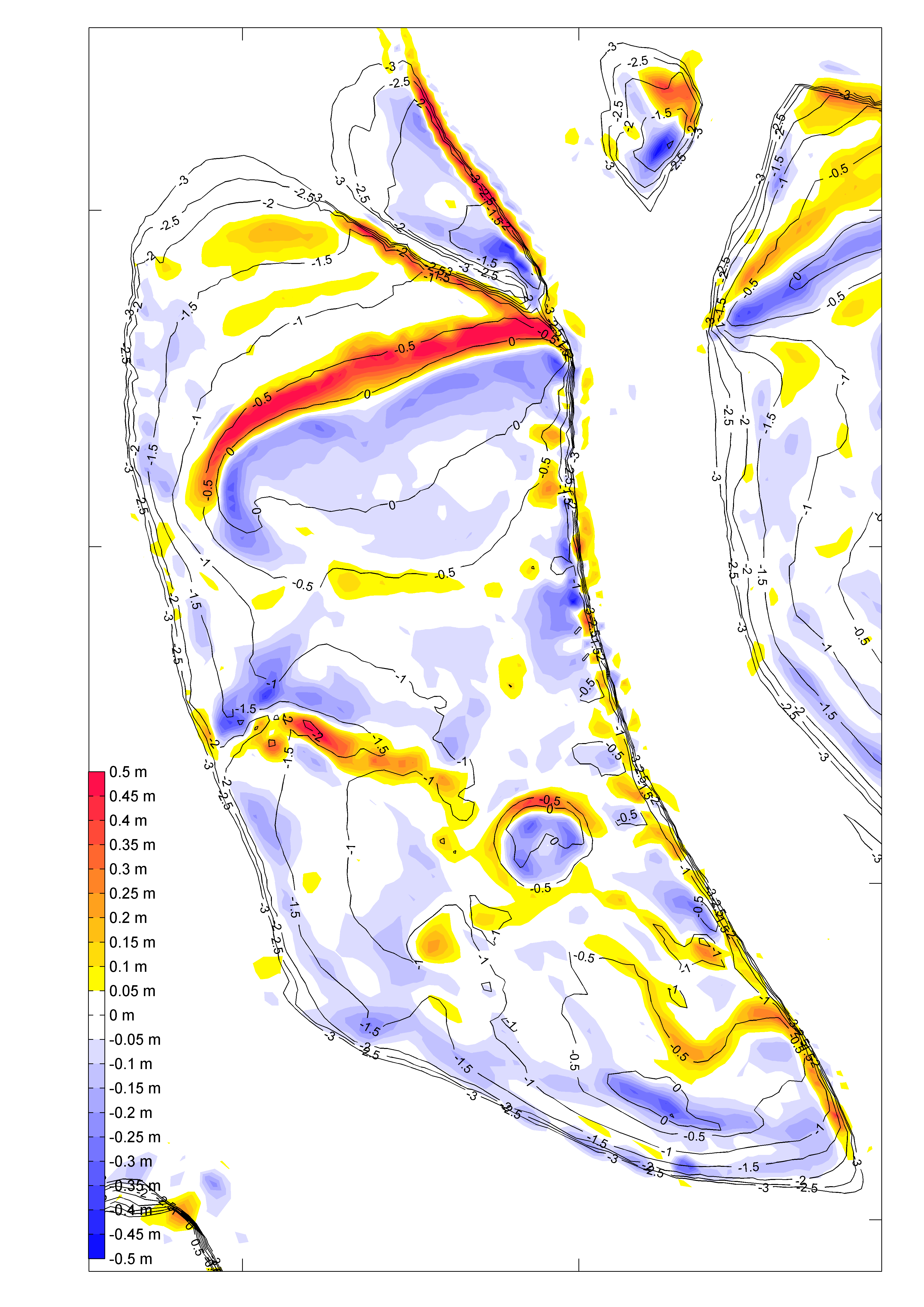
The observed changes in hydraulic, morphological and relevant abiotic parameters provide information on the effects of the nourishment. An objective of the Building with Nature programme was to develop a modelling tool to support the planning and design of future nourishment, based on the observations from this one. Using the model bed roughness, developed under this project, and others such as the ANT-project(Cronin, 2011; Das, 2010), the effects of location, dimensions and sediment type of a nourishment were described including the influence of wave and current action. Simulations show that locally generated waves in combination with tidal currents play an important role in the transport of sediment around the flat, whereas tidal currents alone have hardly any effect on erosion. Qualitatively, the model is reproducing the general erosion and sedimentation patterns on the nourishment, as the sediment spreads in a northerly direction onto the intertidal flat, in line with the cumulative sedimentation/erosion plot from field measurements.The model was also used to estimate the effect of a hypothetical nourishment elsewhere on the Galgeplaatmodel. In terms of volume and height changes around the nourishment, placing it at the northern part of the Galgeplaat had a much larger effect than at the current location. This shows that the bed level and the location of a nourishment on the intertidal flat can play an important role in its morphological effects. The impact of the nourishment on existing morphodynamics was also investigated with the model. Although in reality the nourishment is undergoing less morphological change than expected, the model is qualitatively reproducing the sand redistribution pattern and the trend is also correctly simulated at several monitoring locations on the nourishment. Despite the overestimation of the rate of change, the model is a useful tool to examine the processes determining the redistribution of nourished sand and to test nourishment scenarios. Suspended sediment transport patterns correlate with the significant wave height around the nourishment, which indicates that the wave-induced near-bed orbital velocities influences the transport more than the current velocities alone.
The inclusion of biological features, such as oyster reefs, also had an impact on the simulation of current magnitudes over the intertidal flat and hence the patterns of sedimentation/erosion. As these features were included by modifying the bed roughness, only one type of effect is taken into account, the effect on the roughness height of the bed. Other effects are, for instance, sediment trapping, vertical mixing of sediments and modification of sediment properties.
Consequences for safety
The loss of intertidal area also involves safety issues. When dikes border on wide or deep waters like de Eastern Scheldt, waves can run up high during storms. When the flats erode, become lower and finally disappear, those dikes will be exposed to higher waves and so may need upgrading in the coming decades (Van Zanten and Adriaanse, 2008).