Practical Applications
The nature conservation plans in the Dutch Eastern Scheldt estuary serve as an example to illustrate the application of the Nature Index tool. The illustration follows the consecutive steps of the Nature Index tool.
Step 1 : Defining the project
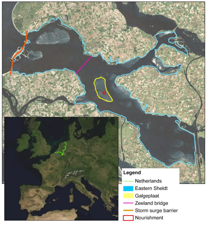
After the 1953 flood in the southwest of the Netherlands, a movable storm surge barrier was built in the mouth of the Eastern Scheldt, at that time a branch of the Rhine-Meuse delta (see figure). Additional works have separated the Eastern Scheldt from the other branches of the delta and have turned it into an elongated tidal basin. The works have increased flood protection in the area and stimulated recreation (sailing, diving, etc.). Several decades later, however, a downside of this icon of civil engineering became apparent: the reduced tidal flow in the estuary requires less wide channels than before and the narrowing of the channels goes at the expense of the intertidal flats. This was foreseen before construction, but it was expected to be a temporary effect that would be compensated once sediment from the outer delta would reach the shoals. Now that the barrier turns out to act as an almost perfect block to in- and outgoing sediment transport, the expected supply of sediment from the outer delta does not take place and the system faces a permanent sand deficit.
This has consequences for the unique and highly valued ecosystem in the area and for the flood defence system. First, the tidal flats and intertidal area are of vital importance to wading birds, which feed on organisms exposed during low tide. The decrease of the intertidal area induced by the sand deficit causes a decline of the foraging area for more than 100.000 waders. Moreover, the loss of relief of the intertidal shoals, which takes place at the same time, reduces the time available for foraging. Second, the loss of intertidal area results in less wave damping and a heavier wave attack on the downwind dikes. This may have consequences for the maintenance of those dikes.
The Dutch government, represented by its agency Rijkswaterstaat, aims to develop a policy for conservation of the intertidal areas. Scientists expect that – without intervention – almost all intertidal area will be lost by the end of this century. Sand nourishment on top of the intertidal shoals is one measure to compensate for erosion, be it only with a temporary effect. A pilot application has been realised on the Galgeplaat, one of the major shoals in the basin. Shoal nourishment will have a positive effect on nature in the long run, but a negative short-term effect (burial) in the nourished area. This case description is real, but some of the numbers in this document, especially those for the ecotope quality, are necessarily fictive or based on an educated guess. The nature valuation presented below was performed in 2012, which was still early days for the ecological part of the sand deficit study.
Step 1a: map the project area and its ecotopes
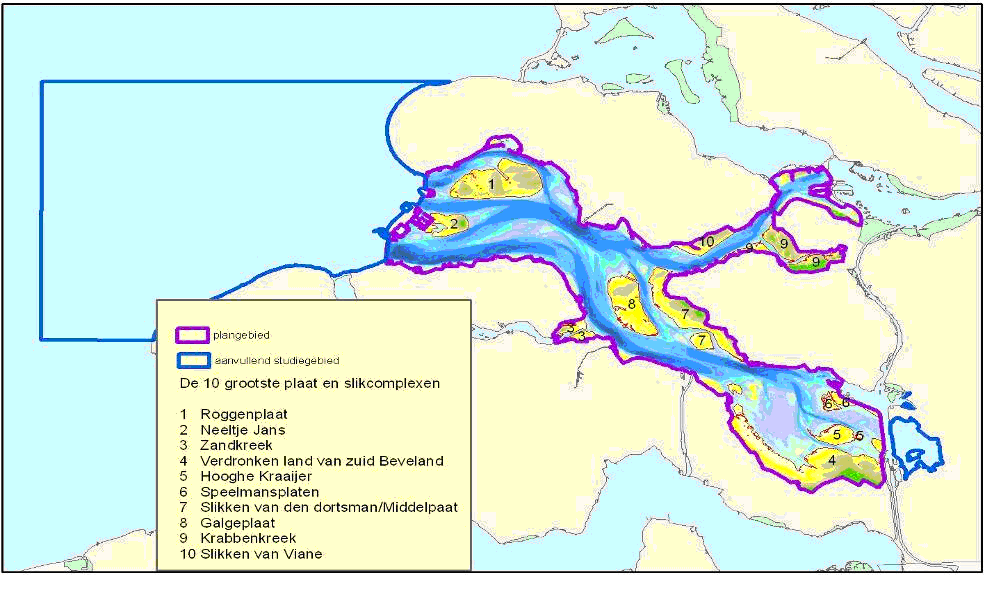
The figure on the right outlines the boundaries of the project area of the shoal nourishment case study (the Eastern Scheldt estuary) in purple. The total area amounts to 35.000 hectare and covers the entire the Eastern Scheldt estuary area outside the primary dikes. Both the nourishment and the sand extraction take place in this area. The area within the blue contour in the figure is the back-up location for sand mining if insufficient sand is available in the Eastern Scheldt estuary. This scenario is not included in the example case study. Both Natura 2000 and the Water Framework Directive have formulated goals for the Eastern Scheldt estuary. These provide input for determining the ecotopes.
Nature 2000
The Eastern Scheldt estuary is a Special Protected Area (SPA) within the Natura 2000 network. Natura 2000 is an ecological network of protected areas in the territory of the European Union. Member states are required to maintain SPAs in favourable state of conservation. The shoal nourishment aims at contributing to the Natura 2000 goals of the Eastern Scheldt estuary for the ecotope (habitat) ‘large shallow inlets’ profile document H1160. The quality objective for this ecotope is the conservation of the present tidal flats and channels in both variance and area. Essential for the ecotope quality are gradients in morphology (tidal flats vs. deeper channels), processes (dynamic vs. sheltered) and soil conditions (sand vs. mud). The conservation of the ecotope ´large shallow inlets´ is a precondition to (and serves to) maintain bird populations, another Natura 2000 goal in the area. The quality of the ecotope is mainly judged in the light of conservation of these bird populations. The Natura 2000 profile document (2008) provides a description of this habitat in a good state regarding structure and function:
- presence of tide;
- presence of natural channels;
- variation of sandy and sludgy parts, including transition areas;
- variation in height with both tidal flats and permanently flooded area;
- variation in high- and low-dynamic area;
- good water quality (transparency, salt);
- presence of sea grass and ruppia fields
- presence of rich mussel beds;
- presence of algae or a layer with diatoms and cyanobacteria;
- presence of species: benthos, fish, birds, mammals.
Water Framework Directive (WFD)
All water bodies in the EU have received a classification as WFD water type. The Eastern Scheldt estuary is a WFD water type ‘coastal water, shielded and polyhaline (K2)’. The WFD sets nature conservation goals for each of its water types. The following goals of the Eastern Scheldt estuary are relevant for the shoal nourishment case study: a balance between intertidal area/ shallow water/ mussel beds, % of natural coastline and hectares of sea grass area. The WFD sets target values for the formulated goals based on a realistic reference situation, which is deduced from the natural (historic) reference situation. The degree of goal realisation is expressed in % of the target value.
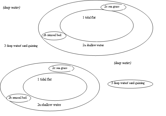
The level of detail of the WFD conservation goals fits this analysis best and therefore it is taken as the basis for further analysis. The description of the habitat in Natura 2000, however, is more comprehensive and includes the ecotope deep water that is subject to sand extraction activities. We consider the two documents as complementary, and supplement the WFD ecotopes with the deep water ecotope defined in Natura 2000. The figure on the right visualises the ecotopes schematically. Not all deep water is subject to sand extraction activities; therefore only a few patches are included in the project area. Note that the figure is schematic, and only shows two tidal flats and sand extraction areas, instead of the multiple areas that actually occur in the Eastern Scheldt estuary.
Step 1b: define the reference situation and the design alternatives
Scenario 1: Reference situation: autonomous development without tidal flat nourishment
In this situation no tidal flat nourishment takes place and therefore the tidal flat area (ecotope 1) in the Eastern Scheldt basin decreases strongly. In addition, the sand deficit reduces the duration of the dry stage and increases the speed of flooding. So there will be less food and less time to forage on it. Both effects are detrimental to the wading bird population. In 1986, the tidal flat area was more than 11.000 hectare. By 2011, about 1.100 hectare had been lost. Without interventions, half the intertidal area will have disappeared in 2050. Before 2100, scientists expect the intertidal area to have come down to 1500 hectare, at which point a new equilibrium state will have established (Van Zanten & Adriaanse, 2008). The submergence of tidal flats increases the shallow water area (ecotope 2). The deep water area (ecotope 5) will not increase or decrease significantly.
Scenario 2: Shore alternative: nourishment of tidal flats along the shoreline
In this alternative the nourishment is limited to the tidal flat areas directly adjacent to the shoreline, 500 hectares in total. The nourishment contributes to nature value as well as flood safety. The nature quality effects in this alternative are both permanent and temporary. The tidal flat area (ecotope 1) still reduces permanently, since the nourished volume is relatively small. In addition, the nourishment activity has two temporary negative effects on the tidal flat area. Firstly, burial by sand causes a temporary loss of species (Holzhauer & van der Werf, 2009). After completion, species recolonise the sand layer within a period of about 3-5 years. This recolonisation rate depends on the thickness and characteristics of the sand layer, the physical distance to the surviving ecosystem and the migration characteristics of surviving fellow species. Secondly, sand transport away from the nourishment may disturb the wading birds and mammals (seals) in the surrounding tidal flat area. The actual disturbance also depends on the timing of the activity.
The shallow water area (ecotope 2) increases when tidal flats become submerged. As this will not be the case for nourished areas, this effect will be smaller than in the autonomous development. The nourishment therefore has a temporary negative effect on the shallow water area. Depending on how the nourishment is realised, the activity results in more or less suspended matter in the water column directly adjacent to the nourished area. The resulting turbidity may temporarily affect benthos and fish, and if much of this sand is deposited it may also harm filter feeders (mussels, oysters).
The deep water area (ecotope 5) will not increase or decrease significantly. The sand extraction does have a more or less permanent negative effect on the borrow area. The benthos in the borrow area is probably destroyed completely and, depending on the depth of the sand pit, will take time to recover or will not recover at all. In addition, dredging may have a temporary negative effect via the turbid plume it creates. Depending on the intensity and the duration of the ensuing stress, this may affect benthos and fish (see also the tool Species Response Curves for Seagrass).
Scenario 3: Tidal flat alternative: nourishment of all tidal flats
In the tidal flat alternative, the aim is to maintain the current tidal flat area (10.000 hectare) and its quality. To maintain the current area, 8.500 hectare tidal flat is nourished. The other 1.500 hectare does not erode since these flats are located in sheltered areas. The tidal flats are nourished one by one. Nourishing the whole area at one time is both unfeasible (in terms of amount of sand required) and undesirable (in terms of environmental damage). For this case study example, the maximum area affected by a single nourishment is set at 10%. Furthermore, after a number of years the nourished areas have to be re-nourished for maintenance. The ratio tidal flat/ shallow water in this alternative remains the same as in the current situation. The negative side-effects of nourishment and sand mining are similar to those described for the shore alternative.
Step 1c: define components and system relations for each ecotope
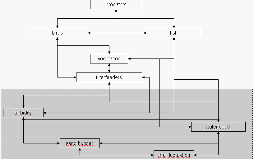
First, the biotic players in the plan area will be identified. Note that their interrelations are not necessarily predator-prey related, but can also be non-food relations such as vegetation providing shelter for fish to grow up. In the biotic domain, the most important players are:
- filter feeders that affect and are affected by turbidity and are an important food source to birds;
- vegetation, which is both legally protected (Zostera spec. and Chara spec.) and important as food source, habitat for fish and water quality filter;
- fish, which are an important food source for birds and seal, and feed on filter feeders and vegetation;
- birds, highly diverse, most of which are legally protected and feed on filter feeders, vegetation and fish.
- predators, mainly seal (legally protected), which feed on fish and are at the top of the local food chain.
The second step is to define the most important abiotic influences. These can be either natural or human-induced. The focus of this step is to identify the abiotic parameters that will change over time. The Eastern Scheldt estuary system can roughly be defined as dynamic, brackish and semi-terrestrial. The driving processes are:
- tide: not as strong as before the storm-surge barrier, but still present. Tidal fluctuation influences water depth and morphology;
- water depth: influenced by tidal fluctuation and morphology, affects vegetation, birds and filter feeders;
- salinity: has decreased since the construction of the storm-surge barrier, and is not influenced by any of the above;
- turbidity: mainly due to suspended particles, influenced by water depth and morphology; affects filter feeders, vegetation and fish.
Step 1d: define the time period of the analysis
The Dutch government considers nourishment as the policy line for the coming decades. Other alternatives, such as adaptation of the Delta works, come in view in 2100 at the earliest. Nourishing requires regular maintenance and therefore is a continual activity with long-term effects. Therefore it was decided to start the analysis in 2010, at the start of the shoal nourishment case study, and take a time frame until 2100.
Step 1e: quantify the ecotope areas per alternative over the time period
The table below presents the areas of different ecotopes per scenarios over time:
| ecotope | area (ha in 2010) | autonomous development (ha in 2100) | shore alternative (ha in 2100) | tidal flat alternative (ha in 2100) |
| 1. tidal flats a. tidal flat b. suppleted tidal flat | 10.000 10.000 0 | 1.500 1.500 0 | 2.000 *** 2.000 0 | 10.000 10.000 0 |
| 2. shallow water c. shallow water d. sea grass e. mussel bed | 8.000 * 7.629 211 350* | 16.500 15.779 21 350 | 16.000 15.279 21 350 | 8.000 7629 21 350 |
| 3. deep water a. deep water b. sand gaining | 850 850 0 | 850 850 0 | 850 825 25 | 850 0 850** |
| Total | 18.850 | 18.850 | 18.850 | 18.850 |
Starting points in completing the accompanying excel spreadsheet are in general:
- submerged tidal flats become shallow water;
- the recovery time of a nourished tidal flat is 5 years, thereafter the area is completely recovered and becomes a tidal flat again in the spreadsheet.
Specific starting points for the shore alternative are:
- the nourishment of 500 hectare tidal flat takes place in 2015 and is repeated in 2060. This area does not submerge in the period 2015-2100;
- a sand borrow pit of 25 hectare is dug in 2015 and deepened in 2060.
Specific starting points for the tidal flat alternative are:
- a maximum of 10% (1000 hectare) of the tidal flat area is affected by one nourishment. The 8500 hectare of tidal flats at risk are nourished in two rounds, where already submerged area is treated first. After the recovery time of 5 years, a new area of 1000 hectare is nourished. In the period 2015-2100, every hectare is visited twice. After the second nourishment the area remains intertidal until 2100;
- a sand borrow pit of 50 hectare is dug for every nourishment round.
Step 2: assessing change in ecotope quality
In this part of the analysis, the quality change of the ecosystem over time will be analysed for each alternative. After the ecosystem is defined (see step 1), first the abiotic parameters will be discussed, followed by their influence on each of the species groups. Subsequently, the method for determining a quality index will be explained. In step 1 the main species groups in the ecosystem of the plan area were identified (see figure on the right).
Abiotic parameters
The abiotic parameters can be defined to an arbitrary degree of complexity, but for the purpose of this qualitative analysis it is convenient to only define parameters that will change over time or between alternatives. In the Eastern Scheldt example, the following parameters are defined:
- turbidity;
- substrate type;
- light penetration;
- water depth;
- drought duration.
Biotic relations
The most important biotic components are:
- benthos;
- vegetation;
- fish;
- birds.
Step 3: determining the weighting factors
For the shoal nourishment project the local weighting factors are derived from the Water Framework Directive, meaning that both the target situation and the current situation are taken from the WFD. In this table the relative areas of the ecotopes in the Eastern Scheldt are presented for the target and current situation.
| Ecotope | Target situation | Current situation (%) | Weighing factor |
|---|---|---|---|
| tidal flat | 33,0% | 17,8% | 0,05 |
| shallow water | 40,2% | 37,8% | 0,03 |
| sea grass | 7,0% | 0,14% | 1,31 |
| (lithoral) mussel bed | 1,8% | 0,00% | 2,62 |
| total | 82,0% | 55,8% | 4 |
This example of the Eastern Scheldt shows that the weighting factor can vary widely. A hectare of sea grass can be worth 27 times more points than a tidal flat. This is not surprising as sea grass is almost extinct, while it should cover about 7% of the area. Damaging the last remaining hectares of sea grass should be attributed a high negative value, whilst measures to develop sea grass meadows get a high positive value.
The example of the Eastern Scheldt estuary also points out is that it is difficult to calculate the weighting factor for ecotopes that have completely disappeared – for instance the littoral mussel beds. This ecotope should cover about 1,8% of the area, but in the current situation no area of mussel beds is left. If the percentage is zero, no weighing factor can be calculated (the formula is dividing by 0). A pragmatic solution is to work with a minimum of 1% of the target situation – resulting in the presented weighing factor. It also raises the discussion whether the target situation is realistic. Perhaps the littoral mussel bed should not be part of the list if reintroduction of the ecotope is necessary.