Get Started
Controlled inundation of land by setting back the sea defence is an increasingly used method for coastal protection that anticipates to climate change. In the United Kingdom this so-called “managed realignment” is applied widely and considered a cost-effective and sustainable response to loss of salt marsh habitat and sea level rise. It is also applied in other countries such as the United States, Germany and Belgium.
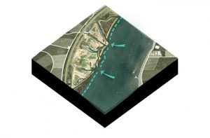
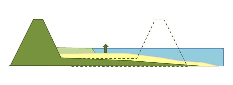
By re-inundating land the coastline is placed backwards and a new intertidal area is created. The area is enclosed by a new dike on the landside to ensure safety of the hinterland. The goal is to create the right circumstances for succession of salt marsh vegetation. Once salt marshes develop, the vegetation will enhance sedimentation, the area will increase in elevation and will thus be able to grow with sea level rise. Furthermore, salt marshes can reduce wave energy and improve the stability of the dike.
Managed realignment can be applied to many different situations that fall within the scope of coastal and flood management. Success is also dependent on local boundary conditions. It is important to be clear on the aim and purpose of the proposed project at the beginning. Without this it may be difficult later to determine the success/failure of the scheme in meeting its objectives. It is also important at the outset of a project to identify any potential opportunities and/or constraints. Managed Realignment presents the opportunity for a variety of benefits, though such opportunities may also have associated constraints.
This Concept describes the practice of managed realignment as an approach that combines coastal defense with creation of new intertidal and salt marsh habitat. Managed realignment is mostly used in low lying estuarine and coastal areas to counter-act coastal erosion and coastal squeeze as a consequence of sea level rise or other causes and improve coastal stability. Furthermore it is a method that is used to compensate for loss of intertidal areas (tidal flats and salt marshes) and as water retention area during extreme water levels in narrow river mouths.
Areas that are of interest for the application of a coastal buffer zone are mostly low-lying areas where a secondary dike is already present for instance as remnant of former land reclamation. Some of these areas are dominated by salt water seepage which makes the land less valuable for other functions such as agriculture or housing. These areas are suitable for the application of a coastal buffer zone.
Managed realignment means a radical change for landowners, residents and people living in the surroundings of the area. Realignment, therefore, often leads to high controversy. For more information on management of the realignment process and social acceptance see Building with Nature Knowledge Base of Managed Realignment.
Related pages
A more elaborate description of managed realignment practices is given in Building with Nature Knowledge Base of Managed Realignment. Two related Concepts are Coastal buffer zones and Inland shores. Habitat requirements of salt marshes are further described in the Concept Enhancing Salt marshes.
Required skills
With this Building Solution description, anyone with a basic level of knowledge and/or working experience on coastal systems can make a first order assessment. To fully assess the potential for salt marsh development in the newly created area, one should consult the Concept Habitat requirements for salt marshes.
BwN interest
The added value of this Concept within BwN-type projects is that it enables the creation of coastal protection systems utilizing the ecosystem services of salt marshes. The Building Solution is mainly applicable in the planning and design phase.
Advantages
- Attenuation of wave energy by intertidal habitats. Waves reaching the shore are less powerful and sea defence can therefore be of reduced height and strength or even be absent
- Possible reduction of coastal defence costs mainly due to decreased maintenance and a lower allowable safety standard
- Provide long term reduced risk of flooding and coastal erosion, because salt marshes are able to grow with the sea level, given sufficient sediment is available
- Prevention of “coastal squeeze”, the reduction of foreshore as result of sea level rise, by removal of the sea defence; salt marshes are able to migrate shore wards with the rising sea level
- Provide a wide range of ecosystem services besides coastal protection like mitigation of CO2 emissions, nutrient cycling, improvement of air and water quality, support of fish population for fisheries and contribution to an attractive landscape for visitors (Barbier et al., 2011)
- Creation of new intertidal habitats which are valuable from a conservation point of view for birds, fish, macrobenthos and the support of the estuarine food web
- Potential for recreation and aquaculture or cultivation of saline crops
Disadvantages
- Former land use has to give way. This is a radical change for landowners, residents and people in the surroundings that recreate in the area. Often realignment causes high (social and political) controversy because of the resettlement that is involved and (agricultural) land is intentionally flooded by the sea. The choice of this measure therefore deserves careful consideration
- Relocation of houses, buildings and infrastructure is very costly
- Loss of agricultural land
- Managed realignment is a relatively young concept. There is little experience and knowledge on best practices and feasibility